
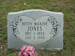


Betty Maxine Jenkins Jones
| Birth | : | 1 Dec 1932 Bena, Gloucester County, Virginia, USA |
| Death | : | 8 Jan 1998 Birch Tree, Shannon County, Missouri, USA |
| Burial | : | St. Stephen's Churchyard, North Meols, West Lancashire District, England |
| Coordinate | : | 53.6813720, -2.9248140 |
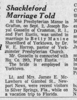
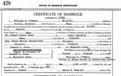
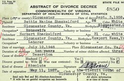
| Description | : | Full Name: Betty Maxine Jones Shackleford Gosselin Jones Betty Jenkins in the 1940 United States Federal Census Name: Betty Jenkins Age: 7 Estimated Birth Year: abt 1933 Gender: Female Race: White Birthplace: Virginia Marital Status: Single Relation to Head of House: Daughter Home in 1940: Abingdon, Gloucester, Virginia Map of Home in 1940: Abingdon, Gloucester, Virginia Inferred Residence in 1935: Abingdon, Gloucester, Virginia Residence in 1935: Abingdon Sheet Number: 18B Attended School or College: Yes Highest Grade Completed: Elementary school, 1st grade Neighbors: View others on page Household Members Age Relationship Hermase W Jenkins 39 Head Bessie W Jenkins... Read More |
frequently asked questions (FAQ):
-
Where is Betty Maxine Jenkins Jones's memorial?
Betty Maxine Jenkins Jones's memorial is located at: St. Stephen's Churchyard, North Meols, West Lancashire District, England.
-
When did Betty Maxine Jenkins Jones death?
Betty Maxine Jenkins Jones death on 8 Jan 1998 in Birch Tree, Shannon County, Missouri, USA
-
Where are the coordinates of the Betty Maxine Jenkins Jones's memorial?
Latitude: 53.6813720
Longitude: -2.9248140
Family Members:
Parent
Spouse

Flowers:


Nearby Cemetories:
1. St. Stephen's Churchyard
North Meols, West Lancashire District, England
Coordinate: 53.6813720, -2.9248140
2. Saint John Crossens Churchyard
Crossens, Metropolitan Borough of Sefton, England
Coordinate: 53.6733410, -2.9478740
3. St Cuthberts Churchyard
Southport, Metropolitan Borough of Sefton, England
Coordinate: 53.6603230, -2.9620310
4. Emmanuel Parish Church
Southport, Metropolitan Borough of Sefton, England
Coordinate: 53.6604534, -2.9748117
5. Emmanuel Church Garden of Remembrance
North Meols, West Lancashire District, England
Coordinate: 53.6607130, -2.9753420
6. Holy Trinity Church
Southport, Metropolitan Borough of Sefton, England
Coordinate: 53.6503800, -2.9969150
7. St. Marie on the Sands
Southport, Metropolitan Borough of Sefton, England
Coordinate: 53.6524320, -3.0023440
8. All Saints Churchyard
Hesketh with Becconsall, West Lancashire District, England
Coordinate: 53.7028189, -2.8400142
9. St John the Divine
Lytham Saint Annes, Fylde Borough, England
Coordinate: 53.7367060, -2.9548070
10. Becconsall Old Church Churchyard
Hesketh with Becconsall, West Lancashire District, England
Coordinate: 53.7023610, -2.8314810
11. St. Mary's Churchyard
Tarleton, West Lancashire District, England
Coordinate: 53.6746100, -2.8239200
12. Southport Crematorium
Scarisbrick, West Lancashire District, England
Coordinate: 53.6235810, -2.9600210
13. St. Cuthbert Churchyard
Lytham Saint Annes, Fylde Borough, England
Coordinate: 53.7376560, -2.9761270
14. Ardwick Cemetery
Ardwick, Metropolitan Borough of Manchester, England
Coordinate: 53.6302778, -2.9900000
15. Christ Church Churchyard
Southport, Metropolitan Borough of Sefton, England
Coordinate: 53.6327778, -2.9953770
16. Duke Street Cemetery
Southport, Metropolitan Borough of Sefton, England
Coordinate: 53.6343536, -2.9993131
17. Saltcoates Roman Catholic Cemetery
Lytham Saint Annes, Fylde Borough, England
Coordinate: 53.7463000, -2.9448940
18. St. Michael and All Angel Churchyard
Much Hoole, South Ribble Borough, England
Coordinate: 53.6942950, -2.8143830
19. St. Mark Churchyard
Scarisbrick, West Lancashire District, England
Coordinate: 53.6134600, -2.9403800
20. St. Elizabeth's Churchyard
Scarisbrick, West Lancashire District, England
Coordinate: 53.6124460, -2.9206340
21. Parish Church of St. Paul
Warton, Fylde Borough, England
Coordinate: 53.7502621, -2.8932641
22. Congregational Church
Bretherton, Chorley Borough, England
Coordinate: 53.6780260, -2.7986920
23. St. John the Baptist Churchyard
Bretherton, Chorley Borough, England
Coordinate: 53.6776300, -2.7952200
24. Woodland Burial Ground
Much Hoole, South Ribble Borough, England
Coordinate: 53.6986390, -2.7974440