
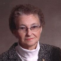
Beverly Jean Mohr Dodge
| Birth | : | 19 Jul 1931 Estherville, Emmet County, Iowa, USA |
| Death | : | 28 Sep 2018 Milford, Dickinson County, Iowa, USA |
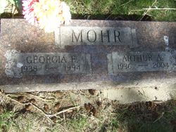
| Burial | : | Fairview Cemetery, Terril, Dickinson County, USA |
| Coordinate | : | 43.2977982, -94.9349976 |
| Description | : | Beverly Dodge (193619578) Suggested edit: Funeral services for Bev Dodge, 87, of Terril, will be held at 2 pm, Wednesday, October 3, 2018, at United Methodist Church in Terril. Interment will be at Fairview Cemetery in Terril. Visitation will be Tuesday, October 2, 2018 from 5-7 at Turner Jenness Funeral Home in Milford. Beverly Jean Dodge, the daughter of Albert and Esther (Sullivan) Mohr, was born in Estherville, Iowa on July 19, 1931. Five sisters and one brother joined Beverly in her family. The Mohr family lived in Wallingford, Iowa, where Beverly attended country school. When Beverly was in... Read More |
frequently asked questions (FAQ):
-
Where is Beverly Jean Mohr Dodge's memorial?
Beverly Jean Mohr Dodge's memorial is located at: Fairview Cemetery, Terril, Dickinson County, USA.
-
When did Beverly Jean Mohr Dodge death?
Beverly Jean Mohr Dodge death on 28 Sep 2018 in Milford, Dickinson County, Iowa, USA
-
Where are the coordinates of the Beverly Jean Mohr Dodge's memorial?
Latitude: 43.2977982
Longitude: -94.9349976
Family Members:
Parent

Spouse
Siblings
Flowers:


Nearby Cemetories:
1. Fairview Cemetery
Terril, Dickinson County, USA
Coordinate: 43.2977982, -94.9349976
2. Richland Township Cemetery
Terril, Dickinson County, USA
Coordinate: 43.3565323, -94.9927821
3. Saint Patricks Cemetery
Estherville, Emmet County, USA
Coordinate: 43.3843994, -94.8283005
4. Oak Hill Cemetery
Estherville, Emmet County, USA
Coordinate: 43.3986015, -94.8518982
5. Wallingford Lutheran Cemetery
Wallingford, Emmet County, USA
Coordinate: 43.3128014, -94.7731018
6. Lost Island Lutheran Cemetery
Lost Island Township, Palo Alto County, USA
Coordinate: 43.1980000, -94.8375000
7. Graettinger City Cemetery
Graettinger, Palo Alto County, USA
Coordinate: 43.2550011, -94.7722015
8. Saint Jacobs Cemetery
Graettinger, Palo Alto County, USA
Coordinate: 43.2546997, -94.7705994
9. East Side Cemetery
Estherville, Emmet County, USA
Coordinate: 43.4068985, -94.8264008
10. Superior Township Cemetery
Superior, Dickinson County, USA
Coordinate: 43.4399986, -94.9533005
11. Fairview Cemetery
Clay County, USA
Coordinate: 43.1899986, -95.0800018
12. East Side Memorial Cemetery
Estherville, Emmet County, USA
Coordinate: 43.4267750, -94.8265600
13. Norwegian Cemetery
Estherville, Emmet County, USA
Coordinate: 43.4291992, -94.8261032
14. Estherville Lutheran Cemetery
Estherville, Emmet County, USA
Coordinate: 43.4298000, -94.8263000
15. Saint Paul Lutheran Cemetery
Walnut Township, Palo Alto County, USA
Coordinate: 43.1866740, -94.7872050
16. Bedell Gravesite
Spirit Lake, Dickinson County, USA
Coordinate: 43.4128430, -95.0773690
17. Milford Cemetery
Milford, Dickinson County, USA
Coordinate: 43.3092003, -95.1481018
18. Okoboji Cemetery
Arnolds Park, Dickinson County, USA
Coordinate: 43.3649406, -95.1303558
19. Highland Cemetery
Highland Township, Palo Alto County, USA
Coordinate: 43.1497002, -94.8578033
20. Lakeview Gardens Cemetery
Spirit Lake, Dickinson County, USA
Coordinate: 43.3925000, -95.1119000
21. Rose Hill Cemetery (Defunct)
Spirit Lake, Dickinson County, USA
Coordinate: 43.4077600, -95.0976130
22. Pioneer Cemetery
Arnolds Park, Dickinson County, USA
Coordinate: 43.3655000, -95.1403000
23. Gardner Family Cemetery
Arnolds Park, Dickinson County, USA
Coordinate: 43.3654410, -95.1403480
24. Valley View Cemetery
Walnut Township, Palo Alto County, USA
Coordinate: 43.2428000, -94.7212000