
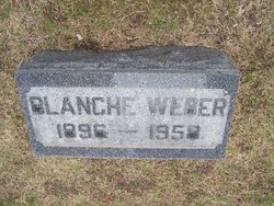

Blanche Lois Day Weber
| Birth | : | 26 May 1896 Iowa, USA |
| Death | : | 14 Jan 1958 Sedro-Woolley, Skagit County, Washington, USA |
| Burial | : | Marble Valley Cemetery, Gilmore City, Humboldt County, USA |
| Coordinate | : | 42.7458850, -94.4430150 |
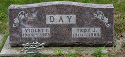
| Description | : | Blanch Day Weber 1896 - 1958 |
frequently asked questions (FAQ):
-
Where is Blanche Lois Day Weber's memorial?
Blanche Lois Day Weber's memorial is located at: Marble Valley Cemetery, Gilmore City, Humboldt County, USA.
-
When did Blanche Lois Day Weber death?
Blanche Lois Day Weber death on 14 Jan 1958 in Sedro-Woolley, Skagit County, Washington, USA
-
Where are the coordinates of the Blanche Lois Day Weber's memorial?
Latitude: 42.7458850
Longitude: -94.4430150
Family Members:
Parent

Spouse

Siblings

Children
Flowers:


Nearby Cemetories:
1. Marble Valley Cemetery
Gilmore City, Humboldt County, USA
Coordinate: 42.7458850, -94.4430150
2. Saint Johns Catholic Cemetery
Gilmore City, Pocahontas County, USA
Coordinate: 42.7332993, -94.4672012
3. Mount Hope Cemetery
Unique, Humboldt County, USA
Coordinate: 42.7169250, -94.3740570
4. Clinton-Garfield Cemetery
Rolfe, Pocahontas County, USA
Coordinate: 42.8055300, -94.5202500
5. Saint Margarets Cemetery
Rolfe, Pocahontas County, USA
Coordinate: 42.8164978, -94.5307465
6. Old Rolfe Cemetery
Rolfe, Pocahontas County, USA
Coordinate: 42.8403511, -94.4764175
7. McKnight Cemetery
Bode, Humboldt County, USA
Coordinate: 42.8635100, -94.4055600
8. Omer-Thorsen Farm Cemetery
Ottosen, Humboldt County, USA
Coordinate: 42.8735742, -94.4085743
9. Rutland Township Cemetery
Rutland, Humboldt County, USA
Coordinate: 42.7574997, -94.2652969
10. Saint Johns Lutheran Cemetery
Palmer, Pocahontas County, USA
Coordinate: 42.6268997, -94.5205994
11. Our Saviors Cemetery
Humboldt County, USA
Coordinate: 42.6596985, -94.2956009
12. Powhatan Cemetery
Plover, Pocahontas County, USA
Coordinate: 42.8557396, -94.5801773
13. Union Cemetery
Ottosen, Humboldt County, USA
Coordinate: 42.8879128, -94.3792496
14. Union Cemetery
Humboldt, Humboldt County, USA
Coordinate: 42.7407990, -94.2375031
15. Saint Patricks Cemetery
Clare, Webster County, USA
Coordinate: 42.5943985, -94.4419022
16. Calvary Cemetery
Pocahontas, Pocahontas County, USA
Coordinate: 42.7335000, -94.6597000
17. Summit Hill Cemetery
Pocahontas, Pocahontas County, USA
Coordinate: 42.7315000, -94.6595000
18. Lizard Cemetery
Palmer, Pocahontas County, USA
Coordinate: 42.5875015, -94.4796982
19. Saint Olaf Churchyard Cemetery
Bode, Humboldt County, USA
Coordinate: 42.8653600, -94.2858300
20. Saint Paul Lutheran Cemetery
Palmer, Pocahontas County, USA
Coordinate: 42.6176000, -94.5893500
21. Palmer Cemetery
Palmer, Pocahontas County, USA
Coordinate: 42.6166992, -94.5894012
22. Saint Olaf Lutheran Cemetery
Bode, Humboldt County, USA
Coordinate: 42.8628000, -94.2773000
23. Saint Josephs Cemetery
Palmer, Pocahontas County, USA
Coordinate: 42.6342010, -94.6188965
24. Jackson Center Cemetery
Clare, Webster County, USA
Coordinate: 42.5783005, -94.3741989