

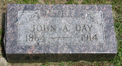
John A. Day
| Birth | : | 1864 |
| Death | : | 1914 |
| Burial | : | Marble Valley Cemetery, Gilmore City, Humboldt County, USA |
| Coordinate | : | 42.7458850, -94.4430150 |
| Description | : | From The Reveille, January 22, 1914, page 2: Word was received here Monday afternoon of the death of John Day Jr., who went to Chicago recently to receive medical treatment. Mr. Day was a well-to-do farmer and was well known throughout the country, as a stock buyer. He leaves a wife, ten children and an aged father to mourn his loss. ~~~~~~~~~~~~~~~~~~~~~~~~~~~~~ From the Humboldt (Iowa) Republican Jan. 30, 1914, page 5: John Day John Day is dead, was the startling word received from Chicago last week. He went to Chicago hospital for an operation which was performed, and was reported to have been... Read More |
frequently asked questions (FAQ):
-
Where is John A. Day's memorial?
John A. Day's memorial is located at: Marble Valley Cemetery, Gilmore City, Humboldt County, USA.
-
When did John A. Day death?
John A. Day death on 1914 in
-
Where are the coordinates of the John A. Day's memorial?
Latitude: 42.7458850
Longitude: -94.4430150
Family Members:
Parent

Spouse
Siblings

Children

Flowers:


Nearby Cemetories:
1. Marble Valley Cemetery
Gilmore City, Humboldt County, USA
Coordinate: 42.7458850, -94.4430150
2. Saint Johns Catholic Cemetery
Gilmore City, Pocahontas County, USA
Coordinate: 42.7332993, -94.4672012
3. Mount Hope Cemetery
Unique, Humboldt County, USA
Coordinate: 42.7169250, -94.3740570
4. Clinton-Garfield Cemetery
Rolfe, Pocahontas County, USA
Coordinate: 42.8055300, -94.5202500
5. Saint Margarets Cemetery
Rolfe, Pocahontas County, USA
Coordinate: 42.8164978, -94.5307465
6. Old Rolfe Cemetery
Rolfe, Pocahontas County, USA
Coordinate: 42.8403511, -94.4764175
7. McKnight Cemetery
Bode, Humboldt County, USA
Coordinate: 42.8635100, -94.4055600
8. Omer-Thorsen Farm Cemetery
Ottosen, Humboldt County, USA
Coordinate: 42.8735742, -94.4085743
9. Rutland Township Cemetery
Rutland, Humboldt County, USA
Coordinate: 42.7574997, -94.2652969
10. Saint Johns Lutheran Cemetery
Palmer, Pocahontas County, USA
Coordinate: 42.6268997, -94.5205994
11. Our Saviors Cemetery
Humboldt County, USA
Coordinate: 42.6596985, -94.2956009
12. Powhatan Cemetery
Plover, Pocahontas County, USA
Coordinate: 42.8557396, -94.5801773
13. Union Cemetery
Ottosen, Humboldt County, USA
Coordinate: 42.8879128, -94.3792496
14. Union Cemetery
Humboldt, Humboldt County, USA
Coordinate: 42.7407990, -94.2375031
15. Saint Patricks Cemetery
Clare, Webster County, USA
Coordinate: 42.5943985, -94.4419022
16. Calvary Cemetery
Pocahontas, Pocahontas County, USA
Coordinate: 42.7335000, -94.6597000
17. Summit Hill Cemetery
Pocahontas, Pocahontas County, USA
Coordinate: 42.7315000, -94.6595000
18. Lizard Cemetery
Palmer, Pocahontas County, USA
Coordinate: 42.5875015, -94.4796982
19. Saint Olaf Churchyard Cemetery
Bode, Humboldt County, USA
Coordinate: 42.8653600, -94.2858300
20. Saint Paul Lutheran Cemetery
Palmer, Pocahontas County, USA
Coordinate: 42.6176000, -94.5893500
21. Palmer Cemetery
Palmer, Pocahontas County, USA
Coordinate: 42.6166992, -94.5894012
22. Saint Olaf Lutheran Cemetery
Bode, Humboldt County, USA
Coordinate: 42.8628000, -94.2773000
23. Saint Josephs Cemetery
Palmer, Pocahontas County, USA
Coordinate: 42.6342010, -94.6188965
24. Jackson Center Cemetery
Clare, Webster County, USA
Coordinate: 42.5783005, -94.3741989