
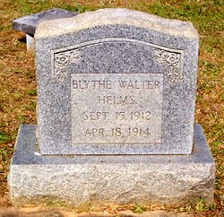
Blythe Walter Helms
| Birth | : | 15 Sep 1912 Monroe, Union County, North Carolina, USA |
| Death | : | 18 Apr 1914 Monroe, Union County, North Carolina, USA |
| Burial | : | St. Augustine's Parish Churchyard, Locking, North Somerset Unitary Authority, England |
| Coordinate | : | 51.3322900, -2.9147683 |
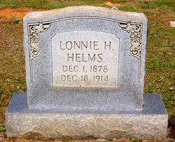
| Description | : | Son of Lonnie and Lillie Rogers Helms The little nineteen months old son of Mr. and Mrs. L. H. Helms of North Monroe died Saturday after an illness of several months. Funeral service was conducted by Rev. R. H. Kennington Sunday afternoon at 3 o'clock and the remains were buried in the Salem cemetery. The Monroe Journal, 4-21-1914, Tues., P 1 |
frequently asked questions (FAQ):
-
Where is Blythe Walter Helms's memorial?
Blythe Walter Helms's memorial is located at: St. Augustine's Parish Churchyard, Locking, North Somerset Unitary Authority, England.
-
When did Blythe Walter Helms death?
Blythe Walter Helms death on 18 Apr 1914 in Monroe, Union County, North Carolina, USA
-
Where are the coordinates of the Blythe Walter Helms's memorial?
Latitude: 51.3322900
Longitude: -2.9147683
Family Members:
Parent
Siblings
Flowers:


Nearby Cemetories:
1. St. Augustine's Parish Churchyard
Locking, North Somerset Unitary Authority, England
Coordinate: 51.3322900, -2.9147683
2. St Mary the Virgin Churchyard
Hutton, North Somerset Unitary Authority, England
Coordinate: 51.3228030, -2.9306350
3. The Blessed Virgin Mary
Axbridge, Sedgemoor District, England
Coordinate: 51.3112017, -2.8913443
4. St. Martin's Churchyard
Worle, North Somerset Unitary Authority, England
Coordinate: 51.3609960, -2.9301250
5. Banwell War Memorial
Banwell, North Somerset Unitary Authority, England
Coordinate: 51.3278233, -2.8648124
6. Saint Peter and St. Paul Churchyard
Bleadon, North Somerset Unitary Authority, England
Coordinate: 51.3074000, -2.9458300
7. St Mark Churchyard
Weston-super-Mare, North Somerset Unitary Authority, England
Coordinate: 51.3640650, -2.9195540
8. St. Andrew's Churchyard
Banwell, North Somerset Unitary Authority, England
Coordinate: 51.3280700, -2.8637000
9. St Andrew's Church
Loxton, North Somerset Unitary Authority, England
Coordinate: 51.2981560, -2.8962140
10. Ebdon Road Crematorium and Cemetery
Weston-super-Mare, North Somerset Unitary Authority, England
Coordinate: 51.3707090, -2.9254530
11. Weston-Super-Mare Cemetery
Weston-super-Mare, North Somerset Unitary Authority, England
Coordinate: 51.3541300, -2.9676900
12. St Nicholas Churchyard (New)
Uphill, North Somerset Unitary Authority, England
Coordinate: 51.3246210, -2.9778420
13. Weston-super-Mare Emmanuel Churchyard
Weston-super-Mare, North Somerset Unitary Authority, England
Coordinate: 51.3458940, -2.9773860
14. St Paul's Churchyard
Kewstoke, North Somerset Unitary Authority, England
Coordinate: 51.3655390, -2.9566120
15. Saint Pauls Churchyard
Kewstoke, North Somerset Unitary Authority, England
Coordinate: 51.3655500, -2.9568900
16. Old St Nicholas Churchyard
Uphill, North Somerset Unitary Authority, England
Coordinate: 51.3203480, -2.9828110
17. St. John the Baptist Churchyard
Weston-super-Mare, North Somerset Unitary Authority, England
Coordinate: 51.3523010, -2.9813260
18. Saint Andrew Churchyard
Compton Bishop, Sedgemoor District, England
Coordinate: 51.2943290, -2.8678900
19. Winscombe and Sandford Cemetery
Winscombe, North Somerset Unitary Authority, England
Coordinate: 51.3223861, -2.8386889
20. Holy Saviour Churchyard
Puxton, North Somerset Unitary Authority, England
Coordinate: 51.3652680, -2.8536510
21. St. James the Great Churchyard
Winscombe, North Somerset Unitary Authority, England
Coordinate: 51.3059750, -2.8456900
22. St Anne's Church Hewish
Weston-super-Mare, North Somerset Unitary Authority, England
Coordinate: 51.3740520, -2.8666300
23. Wick St. Lawrence Churchyard
Wick St Lawrence, North Somerset Unitary Authority, England
Coordinate: 51.3844000, -2.9117000
24. St Christopher's Churchyard
Lympsham, Sedgemoor District, England
Coordinate: 51.2826740, -2.9546028