
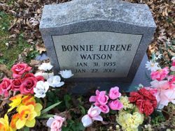
Bonnie Lurene Pumphrey Watson
| Birth | : | 31 Jul 1935 Lewis County, West Virginia, USA |
| Death | : | 22 Jan 2012 Morgantown, Monongalia County, West Virginia, USA |
| Burial | : | Pumphrey Cemetery, Orlando, Lewis County, USA |
| Coordinate | : | 38.9275880, -80.6216500 |
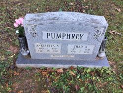
| Description | : | Obituary: Bonnie Lurene Watson, 76, of Glady Fork Road Weston passed away on Sunday, January 22, 2012 in Ruby Memorial Hospital of Morgantown following a brief illness. She was born in Lewis County on January 31, 1935: daughter of the late Thad Pumphrey and Angelettie (Sprouse) Pumphrey. Mrs. Watson married Robert Lee Watson, who preceded her in death on November 31, 2007. Mrs. Watson is survived by two daughters: Debra Helmick of Walkersville and Vicki (Almond) Riffle of Jane Lew and two sons: Roger Watson and James (Vickie) Watson both of Weston. She is also survived by five grandchildren:... Read More |
frequently asked questions (FAQ):
-
Where is Bonnie Lurene Pumphrey Watson's memorial?
Bonnie Lurene Pumphrey Watson's memorial is located at: Pumphrey Cemetery, Orlando, Lewis County, USA.
-
When did Bonnie Lurene Pumphrey Watson death?
Bonnie Lurene Pumphrey Watson death on 22 Jan 2012 in Morgantown, Monongalia County, West Virginia, USA
-
Where are the coordinates of the Bonnie Lurene Pumphrey Watson's memorial?
Latitude: 38.9275880
Longitude: -80.6216500
Family Members:
Parent
Spouse

Siblings
Children
Flowers:


Nearby Cemetories:
1. Pumphrey Cemetery
Orlando, Lewis County, USA
Coordinate: 38.9275880, -80.6216500
2. Mick Cemetery
Gilmer County, USA
Coordinate: 38.9157200, -80.6316400
3. Finster Chapel Cemetery
Peterson, Lewis County, USA
Coordinate: 38.9300003, -80.5999985
4. Queen Family Cemetery
Copley, Lewis County, USA
Coordinate: 38.9499000, -80.6130000
5. Heater Cemetery
Burnsville, Braxton County, USA
Coordinate: 38.9024560, -80.6100370
6. Tumbling Cemetery
Gilmer County, USA
Coordinate: 38.9085999, -80.6594009
7. Tomblin Cemetery
Blackburn, Gilmer County, USA
Coordinate: 38.9076650, -80.6597330
8. Montgomery Cemetery
Bealls Mills, Lewis County, USA
Coordinate: 38.9648890, -80.6035400
9. Blackburn Cemetery
Blackburn, Gilmer County, USA
Coordinate: 38.9235700, -80.6743200
10. Boilon Cemetery
Gilmer County, USA
Coordinate: 38.9519005, -80.6718979
11. Saint Bridget's Church Cemetery
Weston, Lewis County, USA
Coordinate: 38.9319400, -80.5572970
12. Schoonover-Dawson Cemetery
Donlan, Gilmer County, USA
Coordinate: 38.9461770, -80.6854790
13. Barrett Cemetery
Burnsville, Braxton County, USA
Coordinate: 38.8778000, -80.6528015
14. Canfield Cemetery
Gilmer, Gilmer County, USA
Coordinate: 38.9071999, -80.6900024
15. Rogers Cemetery
Gilmer County, USA
Coordinate: 38.9406013, -80.6936035
16. Locust Knob Cemetery
Stouts Mills, Gilmer County, USA
Coordinate: 38.8990000, -80.6880000
17. Snyder Cemetery
Gilmer County, USA
Coordinate: 38.9006004, -80.6964035
18. Keith Cemetery
Gilmer County, USA
Coordinate: 38.9561005, -80.6986008
19. Old Field Fork Cemetery
Lewis County, USA
Coordinate: 38.9827995, -80.6710968
20. Saint Bernard Church Cemetery
Weston, Lewis County, USA
Coordinate: 38.9928000, -80.5926940
21. Dyer Cemetery
Gilmer County, USA
Coordinate: 38.9319000, -80.7110977
22. McHenry Cemetery
Gilmer County, USA
Coordinate: 38.9341870, -80.7130200
23. Peterson Village Cemetery
Peterson, Lewis County, USA
Coordinate: 38.8938270, -80.5400510
24. Hoover Cemetery
Burnsville, Braxton County, USA
Coordinate: 38.8619600, -80.6644170