
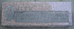
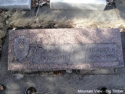
Burton Steward Smith
| Birth | : | 6 Jan 1900 Hamlin County, South Dakota, USA |
| Death | : | 17 Jan 1971 Columbus, Stillwater County, Montana, USA |
| Burial | : | Saint John Street Cemetery, Monticello, Sullivan County, USA |
| Coordinate | : | 41.6524400, -74.6860400 |
| Plot | : | Section 5 Block 22 Lot 3 Grave 3 |
| Inscription | : | BURTON S. 1900 - 1971 Married March 26, 1921 |
| Description | : | Big Timber Pioneer, 24 June 1971 Funeral services were held on Monday, June 21 from the Lowry Funeral Home for Burton S. Smith, 71, well known retired rancher of this area, who died Thursday night at the Stilwater Community Hospital from a heart condition, Rev. W. F. Clingman of the Evangelical Church of North America of Reed Point officiated. Mrs. William Cremer, Jr., sang "How Great Thou Art," and "Beyond the Sunset." accompanied by Miss Deborah Lowry, organist. Casketbearers were Alfred Anderson, Jr., Clarence Flattum, Helmar Branae, Henry Hausserman, Art Meserve of Cat Creek, Montana, and Herb Uhrich of Columbus.... Read More |
frequently asked questions (FAQ):
-
Where is Burton Steward Smith's memorial?
Burton Steward Smith's memorial is located at: Saint John Street Cemetery, Monticello, Sullivan County, USA.
-
When did Burton Steward Smith death?
Burton Steward Smith death on 17 Jan 1971 in Columbus, Stillwater County, Montana, USA
-
Where are the coordinates of the Burton Steward Smith's memorial?
Latitude: 41.6524400
Longitude: -74.6860400
Family Members:
Parent

Spouse

Siblings


Nearby Cemetories:
1. Saint John Street Cemetery
Monticello, Sullivan County, USA
Coordinate: 41.6524400, -74.6860400
2. Rock Ridge Cemetery
Monticello, Sullivan County, USA
Coordinate: 41.6514015, -74.6686020
3. Saint Peter's Cemetery
Monticello, Sullivan County, USA
Coordinate: 41.6543999, -74.6669006
4. Workman Circle #601 Cemetery
Monticello, Sullivan County, USA
Coordinate: 41.6574430, -74.6675850
5. Cold Spring Road Cemetery
Sullivan County, USA
Coordinate: 41.6572420, -74.6663110
6. Monticello Brotherhood Aid Society Cemetery
Monticello, Sullivan County, USA
Coordinate: 41.6577350, -74.6663000
7. Temple Sholom Cemetery
Monticello, Sullivan County, USA
Coordinate: 41.6383200, -74.6388900
8. North Settlement Cemetery
Monticello, Sullivan County, USA
Coordinate: 41.6929520, -74.7060870
9. Mapes Cemetery
Monticello, Sullivan County, USA
Coordinate: 41.6119400, -74.7103100
10. Messenger Cemetery
Monticello, Sullivan County, USA
Coordinate: 41.6247500, -74.6395600
11. Jewish General Aid Cemetery
Sullivan County, USA
Coordinate: 41.6944200, -74.7161700
12. Bridgeville Cemetery
Bridgeville, Sullivan County, USA
Coordinate: 41.6305800, -74.6149600
13. Hornbeck Cemetery
Hurleyville, Sullivan County, USA
Coordinate: 41.7171340, -74.6782850
14. South Fallsburg Hebrew Cemetery
Glen Wild, Sullivan County, USA
Coordinate: 41.6606278, -74.5979095
15. Glen Wild Cemetery
Glen Wild, Sullivan County, USA
Coordinate: 41.6599800, -74.5977600
16. Hebrew Congregation Cemetery
Glen Wild, Sullivan County, USA
Coordinate: 41.6600090, -74.5963860
17. Congregation Ohave Shalom Synagogue Cemetery
Glen Wild, Sullivan County, USA
Coordinate: 41.6597420, -74.5959360
18. Glen Wild Synagogue Cemetery
Glen Wild, Sullivan County, USA
Coordinate: 41.6597870, -74.5957680
19. Congregation B'nai Israel Cemetery
Glen Wild, Sullivan County, USA
Coordinate: 41.6606800, -74.5955900
20. Workmans Circle #281 Cemetery
Glen Wild, Sullivan County, USA
Coordinate: 41.6599167, -74.5950250
21. Grays Cemetery
Fallsburg, Sullivan County, USA
Coordinate: 41.6793900, -74.6014200
22. Simenitzky Family Cemetery
Mongaup Valley, Sullivan County, USA
Coordinate: 41.6628280, -74.7782960
23. Brookside Cemetery
Harris, Sullivan County, USA
Coordinate: 41.7155600, -74.7264800
24. Swan-Kiersted Cemetery
Mongaup Valley, Sullivan County, USA
Coordinate: 41.6630120, -74.7786300