
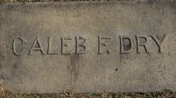
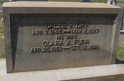
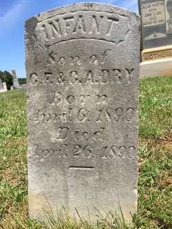
Caleb Franklin Dry
| Birth | : | 3 Apr 1845 Cabarrus County, North Carolina, USA |
| Death | : | 8 Mar 1927 Big Lick, Stanly County, North Carolina, USA |
| Burial | : | St Hugh's Church, Durleigh, Sedgemoor District, England |
| Coordinate | : | 51.1198090, -3.0375260 |
| Description | : | Parents: Sandy M. Drye & Elizabeth Stallings Brother: Daniel Monroe Drye |
frequently asked questions (FAQ):
-
Where is Caleb Franklin Dry's memorial?
Caleb Franklin Dry's memorial is located at: St Hugh's Church, Durleigh, Sedgemoor District, England.
-
When did Caleb Franklin Dry death?
Caleb Franklin Dry death on 8 Mar 1927 in Big Lick, Stanly County, North Carolina, USA
-
Where are the coordinates of the Caleb Franklin Dry's memorial?
Latitude: 51.1198090
Longitude: -3.0375260
Family Members:
Parent
Spouse
Siblings
Children

Flowers:


Nearby Cemetories:
1. St Hugh's Church
Durleigh, Sedgemoor District, England
Coordinate: 51.1198090, -3.0375260
2. Quantock Road Cemetery
Bridgwater, Sedgemoor District, England
Coordinate: 51.1284270, -3.0285630
3. Wembdon Road Cemetery
Bridgwater, Sedgemoor District, England
Coordinate: 51.1280877, -3.0138897
4. Quaker Burial Ground
Bridgwater, Sedgemoor District, England
Coordinate: 51.1261740, -3.0078020
5. Gray Friar's
Bridgwater, Sedgemoor District, England
Coordinate: 51.1264260, -3.0065160
6. St George Churchyard
Wembdon, Sedgemoor District, England
Coordinate: 51.1364420, -3.0171170
7. St. Mary's Churchyard
Bridgwater, Sedgemoor District, England
Coordinate: 51.1277430, -3.0050330
8. Bridgwater Baptist Church
Bridgwater, Sedgemoor District, England
Coordinate: 51.1272613, -3.0046282
9. St Edward King and Martyr Churchyard
Goathurst, Sedgemoor District, England
Coordinate: 51.1034930, -3.0633930
10. Former Holy Trinity Churchyard
Bridgwater, Sedgemoor District, England
Coordinate: 51.1261850, -3.0021850
11. St John The Baptist Churchyard
Bridgwater, Sedgemoor District, England
Coordinate: 51.1311160, -2.9969910
12. Heathfield Cemetery
North Petherton, Sedgemoor District, England
Coordinate: 51.0957200, -3.0081100
13. St. Mary Parish Churchyard
North Petherton, Sedgemoor District, England
Coordinate: 51.0920790, -3.0149060
14. St. Michael's Churchyard
Enmore, Sedgemoor District, England
Coordinate: 51.1110830, -3.0872790
15. Holy Trinity Churchyard
Chilton Trinity, Sedgemoor District, England
Coordinate: 51.1474390, -3.0072360
16. Blessed Virgin Mary Churchyard
Cannington, Sedgemoor District, England
Coordinate: 51.1500970, -3.0622850
17. Charlynch Church of Saint Mary
Spaxton, Sedgemoor District, England
Coordinate: 51.1342600, -3.0879100
18. St. John Bristol Road Cemetery
Bridgwater, Sedgemoor District, England
Coordinate: 51.1391470, -2.9901660
19. Cannington Cemetery
Cannington, Sedgemoor District, England
Coordinate: 51.1500620, -3.0697070
20. Spaxton Extension Cemetery
Spaxton, Sedgemoor District, England
Coordinate: 51.1267650, -3.1082920
21. Saint Margaret's Churchyard
Spaxton, Sedgemoor District, England
Coordinate: 51.1273090, -3.1087000
22. St. Peter's Churchyard
North Newton, Sedgemoor District, England
Coordinate: 51.0751380, -2.9990730
23. Saint Giles Church
Thurloxton, Sedgemoor District, England
Coordinate: 51.0684800, -3.0365270
24. St Mary and All Saints Churchyard
Broomfield, Sedgemoor District, England
Coordinate: 51.0821940, -3.1090780