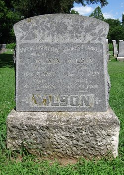
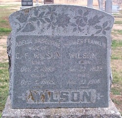
Capt Charles Franklin Wilson
| Birth | : | 23 Jan 1832 Monroe County, Tennessee, USA |
| Death | : | 23 Aug 1906 Elk County, Kansas, USA |
| Burial | : | Garden Of Memories Cemetery, Sikeston, Scott County, USA |
| Coordinate | : | 36.8650017, -89.6035995 |
| Description | : | Capt. Charles Franklin Wilson He was born in Monroe County, southeastern Tennessee, January 23, 1832, where he grew to manhood. In 1861, Frank, controlled by the sentiment most popular in that section, volunteered in the Confederate Infantry. He was soon given command of a company which he led in the vicissitudes of four years of active service. He was through twenty seven battles; not counting skirmishes. At the battle of Fisher's Hill he was severly wounded in the thigh. After this he was furnished a horse which he rode at the close of the rebellion. Frank... Read More |
frequently asked questions (FAQ):
-
Where is Capt Charles Franklin Wilson's memorial?
Capt Charles Franklin Wilson's memorial is located at: Garden Of Memories Cemetery, Sikeston, Scott County, USA.
-
When did Capt Charles Franklin Wilson death?
Capt Charles Franklin Wilson death on 23 Aug 1906 in Elk County, Kansas, USA
-
Where are the coordinates of the Capt Charles Franklin Wilson's memorial?
Latitude: 36.8650017
Longitude: -89.6035995
Family Members:
Parent
Spouse
Siblings
Children
Flowers:
Nearby Cemetories:
1. Garden Of Memories Cemetery
Sikeston, Scott County, USA
Coordinate: 36.8650017, -89.6035995
2. Sunset of Memories Cemetery
Sikeston, Scott County, USA
Coordinate: 36.8731800, -89.6074100
3. Sikeston Memorial Park
Sikeston, New Madrid County, USA
Coordinate: 36.8630981, -89.5867004
4. Sikeston City Cemetery
Sikeston, Scott County, USA
Coordinate: 36.8696442, -89.5867538
5. Hunter Memorial Cemetery
Sikeston, Scott County, USA
Coordinate: 36.8844200, -89.5952800
6. Sikes Family Cemetery
Sikeston, New Madrid County, USA
Coordinate: 36.8410380, -89.5697350
7. Hart Cemetery
Miner, Scott County, USA
Coordinate: 36.8986015, -89.5721970
8. Cobb Cemetery
Miner, Scott County, USA
Coordinate: 36.9143982, -89.5785980
9. Bright Prospect Cemetery
Miner, Scott County, USA
Coordinate: 36.8844948, -89.5352707
10. Big Opening Cemetery
New Madrid County, USA
Coordinate: 36.8089500, -89.5247100
11. Bennifield Cemetery
McMullin, Scott County, USA
Coordinate: 36.9618988, -89.6183014
12. Silent Hill Cemetery
Blodgett, Scott County, USA
Coordinate: 36.9607500, -89.5525200
13. Pleasant Valley Cemetery
Sikeston, Scott County, USA
Coordinate: 36.9418983, -89.5132980
14. Carpenter Cemetery
McMullin, Scott County, USA
Coordinate: 36.9692001, -89.6292038
15. Armer Cemetery
East Prairie, Mississippi County, USA
Coordinate: 36.8703003, -89.4608002
16. Matthews Cemetery
Matthews, New Madrid County, USA
Coordinate: 36.7496986, -89.5817032
17. Dogwood Cemetery
Dogwood, Mississippi County, USA
Coordinate: 36.8231316, -89.4546738
18. Hunter Cemetery
Haywood City, Scott County, USA
Coordinate: 36.9914017, -89.6102982
19. Bloomfield Cemetery
New Madrid County, USA
Coordinate: 36.7453003, -89.5382996
20. Big Ridge Cemetery
New Madrid County, USA
Coordinate: 36.7375200, -89.6636600
21. Noxall Cemetery
New Madrid County, USA
Coordinate: 36.7299995, -89.5802994
22. Blodgett Cemetery
Blodgett, Scott County, USA
Coordinate: 37.0015900, -89.5216500
23. Buggs Cemetery
Scott County, USA
Coordinate: 37.0113983, -89.6694031
24. Divine Temple Memorial Gardens
Oran, Scott County, USA
Coordinate: 37.0274700, -89.6251300

