
| Birth | : | 1827 Belfast, Waldo County, Maine, USA |
| Death | : | Sep 1888 Potrero, San Diego County, California, USA |
| Burial | : | Potrero Cemetery, Potrero, San Diego County, USA |
| Coordinate | : | 32.6109700, -116.6133470 |
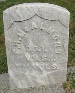
| Description | : | The estate of C.G. McAlmond was ordered settled and distributed as follows: To Alpha D. McAlmond, widow of the deceased, an undivided one-half, and the other half to the six children, one-twelfth to each. Date: Tuesday, September 25, 1888 Paper: San Diego Union (San Diego, CA) Page: 5 -------------------------------------------------------------- About 200 years ago Spanish and Indian people lived in the broad Potrero valley, which was known for its acorns, a popular food source then. The town was named in the late nineteenth century with a Spanish word that means mountain meadow or pasture. Capt. Charles McAlmond, born in Maine, and... Read More |
frequently asked questions (FAQ):
-
Where is Capt Charles Gustavis McAlmond's memorial?
Capt Charles Gustavis McAlmond's memorial is located at: Potrero Cemetery, Potrero, San Diego County, USA.
-
When did Capt Charles Gustavis McAlmond death?
Capt Charles Gustavis McAlmond death on Sep 1888 in Potrero, San Diego County, California, USA
-
Where are the coordinates of the Capt Charles Gustavis McAlmond's memorial?
Latitude: 32.6109700
Longitude: -116.6133470
Family Members:
Parent
Spouse

Siblings

Children
Flowers:


Nearby Cemetories:
1. Potrero Cemetery
Potrero, San Diego County, USA
Coordinate: 32.6109700, -116.6133470
2. Panteón Municipal No. 1
Tecate, Tecate Municipality, Mexico
Coordinate: 32.5766930, -116.6089980
3. Panteón Renacimiento
Paso del Aguila, Tecate Municipality, Mexico
Coordinate: 32.5339628, -116.6866657
4. Panteón Municipal No. 2
Tecate, Tecate Municipality, Mexico
Coordinate: 32.5244020, -116.6985279
5. Milquatay Cemetery
Campo, San Diego County, USA
Coordinate: 32.6291490, -116.4566830
6. Ortega Cemetery
Campo, San Diego County, USA
Coordinate: 32.6292800, -116.4566300
7. Parque Memorial Puerta del Edén
Valle Redondo, Tijuana Municipality, Mexico
Coordinate: 32.5135372, -116.7704848
8. Panteón Municipal No. 12
Valle Redondo, Tijuana Municipality, Mexico
Coordinate: 32.5103770, -116.7680600
9. Pantéon Municipal No. 13
Valle Redondo, Tijuana Municipality, Mexico
Coordinate: 32.5001121, -116.7620491
10. Amos Buckman Gravesite
San Diego County, USA
Coordinate: 32.7695090, -116.4901530
11. S R Gillette Burial Site
Alpine, San Diego County, USA
Coordinate: 32.8144370, -116.6219870
12. Saint Carmel Cemetery
Live Oak Springs, San Diego County, USA
Coordinate: 32.6502991, -116.3638992
13. Ellis Ranch Cemetery
Descanso, San Diego County, USA
Coordinate: 32.8316040, -116.6209620
14. Saint Francis Xavier Cemetery
Jamul, San Diego County, USA
Coordinate: 32.7033005, -116.8707962
15. Panteón Municipal No. 10
Tijuana, Tijuana Municipality, Mexico
Coordinate: 32.5101600, -116.8723400
16. Alpine Mount Pisgah Pioneer Cemetery
Alpine, San Diego County, USA
Coordinate: 32.8123930, -116.7981940
17. Sycuan Indian Reservation Cemetery
El Cajon, San Diego County, USA
Coordinate: 32.7827560, -116.8373550
18. Viejas Indian Reservation Cemetery
Alpine, San Diego County, USA
Coordinate: 32.8622400, -116.6981200
19. Alpine Cemetery
Alpine, San Diego County, USA
Coordinate: 32.8429985, -116.7664032
20. Manzanita Cemetery
Campo, San Diego County, USA
Coordinate: 32.7603510, -116.3247440
21. Panteón Municipal No. 7
Tijuana, Tijuana Municipality, Mexico
Coordinate: 32.4681331, -116.9067258
22. Monte de los Olivos
Tijuana, Tijuana Municipality, Mexico
Coordinate: 32.4602660, -116.9048890
23. Panteón Municipal No. 11
Tijuana, Tijuana Municipality, Mexico
Coordinate: 32.4555630, -116.9017570
24. Campbell-Chilwell-Mount Laguna Cemetery
Mount Laguna, San Diego County, USA
Coordinate: 32.8670710, -116.4538330