

Capt David H. Atkins
| Birth | : | 9 Oct 1834 Provincetown, Barnstable County, Massachusetts, USA |
| Death | : | 30 Nov 1880 Provincetown, Barnstable County, Massachusetts, USA |
| Burial | : | Saint Mary's Cemetery, Omaha, Douglas County, USA |
| Coordinate | : | 41.2042007, -95.9646988 |
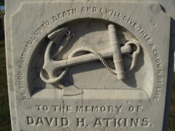
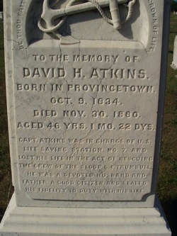
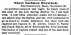
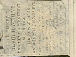
| Description | : | Capt. David H. Atkins was in charge of the U.S. Life Saving Station No. 7 and lost his life in the act of rescuing the crew of the sloop C.E. Trumbull. He was a devoted husband and father, a good citizen and sealed his fidelity to duty with his life. His Epitaph : Be Thou Faithful Unto Death and I Will Give Thee A Crown Of Life. Keeper Atkins and two of his crew died trying to assist the sloop C. E. Trumbull, with a cargo of coal for ballast and a crew of six, when she stranded in a violent... Read More |
frequently asked questions (FAQ):
-
Where is Capt David H. Atkins's memorial?
Capt David H. Atkins's memorial is located at: Saint Mary's Cemetery, Omaha, Douglas County, USA.
-
When did Capt David H. Atkins death?
Capt David H. Atkins death on 30 Nov 1880 in Provincetown, Barnstable County, Massachusetts, USA
-
Where are the coordinates of the Capt David H. Atkins's memorial?
Latitude: 41.2042007
Longitude: -95.9646988
Family Members:
Parent

Siblings
Flowers:


Nearby Cemetories:
1. Saint Mary's Cemetery
Omaha, Douglas County, USA
Coordinate: 41.2042007, -95.9646988
2. Graceland Park Cemetery
Omaha, Douglas County, USA
Coordinate: 41.2113991, -95.9785995
3. Saint Mary Magdalene Cemetery
Omaha, Douglas County, USA
Coordinate: 41.2039420, -95.9850610
4. Saint Johns Cemetery
Bellevue, Sarpy County, USA
Coordinate: 41.1864014, -95.9682999
5. Laurel Hill Cemetery
Omaha, Douglas County, USA
Coordinate: 41.1918983, -95.9417038
6. Fisher Farm Cemetery
Bellevue, Sarpy County, USA
Coordinate: 41.1727982, -95.9760971
7. Hrabik Cemetery
Bellevue, Sarpy County, USA
Coordinate: 41.1726540, -95.9768200
8. Westlawn-Hillcrest Memorial Park
Omaha, Douglas County, USA
Coordinate: 41.2346992, -95.9966965
9. Douglas County Poor Farm Cemetery
Omaha, Douglas County, USA
Coordinate: 41.2437240, -95.9723480
10. Bohemian Cemetery
Omaha, Douglas County, USA
Coordinate: 41.2388992, -95.9955978
11. First Central Congregational Columbarium
Omaha, Douglas County, USA
Coordinate: 41.2563456, -95.9658365
12. Holy Sepulchre Cemetery
Omaha, Douglas County, USA
Coordinate: 41.2543983, -95.9875031
13. Ak-Sar-Ben Racetrack Grounds
Omaha, Douglas County, USA
Coordinate: 41.2414703, -96.0159607
14. Immanuel Lutheran Church Columbarium
Bellevue, Sarpy County, USA
Coordinate: 41.1602700, -95.9218900
15. Calvary Cemetery
Omaha, Douglas County, USA
Coordinate: 41.2364006, -96.0294037
16. Beth El Cemetery
Ralston, Douglas County, USA
Coordinate: 41.2117004, -96.0428009
17. Trinity Cathedral Columbarium
Omaha, Douglas County, USA
Coordinate: 41.2603900, -95.9393660
18. Resurrection Cemetery
Omaha, Douglas County, USA
Coordinate: 41.2344208, -96.0365448
19. Nash Chapel Crypt
Omaha, Douglas County, USA
Coordinate: 41.2665090, -95.9721790
20. Evergreen Memorial Park Cemetery
Omaha, Douglas County, USA
Coordinate: 41.2393990, -96.0355988
21. Papillion Cemetery
Papillion, Sarpy County, USA
Coordinate: 41.1758003, -96.0410995
22. Church of the Holy Spirit Columbarium
Bellevue, Sarpy County, USA
Coordinate: 41.1475000, -95.9244000
23. Council Point Cemetery
Council Bluffs, Pottawattamie County, USA
Coordinate: 41.2110830, -95.8788610
24. Tunison Cemetery
Bellevue, Sarpy County, USA
Coordinate: 41.1357570, -95.9481150