
| Memorials | : | 22 |
| Location | : | Council Bluffs, Pottawattamie County, USA |
| Coordinate | : | 41.2110830, -95.8788610 |
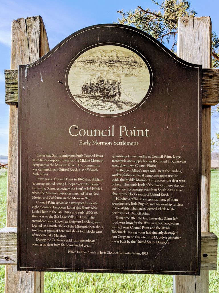
| Description | : | 41 12' 39.9" N, 095 52' 43.9 W (Council Point Marker) Cemetery at Council Point Washed Into the River "At Council Point, west of Manawa, a settlement of Mormons started a cemetery in 1848. A large number of them were buried there while the Mormons occupied this section of the country. After the cemetery was abandoned it was in after years washed into the river, and the exact location of it could hardly be determined at this date. The following death information is taken from death and marriage notices from the Frontier Guardian newspaper of the Kanesville area from 1849 - 1852: Allred, John... Read More |
frequently asked questions (FAQ):
-
Where is Council Point Cemetery?
Council Point Cemetery is located at Council Bluffs, Pottawattamie County ,Iowa ,USA.
-
Council Point Cemetery cemetery's updated grave count on graveviews.com?
22 memorials
-
Where are the coordinates of the Council Point Cemetery?
Latitude: 41.2110830
Longitude: -95.8788610
Nearby Cemetories:
1. Maple Grove Cemetery
Council Bluffs, Pottawattamie County, USA
Coordinate: 41.2265560, -95.8187100
2. Fontenelle Forest Cemetery
Bellevue, Sarpy County, USA
Coordinate: 41.1636430, -95.8887200
3. Laurel Hill Cemetery
Omaha, Douglas County, USA
Coordinate: 41.1918983, -95.9417038
4. Immanuel Lutheran Church Columbarium
Bellevue, Sarpy County, USA
Coordinate: 41.1602700, -95.9218900
5. Clark Cemetery
Pottawattamie County, USA
Coordinate: 41.2551610, -95.8223390
6. Saint Marys Cemetery
Mills County, USA
Coordinate: 41.1517580, -95.8514000
7. Bellevue Cemetery
Bellevue, Sarpy County, USA
Coordinate: 41.1492004, -95.8944016
8. Fairview Cemetery
Council Bluffs, Pottawattamie County, USA
Coordinate: 41.2703018, -95.8480988
9. Lewis Township Cemetery
Council Bluffs, Pottawattamie County, USA
Coordinate: 41.2117004, -95.7938995
10. Saint Mary's Cemetery
Omaha, Douglas County, USA
Coordinate: 41.2042007, -95.9646988
11. Memorial Park Cemetery
Council Bluffs, Pottawattamie County, USA
Coordinate: 41.2644005, -95.8261032
12. Trinity Cathedral Columbarium
Omaha, Douglas County, USA
Coordinate: 41.2603900, -95.9393660
13. Ridgewood Cemetery
Council Bluffs, Pottawattamie County, USA
Coordinate: 41.2694016, -95.8272018
14. Moscrip Cemetery
Bellevue, Sarpy County, USA
Coordinate: 41.1413500, -95.8917000
15. Saint Johns Cemetery
Bellevue, Sarpy County, USA
Coordinate: 41.1864014, -95.9682999
16. Church of the Holy Spirit Columbarium
Bellevue, Sarpy County, USA
Coordinate: 41.1475000, -95.9244000
17. Oak Hill Cemetery
Council Bluffs, Pottawattamie County, USA
Coordinate: 41.2700900, -95.8226400
18. Bikhor Cholim Cemetery
Council Bluffs, Pottawattamie County, USA
Coordinate: 41.2703670, -95.8229350
19. Walnut Hill Cemetery
Council Bluffs, Pottawattamie County, USA
Coordinate: 41.2719002, -95.8255997
20. Columban Martyrs Memorial Garden
Bellevue, Sarpy County, USA
Coordinate: 41.1403220, -95.9034390
21. Cedar Lawn Cemetery
Council Bluffs, Pottawattamie County, USA
Coordinate: 41.2694016, -95.8182983
22. Graceland Park Cemetery
Omaha, Douglas County, USA
Coordinate: 41.2113991, -95.9785995
23. Saint Joseph Cemetery
Council Bluffs, Pottawattamie County, USA
Coordinate: 41.2722015, -95.8208008
24. Green Valley Cemetery
Council Bluffs, Pottawattamie County, USA
Coordinate: 41.2743988, -95.8225021