
| Birth | : | 16 Mar 1762 Salem, Essex County, Massachusetts, USA |
| Death | : | 6 May 1826 Yarmouth, Yarmouth County, Nova Scotia, Canada |
| Burial | : | Makaraka Cemetery, Gisborne, Gisborne District, New Zealand |
| Coordinate | : | -38.6482600, 177.9803200 |
| Plot | : | Mountain Cemetery West |
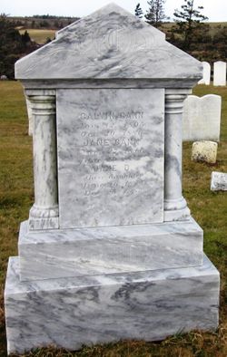
| Inscription | : | "In Memory of John Cann who departed this life the 6th May 1826 aged 65 years." Click on photo to see inscription and description of the marker. |
| Description | : | Yarmouth records call him John Cann 1st of Yarmouth, though in our family he was the fifth John Cann- son of John Cann IV and Elizabeth Ellenwood. He was a Schooner Captain. Married Thankful in Yarmouth. He inherited the House of Seven Gables in Salem. A Tory (See "Forest of Trees: Loyalist Descendants of New Brunswick and Maine") |
frequently asked questions (FAQ):
-
Where is Capt. John Cann Sr.'s memorial?
Capt. John Cann Sr.'s memorial is located at: Makaraka Cemetery, Gisborne, Gisborne District, New Zealand.
-
When did Capt. John Cann Sr. death?
Capt. John Cann Sr. death on 6 May 1826 in Yarmouth, Yarmouth County, Nova Scotia, Canada
-
Where are the coordinates of the Capt. John Cann Sr.'s memorial?
Latitude: -38.6482600
Longitude: 177.9803200
Family Members:
Spouse

Children
Flowers:


Nearby Cemetories:
1. Makaraka Cemetery
Gisborne, Gisborne District, New Zealand
Coordinate: -38.6482600, 177.9803200
2. Taruheru Cemetery
Gisborne, Gisborne District, New Zealand
Coordinate: -38.6428900, 177.9802300
3. Opou Tuarakena Cemetery
Manutuke, Gisborne District, New Zealand
Coordinate: -38.6744759, 177.9095277
4. Opou Station Cemetery
Manutuke, Gisborne District, New Zealand
Coordinate: -38.6779310, 177.9084450
5. Manutuke Churchyard Urupā
Manutuke, Gisborne District, New Zealand
Coordinate: -38.6815360, 177.9080180
6. Manutuke Whakato Urupā
Manutuke, Gisborne District, New Zealand
Coordinate: -38.6843390, 177.9073690
7. Waerenga a hika Urupā
Gisborne, Gisborne District, New Zealand
Coordinate: -38.5954100, 177.9263500
8. Patutahi Cemetery
Gisborne, Gisborne District, New Zealand
Coordinate: -38.6199300, 177.8955600
9. Paramanihi Waihirere Cemetery
Gisborne, Gisborne District, New Zealand
Coordinate: -38.5791250, 177.9488450
10. Wainui
Gisborne District, New Zealand
Coordinate: -38.6950000, 178.0707400
11. Ormond Cemetery
Ormond, Gisborne District, New Zealand
Coordinate: -38.5526480, 177.9279330
12. Pouawa Urupā
Whangara, Gisborne District, New Zealand
Coordinate: -38.6085500, 178.1825900
13. Whangara Urupā
Whangara, Gisborne District, New Zealand
Coordinate: -38.5716800, 178.2310400
14. Tapuae o te Rangi Urupā
Whatatutu, Gisborne District, New Zealand
Coordinate: -38.3791200, 177.8134180
15. Nuhaka North Cemetery
Morere, Wairoa District, New Zealand
Coordinate: -38.9797100, 177.7944300
16. Kohimarama Urupā
Tolaga Bay, Gisborne District, New Zealand
Coordinate: -38.3791770, 178.3007610
17. Tolaga Bay Cemetery
Tolaga Bay, Gisborne District, New Zealand
Coordinate: -38.3643370, 178.3045240
18. Tolaga Bay Urupā
Tolaga Bay, Gisborne District, New Zealand
Coordinate: -38.3629400, 178.3050080
19. Rakauroa Cemetery
Matawai, Gisborne District, New Zealand
Coordinate: -38.4358900, 177.5711400
20. Okuri Marea Urupa
Tolaga Bay, Gisborne District, New Zealand
Coordinate: -38.3055250, 178.2704340
21. Arataiha Urupā
Nuhaka, Wairoa District, New Zealand
Coordinate: -39.0201020, 177.7361770
22. Opoutama Cemetery
Mahia, Wairoa District, New Zealand
Coordinate: -39.0550780, 177.8405420
23. Manawarakau Urupā
Nuhaka, Wairoa District, New Zealand
Coordinate: -39.0371870, 177.7262650
24. Kaiuku Marae Urupā
Mahia, Wairoa District, New Zealand
Coordinate: -39.0823112, 177.9086516