
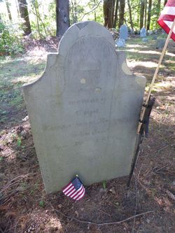
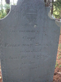
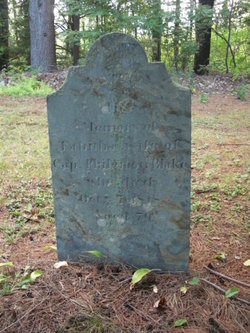
Capt Philemon Blake
| Birth | : | 1738 |
| Death | : | 10 Jan 1826 Rockingham County, New Hampshire, USA |
| Burial | : | Christ Church Churchyard, Nailsea, North Somerset Unitary Authority, England |
| Coordinate | : | 51.4336490, -2.7612050 |
| Plot | : | 156 |
| Inscription | : | "In memory of Capt Philemon Blake, who died Jan, 10th, 1826, in his 88th year." |
| Description | : | Son of Philemon (1705/6 - 1788) and Lydia (Boulter) Blake and the grandson of Philemon (1671 - about 1741) and Sarah (Dearborn) Blake, both of Hampton. Husband of Tabitha Tuck. Philemon Blake Cemetery: Old Cem Location: Kensington NH 29 Reference: Abstract of Graves of Revolutionary Patriots, Vol.1, p. Serial: 9200; Volume: 3 |
frequently asked questions (FAQ):
-
Where is Capt Philemon Blake's memorial?
Capt Philemon Blake's memorial is located at: Christ Church Churchyard, Nailsea, North Somerset Unitary Authority, England.
-
When did Capt Philemon Blake death?
Capt Philemon Blake death on 10 Jan 1826 in Rockingham County, New Hampshire, USA
-
Where are the coordinates of the Capt Philemon Blake's memorial?
Latitude: 51.4336490
Longitude: -2.7612050
Family Members:
Parent
Spouse
Siblings
Children
Flowers:


Nearby Cemetories:
1. Christ Church Churchyard
Nailsea, North Somerset Unitary Authority, England
Coordinate: 51.4336490, -2.7612050
2. Nailsea Garden of Rest
Nailsea, North Somerset Unitary Authority, England
Coordinate: 51.4340540, -2.7613880
3. Holy Trinity Churchyard
Nailsea, North Somerset Unitary Authority, England
Coordinate: 51.4258140, -2.7692830
4. Ss Quiricus & Julietta Churchyard
Tickenham, North Somerset Unitary Authority, England
Coordinate: 51.4394000, -2.7814000
5. All Saints Churchyard
Wraxall, North Somerset Unitary Authority, England
Coordinate: 51.4444000, -2.7348000
6. Saint Bridget's Churchyard
Chelvey, North Somerset Unitary Authority, England
Coordinate: 51.4117570, -2.7689680
7. Saint Michael Churchyard
Clapton-in-Gordano, North Somerset Unitary Authority, England
Coordinate: 51.4583000, -2.7673000
8. St. Andrew's Churchyard
Backwell, North Somerset Unitary Authority, England
Coordinate: 51.4118600, -2.7297400
9. Tyntesfield House Chapel
Wraxall, North Somerset Unitary Authority, England
Coordinate: 51.4407400, -2.7110500
10. St Michael & All Angels
Flax Bourton, North Somerset Unitary Authority, England
Coordinate: 51.4212620, -2.7109840
11. St. Nicholas' Churchyard
Brockley, North Somerset Unitary Authority, England
Coordinate: 51.3988950, -2.7686830
12. Portishead Cemetery
Portishead, North Somerset Unitary Authority, England
Coordinate: 51.4720380, -2.7737220
13. St Peter & St Paul Churchyard
Weston-in-Gordano, North Somerset Unitary Authority, England
Coordinate: 51.4642080, -2.8017420
14. Ss Mary and Edward Churchyard
Barrow Gurney, North Somerset Unitary Authority, England
Coordinate: 51.4130630, -2.6989510
15. Holy Trinity Churchyard
Cleeve, North Somerset Unitary Authority, England
Coordinate: 51.3908200, -2.7773600
16. St. Bartholomew's Churchyard
Failand, North Somerset Unitary Authority, England
Coordinate: 51.4584000, -2.7000000
17. St. Paul's Churchyard
Walton-in-Gordano, North Somerset Unitary Authority, England
Coordinate: 51.4542810, -2.8287060
18. Saint Peter Churchyard
Portishead, North Somerset Unitary Authority, England
Coordinate: 51.4806130, -2.7709270
19. Saint Mary's the Virgin Churchyard
Portbury, North Somerset Unitary Authority, England
Coordinate: 51.4756000, -2.7173000
20. All Saints Churchyard
Clevedon, North Somerset Unitary Authority, England
Coordinate: 51.4427000, -2.8406000
21. Saint John the Evangelist Churchyard
Kenn, North Somerset Unitary Authority, England
Coordinate: 51.4168000, -2.8413000
22. Saint George Churchyard
Easton-in-Gordano, North Somerset Unitary Authority, England
Coordinate: 51.4785490, -2.7013400
23. St. Mary's Churchyard
Clevedon, North Somerset Unitary Authority, England
Coordinate: 51.4495200, -2.8514000
24. St. Mary's Churchyard
Yatton, North Somerset Unitary Authority, England
Coordinate: 51.3847720, -2.8185510