
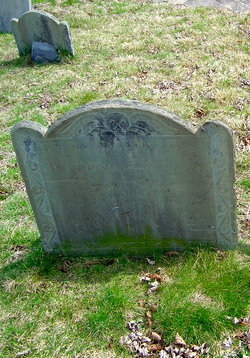
Capt Samuel Stevens
| Birth | : | 30 Mar 1682 Massachusetts, USA |
| Death | : | 23 Feb 1768 Roxbury, Suffolk County, Massachusetts, USA |
| Burial | : | Graceland Cemetery, Albert Lea, Freeborn County, USA |
| Coordinate | : | 43.6491699, -93.3930588 |
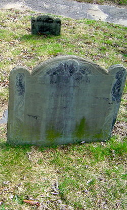
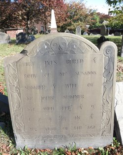
| Inscription | : | Here lie the Body of Capt. SAMUEL STEVENS who Departed this life Feb. 23d 1768 Aged 85 Years. |
| Description | : | Married May 25, 1708 Married Oct 9, 1712 Thanks to FAG 47312104 for place of Burial and grave transcription/picture of tombstones |
frequently asked questions (FAQ):
-
Where is Capt Samuel Stevens's memorial?
Capt Samuel Stevens's memorial is located at: Graceland Cemetery, Albert Lea, Freeborn County, USA.
-
When did Capt Samuel Stevens death?
Capt Samuel Stevens death on 23 Feb 1768 in Roxbury, Suffolk County, Massachusetts, USA
-
Where are the coordinates of the Capt Samuel Stevens's memorial?
Latitude: 43.6491699
Longitude: -93.3930588
Family Members:
Parent
Spouse
Siblings
Children
Flowers:


Nearby Cemetories:
1. Graceland Cemetery
Albert Lea, Freeborn County, USA
Coordinate: 43.6491699, -93.3930588
2. Lakewood Cemetery
Albert Lea, Freeborn County, USA
Coordinate: 43.6591682, -93.3694382
3. Saint Theodores Cemetery
Albert Lea, Freeborn County, USA
Coordinate: 43.6611099, -93.3705597
4. Itasca Cemetery
Albert Lea, Freeborn County, USA
Coordinate: 43.6758499, -93.4035721
5. Shady Oak Cemetery
Conger, Freeborn County, USA
Coordinate: 43.6166687, -93.4452820
6. Poor Farm Cemetery
Bancroft, Freeborn County, USA
Coordinate: 43.7013466, -93.3613213
7. Hillcrest Cemetery
Albert Lea, Freeborn County, USA
Coordinate: 43.6100006, -93.3343964
8. Central Freeborn Lutheran Cemetery
Albert Lea, Freeborn County, USA
Coordinate: 43.7088890, -93.3819427
9. Concordia Pickerel Lake Cemetery
Conger, Freeborn County, USA
Coordinate: 43.6300011, -93.4805603
10. Lunder Lutheran Cemetery
Twin Lakes, Freeborn County, USA
Coordinate: 43.5750008, -93.3977814
11. Green Cemetery
Twin Lakes, Freeborn County, USA
Coordinate: 43.5758743, -93.3619156
12. Glenville First Lutheran Cemetery
Glenville, Freeborn County, USA
Coordinate: 43.6002808, -93.3088913
13. East Freeborn Lutheran Church Cemetery
Lerdal, Freeborn County, USA
Coordinate: 43.7008286, -93.2991714
14. Bear Lake Cemetery
Freeborn County, USA
Coordinate: 43.5787354, -93.4795990
15. Conger Community Cemetery
Conger, Freeborn County, USA
Coordinate: 43.6158295, -93.5183334
16. North Round Prairie Cemetery
Glenville, Freeborn County, USA
Coordinate: 43.5531006, -93.3649979
17. Hayward Cemetery
Hayward, Freeborn County, USA
Coordinate: 43.6445618, -93.2436066
18. Brush Hill Cemetery
Twin Lakes, Freeborn County, USA
Coordinate: 43.5491982, -93.4580994
19. Round Prairie Cemetery
Glenville, Freeborn County, USA
Coordinate: 43.5411987, -93.3529968
20. Saint James Cemetery
Twin Lakes, Freeborn County, USA
Coordinate: 43.5346985, -93.4178009
21. West Freeborn Cemetery
Manchester, Freeborn County, USA
Coordinate: 43.7494011, -93.4783020
22. Greenwood Cemetery
Glenville, Freeborn County, USA
Coordinate: 43.5727997, -93.2675018
23. Clarks Grove Baptist Cemetery
Clarks Grove, Freeborn County, USA
Coordinate: 43.7677994, -93.3097000
24. Riceland Cemetery
Hollandale, Freeborn County, USA
Coordinate: 43.7376175, -93.2476654