
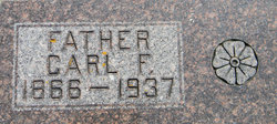
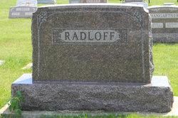
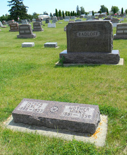
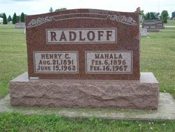
Carl Friedrich Henry Radloff
| Birth | : | 26 Jun 1866 Germany |
| Death | : | 6 Nov 1937 Postville, Allamakee County, Iowa, USA |
| Burial | : | Edgworth Congregational Chapelyard, Edgworth, Blackburn with Darwen Unitary Authority, England |
| Coordinate | : | 53.6476280, -2.3967210 |
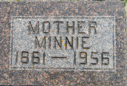
| Description | : | Thursday, 11 Nov. 1937, Postville Herald, p1, c4: Chas. F. Radloff Passes Saturday _______ Funeral Services Were Held Here On Tuesday _______ Carl Friederich Henry Radloff was born in Blesewitz, Germany, June 26, 1866, the son of Mr. and Mrs. Carl Radloff. Shortly after birth he was baptized and later became a communicant member of the Lutheran church of his native land by rite of confirmation. He came to this country at the age of seven years. On January 31, 1889, he was united in marriage with Miss Minna Schmidt. They first settled on a farm near Elkader, where they... Read More |
frequently asked questions (FAQ):
-
Where is Carl Friedrich Henry Radloff's memorial?
Carl Friedrich Henry Radloff's memorial is located at: Edgworth Congregational Chapelyard, Edgworth, Blackburn with Darwen Unitary Authority, England.
-
When did Carl Friedrich Henry Radloff death?
Carl Friedrich Henry Radloff death on 6 Nov 1937 in Postville, Allamakee County, Iowa, USA
-
Where are the coordinates of the Carl Friedrich Henry Radloff's memorial?
Latitude: 53.6476280
Longitude: -2.3967210
Family Members:
Spouse
Children
Flowers:


Nearby Cemetories:
1. Methodist Church Churchyard
Edgworth, Blackburn with Darwen Unitary Authority, England
Coordinate: 53.6424280, -2.3962830
2. St. Anne's Churchyard
Chapeltown, Blackburn with Darwen Unitary Authority, England
Coordinate: 53.6371710, -2.4030440
3. Hawkshaw Methodist Church Cemetery
Hawkshaw, Metropolitan Borough of Bury, England
Coordinate: 53.6313490, -2.3674190
4. St Mary Churchyard
Hawkshaw, Metropolitan Borough of Bury, England
Coordinate: 53.6307270, -2.3636210
5. Congregational Churchyard
Affetside, Metropolitan Borough of Bury, England
Coordinate: 53.6175200, -2.3705800
6. Christ Church Churchyard
Egerton, Metropolitan Borough of Bolton, England
Coordinate: 53.6237080, -2.4389210
7. Tottington Road Methodist Church Churchyard
Harwood, Metropolitan Borough of Bolton, England
Coordinate: 53.6079190, -2.3904960
8. Emmanuel Churchyard
Holcombe, Metropolitan Borough of Bury, England
Coordinate: 53.6463000, -2.3293400
9. Greenmount United Reformed Churchyard
Greenmount, Metropolitan Borough of Bury, England
Coordinate: 53.6254581, -2.3381465
10. St. Maxentius Churchyard
Bradshaw, Metropolitan Borough of Bolton, England
Coordinate: 53.6056800, -2.4014800
11. Ramsbottom Cemetery
Ramsbottom, Metropolitan Borough of Bury, England
Coordinate: 53.6372986, -2.3271000
12. Harwood Methodist Church Cemetery
Harwood, Metropolitan Borough of Bolton, England
Coordinate: 53.6028240, -2.3903990
13. Darwen Eastern Cemetery
Darwen, Blackburn with Darwen Unitary Authority, England
Coordinate: 53.6769300, -2.4547700
14. St Anne Churchyard
Tottington, Metropolitan Borough of Bury, England
Coordinate: 53.6161499, -2.3409030
15. St. John's Churchyard
Tottington, Metropolitan Borough of Bury, England
Coordinate: 53.6141180, -2.3400670
16. Darwen Cemetery
Darwen, Blackburn with Darwen Unitary Authority, England
Coordinate: 53.6781400, -2.4598300
17. St Paul Churchyard
Astley Bridge, Metropolitan Borough of Bolton, England
Coordinate: 53.5996230, -2.4314330
18. Stubbins Congregational Chapelyard
Rossendale Borough, England
Coordinate: 53.6626600, -2.3110700
19. Christ Church Churchyard
Harwood, Metropolitan Borough of Bolton, England
Coordinate: 53.5948860, -2.3821990
20. Bolton Cemetery
Astley Bridge, Metropolitan Borough of Bolton, England
Coordinate: 53.5989150, -2.4370830
21. Rowlands Methodist Churchyard
Summerseat, Metropolitan Borough of Bury, England
Coordinate: 53.6294360, -2.3102920
22. St. Paul's Churchyard
Darwen, Blackburn with Darwen Unitary Authority, England
Coordinate: 53.6979270, -2.4318640
23. Pickup Bank Congregational Chapel
Pickup Bank, Blackburn with Darwen Unitary Authority, England
Coordinate: 53.7012440, -2.4164220
24. St. John-in-the-Wilderness Churchyard
Shuttleworth, Metropolitan Borough of Bury, England
Coordinate: 53.6556300, -2.3046500