

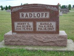
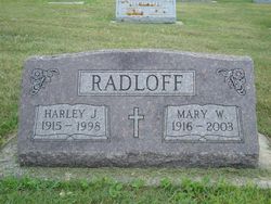
Henry C Radloff
| Birth | : | 21 Aug 1891 Clayton County, Iowa, USA |
| Death | : | 15 Jun 1962 Charles City, Floyd County, Iowa, USA |
| Burial | : | Edgworth Congregational Chapelyard, Edgworth, Blackburn with Darwen Unitary Authority, England |
| Coordinate | : | 53.6476280, -2.3967210 |
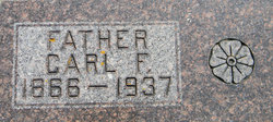
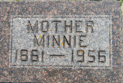
| Description | : | Rites Held For Henry Radloff Henry C. Radloff, the son of Charles F. Radloff and his wife, Minnie Schmidt Radloff, was born August 21, 1891 in Clayton county, Iowa. He was baptized at Zion Lutheran Church, Clayton Center, on April 7, 1892 and confirmed at St. John's Lutheran Church, Luana, April 16, 1905. He died at the Cedar Valley Hospital in Charles City, on June 15, 1962 at the age of 70 years, nine months and 24 days. He had been a patient at the Cedar Valley Hospital since June 11, following an automobile accident while enroute to Postville. He... Read More |
frequently asked questions (FAQ):
-
Where is Henry C Radloff's memorial?
Henry C Radloff's memorial is located at: Edgworth Congregational Chapelyard, Edgworth, Blackburn with Darwen Unitary Authority, England.
-
When did Henry C Radloff death?
Henry C Radloff death on 15 Jun 1962 in Charles City, Floyd County, Iowa, USA
-
Where are the coordinates of the Henry C Radloff's memorial?
Latitude: 53.6476280
Longitude: -2.3967210
Family Members:
Parent
Spouse
Siblings
Children
Flowers:


Nearby Cemetories:
1. Methodist Church Churchyard
Edgworth, Blackburn with Darwen Unitary Authority, England
Coordinate: 53.6424280, -2.3962830
2. St. Anne's Churchyard
Chapeltown, Blackburn with Darwen Unitary Authority, England
Coordinate: 53.6371710, -2.4030440
3. Hawkshaw Methodist Church Cemetery
Hawkshaw, Metropolitan Borough of Bury, England
Coordinate: 53.6313490, -2.3674190
4. St Mary Churchyard
Hawkshaw, Metropolitan Borough of Bury, England
Coordinate: 53.6307270, -2.3636210
5. Congregational Churchyard
Affetside, Metropolitan Borough of Bury, England
Coordinate: 53.6175200, -2.3705800
6. Christ Church Churchyard
Egerton, Metropolitan Borough of Bolton, England
Coordinate: 53.6237080, -2.4389210
7. Tottington Road Methodist Church Churchyard
Harwood, Metropolitan Borough of Bolton, England
Coordinate: 53.6079190, -2.3904960
8. Emmanuel Churchyard
Holcombe, Metropolitan Borough of Bury, England
Coordinate: 53.6463000, -2.3293400
9. Greenmount United Reformed Churchyard
Greenmount, Metropolitan Borough of Bury, England
Coordinate: 53.6254581, -2.3381465
10. St. Maxentius Churchyard
Bradshaw, Metropolitan Borough of Bolton, England
Coordinate: 53.6056800, -2.4014800
11. Ramsbottom Cemetery
Ramsbottom, Metropolitan Borough of Bury, England
Coordinate: 53.6372986, -2.3271000
12. Harwood Methodist Church Cemetery
Harwood, Metropolitan Borough of Bolton, England
Coordinate: 53.6028240, -2.3903990
13. Darwen Eastern Cemetery
Darwen, Blackburn with Darwen Unitary Authority, England
Coordinate: 53.6769300, -2.4547700
14. St Anne Churchyard
Tottington, Metropolitan Borough of Bury, England
Coordinate: 53.6161499, -2.3409030
15. St. John's Churchyard
Tottington, Metropolitan Borough of Bury, England
Coordinate: 53.6141180, -2.3400670
16. Darwen Cemetery
Darwen, Blackburn with Darwen Unitary Authority, England
Coordinate: 53.6781400, -2.4598300
17. St Paul Churchyard
Astley Bridge, Metropolitan Borough of Bolton, England
Coordinate: 53.5996230, -2.4314330
18. Stubbins Congregational Chapelyard
Rossendale Borough, England
Coordinate: 53.6626600, -2.3110700
19. Christ Church Churchyard
Harwood, Metropolitan Borough of Bolton, England
Coordinate: 53.5948860, -2.3821990
20. Bolton Cemetery
Astley Bridge, Metropolitan Borough of Bolton, England
Coordinate: 53.5989150, -2.4370830
21. Rowlands Methodist Churchyard
Summerseat, Metropolitan Borough of Bury, England
Coordinate: 53.6294360, -2.3102920
22. St. Paul's Churchyard
Darwen, Blackburn with Darwen Unitary Authority, England
Coordinate: 53.6979270, -2.4318640
23. Pickup Bank Congregational Chapel
Pickup Bank, Blackburn with Darwen Unitary Authority, England
Coordinate: 53.7012440, -2.4164220
24. St. John-in-the-Wilderness Churchyard
Shuttleworth, Metropolitan Borough of Bury, England
Coordinate: 53.6556300, -2.3046500