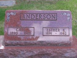
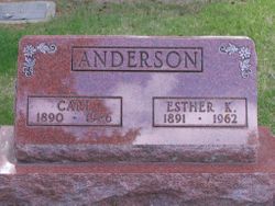
Carl K. Anderson
| Birth | : | 19 Apr 1890 Spink County, South Dakota, USA |
| Death | : | 20 Apr 1986 Redfield, Spink County, South Dakota, USA |
| Burial | : | Mount Vernon Cemetery, Peru, Nemaha County, USA |
| Coordinate | : | 40.4768982, -95.7208023 |
| Plot | : | Division F, Block 044, Grave 003 |
| Description | : | Buried at Greenlawn Cemetery on April 23, 1986. |
frequently asked questions (FAQ):
-
Where is Carl K. Anderson's memorial?
Carl K. Anderson's memorial is located at: Mount Vernon Cemetery, Peru, Nemaha County, USA.
-
When did Carl K. Anderson death?
Carl K. Anderson death on 20 Apr 1986 in Redfield, Spink County, South Dakota, USA
-
Where are the coordinates of the Carl K. Anderson's memorial?
Latitude: 40.4768982
Longitude: -95.7208023
Family Members:
Parent
Spouse
Siblings
Children
Flowers:
Nearby Cemetories:
1. Mount Vernon Cemetery
Peru, Nemaha County, USA
Coordinate: 40.4768982, -95.7208023
2. Honey Creek Cemetery
Nemaha Township, Nemaha County, USA
Coordinate: 40.4430199, -95.6980820
3. Sonora Cemetery
Watson, Atchison County, USA
Coordinate: 40.4730988, -95.6521988
4. Karn Cemetery
Glenrock, Nemaha County, USA
Coordinate: 40.4789000, -95.7917000
5. London Cemetery
Peru, Nemaha County, USA
Coordinate: 40.4225006, -95.7621994
6. Highland Methodist Cemetery
Nemaha County, USA
Coordinate: 40.4581850, -95.8097140
7. Highland Baptist Cemetery
Auburn, Nemaha County, USA
Coordinate: 40.4578018, -95.8191986
8. Walnut Grove Cemetery
Brownville, Nemaha County, USA
Coordinate: 40.4023056, -95.6642990
9. Kinser Burial Site
Watson, Atchison County, USA
Coordinate: 40.4974350, -95.5908610
10. Addington Cemetery
Watson, Atchison County, USA
Coordinate: 40.4721985, -95.5828018
11. Clayton-Lewis Cemetery
Rock Port, Atchison County, USA
Coordinate: 40.5439730, -95.6102280
12. Saint Bernards Church Cemetery
Julian, Nemaha County, USA
Coordinate: 40.5078000, -95.8592000
13. Camp Creek Cemetery
Otoe County, USA
Coordinate: 40.5681000, -95.8019028
14. Glenrock Cemetery
Glenrock, Nemaha County, USA
Coordinate: 40.4644012, -95.8764038
15. High Creek Cemetery
Rock Port, Atchison County, USA
Coordinate: 40.5086780, -95.5690380
16. Union Cemetery
Rock Port, Atchison County, USA
Coordinate: 40.5685000, -95.6110000
17. Stoner Cemetery
Atchison County, USA
Coordinate: 40.5127983, -95.5618973
18. Sheridan Cemetery
Auburn, Nemaha County, USA
Coordinate: 40.3936005, -95.8591995
19. Klaus Burial Site
Watson, Atchison County, USA
Coordinate: 40.4917400, -95.5440620
20. Nemaha Cemetery
Nemaha, Nemaha County, USA
Coordinate: 40.3469009, -95.6596985
21. Linden Cemetery
Watson, Atchison County, USA
Coordinate: 40.4856130, -95.5383220
22. Millsap Cemetery
Rock Port, Atchison County, USA
Coordinate: 40.4150009, -95.5532990
23. Sheridan West Memorial Cemetery
Auburn, Nemaha County, USA
Coordinate: 40.3920580, -95.8701320
24. Lansdown family burial site
Rock Port, Atchison County, USA
Coordinate: 40.4154319, -95.5522575

