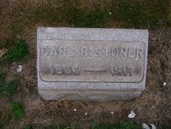
Carl Ruth Stoner
| Birth | : | 19 Jan 1886 Westmoreland County, Pennsylvania, USA |
| Death | : | 15 May 1917 Westmoreland County, Pennsylvania, USA |
| Burial | : | Alverton Cemetery, Alverton, Westmoreland County, USA |
| Coordinate | : | 40.1410000, -79.5890000 |
| Plot | : | D 40-1 |
| Description | : | Carl R. Stoner, 31 years old, a well known West Penn conductor on the main line, died this morning at 9 o'clock at his home in the corner of Crawford avenue and Eleventh street, West Side, following an illness of a complication of diseases dating back to April 1, last. Short services will be held from the home Thursday atrernoon at 1 o'clock, after which the funeral party, in charge of Funeral Director Charles C. Mitchell, will leave on a special street car for Alverton, where services will be held at the Church of God. Rev. J.S. Showers, pastor of... Read More |
frequently asked questions (FAQ):
-
Where is Carl Ruth Stoner's memorial?
Carl Ruth Stoner's memorial is located at: Alverton Cemetery, Alverton, Westmoreland County, USA.
-
When did Carl Ruth Stoner death?
Carl Ruth Stoner death on 15 May 1917 in Westmoreland County, Pennsylvania, USA
-
Where are the coordinates of the Carl Ruth Stoner's memorial?
Latitude: 40.1410000
Longitude: -79.5890000
Family Members:
Parent
Spouse
Siblings
Children
Flowers:
Nearby Cemetories:
1. Alverton Cemetery
Alverton, Westmoreland County, USA
Coordinate: 40.1410000, -79.5890000
2. Mount Zion Lutheran and Reformed Cemetery
Mayfield, Westmoreland County, USA
Coordinate: 40.1423035, -79.6093979
3. Zion Cemetery
Alverton, Westmoreland County, USA
Coordinate: 40.1423650, -79.6094020
4. Roman Catholic Polish Cemetery of the Transfigurat
Mount Pleasant, Westmoreland County, USA
Coordinate: 40.1558800, -79.5631700
5. Saint Pius X Cemetery
Mount Pleasant, Westmoreland County, USA
Coordinate: 40.1438200, -79.5461200
6. Visitation Parish Cemetery
Mount Pleasant, Westmoreland County, USA
Coordinate: 40.1439600, -79.5447200
7. Old United Presbyterian Graveyard
Mount Pleasant, Westmoreland County, USA
Coordinate: 40.1500824, -79.5452369
8. Mount Pleasant Cemetery
Mount Pleasant, Westmoreland County, USA
Coordinate: 40.1571999, -79.5475006
9. Fairview Church Cemetery
Hammondville, Fayette County, USA
Coordinate: 40.1169014, -79.5333023
10. Middle Presbyterian Cemetery
Mount Pleasant, Westmoreland County, USA
Coordinate: 40.1777000, -79.5309000
11. Saint Josef's Polish Catholic Cemetery
Everson, Fayette County, USA
Coordinate: 40.0830000, -79.5752000
12. Saint John's Union Cemetery
Mount Pleasant, Westmoreland County, USA
Coordinate: 40.1814000, -79.5316000
13. Greenlick Cemetery
Fayette County, USA
Coordinate: 40.1105995, -79.5194016
14. Pennsville Independent Cemetery
Connellsville, Fayette County, USA
Coordinate: 40.0844002, -79.5566711
15. Mount Joy Church Of The Brethren Cemetery
Mount Pleasant, Westmoreland County, USA
Coordinate: 40.1439000, -79.5054000
16. King Cemetery
Fayette County, USA
Coordinate: 40.0764300, -79.6005800
17. Brothers Cemetery
Fayette County, USA
Coordinate: 40.1360700, -79.5004300
18. Tyrone United Presbyterian Church Cemetery
Dawson, Fayette County, USA
Coordinate: 40.0740000, -79.6306000
19. Green Ridge Memorial Park
Connellsville, Fayette County, USA
Coordinate: 40.0682983, -79.5622025
20. Lobingier Cemetery
Mount Pleasant Township, Westmoreland County, USA
Coordinate: 40.1439030, -79.4887870
21. Stone Hill Cemetery
Hempfield Township, Westmoreland County, USA
Coordinate: 40.2220000, -79.5776000
22. Boyd Cemetery
Connellsville, Fayette County, USA
Coordinate: 40.0595000, -79.5776400
23. Mount Olive Cemetery
Connellsville, Fayette County, USA
Coordinate: 40.0645000, -79.5445000
24. Mellinger Cemetery
Mellingertown, Westmoreland County, USA
Coordinate: 40.1432050, -79.4784730


