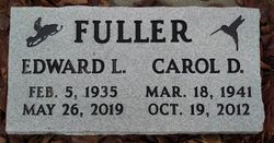
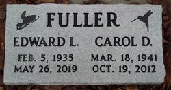
Carol Dawn Roose Fuller
| Birth | : | 18 Mar 1941 Eureka, Lincoln County, Montana, USA |
| Death | : | 19 Oct 2012 Whitefish, Flathead County, Montana, USA |
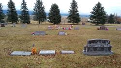
| Burial | : | Tobacco Valley Cemetery, Eureka, Lincoln County, USA |
| Coordinate | : | 48.9052600, -115.1003850 |
| Plot | : | Blk 8 ~ Lot 25 |
| Description | : | Carol D. Fuller, 71, of Eureka, died Friday, Oct. 19, 2012, at North Valley Hospital in Whitefish from natural causes. She was born March 18, 1941, in Eureka to Lester and Marie Leib Roose. She grew up and attended school in Eureka. She married Ed Fuller on Nov. 1, 1955, at the Hitching Post in Coeur D’Alene, Idaho. They made their home in the Flathead Valley for 34 years. When Ed retired in 1998 they returned to the family home in Eureka. She loved crafts of all kinds, crocheting and knitting. She was... Read More |
frequently asked questions (FAQ):
-
Where is Carol Dawn Roose Fuller's memorial?
Carol Dawn Roose Fuller's memorial is located at: Tobacco Valley Cemetery, Eureka, Lincoln County, USA.
-
When did Carol Dawn Roose Fuller death?
Carol Dawn Roose Fuller death on 19 Oct 2012 in Whitefish, Flathead County, Montana, USA
-
Where are the coordinates of the Carol Dawn Roose Fuller's memorial?
Latitude: 48.9052600
Longitude: -115.1003850
Family Members:
Spouse
Flowers:
Nearby Cemetories:
1. Tobacco Valley Cemetery
Eureka, Lincoln County, USA
Coordinate: 48.9052600, -115.1003850
2. Roosville Cemetery
Roosville, East Kootenay Regional District, Canada
Coordinate: 49.0034200, -115.0523000
3. Pine Ridge Memorial Park and Cemetery
Fortine, Lincoln County, USA
Coordinate: 48.7395840, -115.0119910
4. Fortine Cemetery
Fortine, Lincoln County, USA
Coordinate: 48.7670550, -114.8930050
5. Boyd Cemetery
Libby, Lincoln County, USA
Coordinate: 48.9543991, -115.6046982
6. Baynes Lake Cemetery
Baynes Lake, East Kootenay Regional District, Canada
Coordinate: 49.2369900, -115.2106000
7. Frank Day home burial location
Trego, Lincoln County, USA
Coordinate: 48.5841340, -114.9115700
8. Elko Cemetery
Elko, East Kootenay Regional District, Canada
Coordinate: 49.2978200, -115.1353500
9. Sand Creek Cemetery
Jaffray, East Kootenay Regional District, Canada
Coordinate: 49.3362250, -115.2909390
10. Hannah Robinson Gravesite
Morrissey, East Kootenay Regional District, Canada
Coordinate: 49.3725000, -114.9913800
11. Morrissey Cemetery
Morrissey, East Kootenay Regional District, Canada
Coordinate: 49.3751030, -114.9941990
12. Sylvanite Cemetery
Lincoln County, USA
Coordinate: 48.7210000, -115.8745000
13. Saint Margaret's Cemetery
Fernie, East Kootenay Regional District, Canada
Coordinate: 49.4989900, -115.0550900
14. Fernie Cemetery
Fernie, East Kootenay Regional District, Canada
Coordinate: 49.5002240, -115.0579050
15. East Fernie Cemetery
Fernie, East Kootenay Regional District, Canada
Coordinate: 49.5018590, -115.0566640
16. Libby Cemetery
Libby, Lincoln County, USA
Coordinate: 48.3893540, -115.5646380
17. Moyie Cemetery
Moyie, East Kootenay Regional District, Canada
Coordinate: 49.2743920, -115.8350350
18. Yahk Cemetery
Yahk, Central Kootenay Regional District, Canada
Coordinate: 49.0885510, -116.0776230
19. Winn Family Cemetery
Lincoln County, USA
Coordinate: 48.5488590, -115.9644710
20. Corbin Cemetery
Corbin, East Kootenay Regional District, Canada
Coordinate: 49.5217700, -114.6785500
21. Troy Cemetery
Troy, Lincoln County, USA
Coordinate: 48.4752330, -115.8992710
22. Milnor Lake Cemetery
Troy, Lincoln County, USA
Coordinate: 48.4181150, -115.8259500
23. Larchwood Cemetery
Lincoln County, USA
Coordinate: 48.4178009, -115.8257980
24. Hosmer Cemetery
Hosmer, East Kootenay Regional District, Canada
Coordinate: 49.5863580, -114.9565980


