
| Birth | : | 16 Nov 1877 Nebraska, USA |
| Death | : | 30 Sep 1909 Hooper, Dodge County, Nebraska, USA |
| Burial | : | Cromwell Cemetery, Cromwell, Union County, USA |
| Coordinate | : | 41.0456543, -94.4616928 |
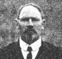
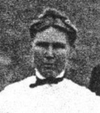
| Description | : | The Hooper Sentinel October 9, 1909 Mrs. John Schroeder Dead Hooper, Oct. 1. Mrs. John Schroeder, wife of a farmer residing eight miles north of this place died last evening at 6 o'clock after a long siege of tuberculosis. Mrs. Schroeder returned about a month ago from Colorado where she went in the hopes of benefitting her health. The deceased's maiden name was Raasch, she being the daughter of Mr. and Mrs. John Raasch of Hooper. Since her return from Colorado she had been staying with her parents, and it was at their home that the final summons came. The... Read More |
frequently asked questions (FAQ):
-
Where is Catharina E, Wilhelmina “Minnie” Raasch Schroeder's memorial?
Catharina E, Wilhelmina “Minnie” Raasch Schroeder's memorial is located at: Cromwell Cemetery, Cromwell, Union County, USA.
-
When did Catharina E, Wilhelmina “Minnie” Raasch Schroeder death?
Catharina E, Wilhelmina “Minnie” Raasch Schroeder death on 30 Sep 1909 in Hooper, Dodge County, Nebraska, USA
-
Where are the coordinates of the Catharina E, Wilhelmina “Minnie” Raasch Schroeder's memorial?
Latitude: 41.0456543
Longitude: -94.4616928
Family Members:
Parent

Spouse
Siblings
Flowers:


Nearby Cemetories:
1. Cromwell Cemetery
Cromwell, Union County, USA
Coordinate: 41.0456543, -94.4616928
2. Lytles Grove Cemetery
Cromwell, Union County, USA
Coordinate: 41.0190010, -94.4309998
3. Summit Cemetery
Prescott, Adams County, USA
Coordinate: 41.0283012, -94.5291977
4. Calvary Cemetery
Creston, Union County, USA
Coordinate: 41.0579987, -94.3899994
5. Spaulding Center Cemetery
Union County, USA
Coordinate: 41.1139984, -94.4179993
6. Graceland Cemetery
Creston, Union County, USA
Coordinate: 41.0369987, -94.3519974
7. Stringtown Cemetery
Stringtown, Adams County, USA
Coordinate: 40.9796982, -94.5663986
8. McDuffie Cemetery
Kent, Union County, USA
Coordinate: 40.9500008, -94.4110031
9. Bohemian National Cemetery
Williamson, Adams County, USA
Coordinate: 41.1152992, -94.5714035
10. Ide Cemetery
Creston, Union County, USA
Coordinate: 40.9770012, -94.3499985
11. Old Evergreen Cemetery
Prescott, Adams County, USA
Coordinate: 41.0321500, -94.6051500
12. Prairie Lawn Cemetery
Spaulding, Union County, USA
Coordinate: 41.1360016, -94.3759995
13. Rose Hill Cemetery
Nevinville, Adams County, USA
Coordinate: 41.1549988, -94.5049973
14. Mount Zion Cemetery
Adams County, USA
Coordinate: 41.0863991, -94.6031036
15. Evergreen Cemetery
Prescott, Adams County, USA
Coordinate: 41.0299988, -94.6136017
16. Grove Chapel Cemetery
Kent, Union County, USA
Coordinate: 40.9350110, -94.3947670
17. Old Jerusalem Cemetery
Creston, Union County, USA
Coordinate: 41.1159401, -94.3084335
18. Salem Cemetery
Adams County, USA
Coordinate: 40.9467010, -94.5843964
19. Morgan Cemetery
Kent, Union County, USA
Coordinate: 40.9080009, -94.4520035
20. Harmony Cemetery
Shannon City, Union County, USA
Coordinate: 40.9370003, -94.3359985
21. Bruning Cemetery
Kent, Union County, USA
Coordinate: 40.9049988, -94.4069977
22. Evergreen Cemetery
Creston, Union County, USA
Coordinate: 41.1139984, -94.2839966
23. County Home Cemetery
Creston, Union County, USA
Coordinate: 41.0449982, -94.2590027
24. Orient Cemetery
Orient, Adair County, USA
Coordinate: 41.2080002, -94.4160004