
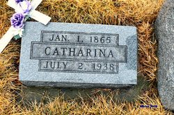
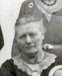
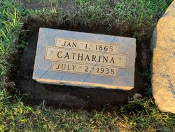
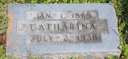
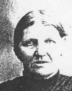
Catharina Mae Ney Drewes
| Birth | : | 1 Jan 1865 Hanover, Region Hannover, Lower Saxony (Niedersachsen), Germany |
| Death | : | 2 Jul 1938 Fayette County, Iowa, USA |
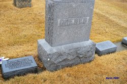
| Burial | : | Old Levin Cemetery, Levin, Horowhenua District, New Zealand |
| Coordinate | : | -40.6248570, 175.2710830 |
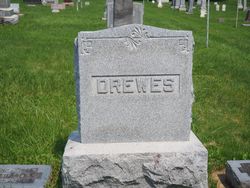
| Description | : | Katherina Ney Drewes was born Jan. 1, 1865, at Hagana, Hannover, Germany, and she spent her childhood there. In 1870 she came with her parents to America and settled near Festina, Iowa. Later the family moved to Auburn, and became members of the St. Peter Lutheran church at Eldorado, Iowa. On June 16, 1885, she was married to Claus Drewes, and they settled on a farm in Dover township about two miles south of Eldorado, Iowa. Ten children were born to this union; Anna C, Lena, Emma Kathryn, Jenny (Johanna) M., Henrietta (Hattie)Rosena, George D., Harry Diedrich, Frieda (Rita),... Read More |
frequently asked questions (FAQ):
-
Where is Catharina Mae Ney Drewes's memorial?
Catharina Mae Ney Drewes's memorial is located at: Old Levin Cemetery, Levin, Horowhenua District, New Zealand.
-
When did Catharina Mae Ney Drewes death?
Catharina Mae Ney Drewes death on 2 Jul 1938 in Fayette County, Iowa, USA
-
Where are the coordinates of the Catharina Mae Ney Drewes's memorial?
Latitude: -40.6248570
Longitude: 175.2710830
Family Members:
Parent
Spouse
Siblings

Children

Flowers:


Nearby Cemetories:
1. Old Levin Cemetery
Levin, Horowhenua District, New Zealand
Coordinate: -40.6248570, 175.2710830
2. Avenue Cemetery
Levin, Horowhenua District, New Zealand
Coordinate: -40.5974007, 175.2957001
3. McDonald Family Cemetery
Hokio, Horowhenua District, New Zealand
Coordinate: -40.6038400, 175.2331650
4. Kuku Māori Cemetery
Ohau, Horowhenua District, New Zealand
Coordinate: -40.6743300, 175.2402000
5. Puaotapu Cemetery
Koputaroa, Horowhenua District, New Zealand
Coordinate: -40.5602300, 175.3522700
6. Manakau Cemetery
Manakau, Horowhenua District, New Zealand
Coordinate: -40.7289340, 175.2067100
7. Shannon Cemetery
Shannon, Horowhenua District, New Zealand
Coordinate: -40.5476570, 175.4006020
8. Poutu (Shannon) Marae Cemetery
Moutoa, Horowhenua District, New Zealand
Coordinate: -40.5222650, 175.4003673
9. Foxton Cemetery
Foxton, Horowhenua District, New Zealand
Coordinate: -40.4800880, 175.3133440
10. Pukekaraka Cemetery
Otaki, Kapiti Coast District, New Zealand
Coordinate: -40.7453310, 175.1434230
11. Ihakara Gardens
Foxton, Horowhenua District, New Zealand
Coordinate: -40.4702980, 175.2815650
12. Otaki Catholic Cemetery
Otaki, Kapiti Coast District, New Zealand
Coordinate: -40.7453400, 175.1426220
13. Otaki Public Cemetery
Otaki, Kapiti Coast District, New Zealand
Coordinate: -40.7528152, 175.1497955
14. Rangiatea Churchyard
Otaki, Kapiti Coast District, New Zealand
Coordinate: -40.7499200, 175.1375800
15. David Leary Memorial
Eketahuna, Tararua District, New Zealand
Coordinate: -40.7079188, 175.5836626
16. Waikanae Cemetery
Waikanae, Kapiti Coast District, New Zealand
Coordinate: -40.8678660, 175.0513240
17. Calleson Family Cemetery
Palmerston North, Palmerston North City, New Zealand
Coordinate: -40.3814600, 175.5157840
18. Takamore Urupā
Waikanae Beach, Kapiti Coast District, New Zealand
Coordinate: -40.8721430, 175.0295190
19. Eketahuna Lawn Cemetery
Eketahuna, Tararua District, New Zealand
Coordinate: -40.6538700, 175.6883400
20. Arapawaiti Cemetery Reserve
Paraparaumu Beach, Kapiti Coast District, New Zealand
Coordinate: -40.8811810, 175.0047520
21. Newman Cemetery
Eketahuna, Tararua District, New Zealand
Coordinate: -40.6154770, 175.7134490
22. First Cemetery of Eketahuna
Eketahuna, Tararua District, New Zealand
Coordinate: -40.6467990, 175.7136840
23. Mauriceville West Cemetery
Mauriceville West, Masterton District, New Zealand
Coordinate: -40.7670300, 175.6799680
24. Saint Francis Lutheran Churchyard
Mauriceville West, Masterton District, New Zealand
Coordinate: -40.7652900, 175.6834400