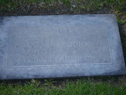
| Birth | : | 27 Jul 1859 St. Lawrence County, New York, USA |
| Death | : | 22 May 1924 Sioux Falls, Minnehaha County, South Dakota, USA |
| Burial | : | Mulberry Cemetery, England, Lonoke County, USA |
| Coordinate | : | 34.5219002, -91.9669037 |
| Description | : | Parents: William John 1833 – 1911 Mary Jane Meyers 1839 – 19111920 United States Federal Census about Catherine Sweet Name: Catherine Sweet Home in 1920: Sioux Falls Ward 8, Minnehaha, South Dakota Age: 60 Estimated Birth Year: abt 1860 Birthplace: New York Relation to Head of House: Wife Spouse's Name: Jene W Sweet Father's Birth Place: Canada Mother's Birth Place: Canada Marital Status: Married Race: White Sex: Female Able to read: Yes Able to Write: Yes Neighbors: View others on page Household Members: Name Age Jene W Sweet 72 Catherine Sweet 60 |
frequently asked questions (FAQ):
-
Where is Catherine Anne “Annie” Alguire Sweet's memorial?
Catherine Anne “Annie” Alguire Sweet's memorial is located at: Mulberry Cemetery, England, Lonoke County, USA.
-
When did Catherine Anne “Annie” Alguire Sweet death?
Catherine Anne “Annie” Alguire Sweet death on 22 May 1924 in Sioux Falls, Minnehaha County, South Dakota, USA
-
Where are the coordinates of the Catherine Anne “Annie” Alguire Sweet's memorial?
Latitude: 34.5219002
Longitude: -91.9669037
Family Members:
Parent
Spouse
Siblings
Children
Flowers:
Nearby Cemetories:
1. Mulberry Cemetery
England, Lonoke County, USA
Coordinate: 34.5219002, -91.9669037
2. Nellum Cemetery
England, Lonoke County, USA
Coordinate: 34.5093994, -91.9627991
3. Nelson Cemetery
England, Lonoke County, USA
Coordinate: 34.5084297, -91.9640508
4. Faver Cemetery
Lonoke County, USA
Coordinate: 34.4892006, -91.9914017
5. Clear Lake Cemetery
England, Lonoke County, USA
Coordinate: 34.5410910, -92.0192760
6. Jones Cemetery
Pine Bluff, Jefferson County, USA
Coordinate: 34.4771996, -91.9972000
7. Allison-Walton-Venable-Wilder Cemetery
Hill Township, Pulaski County, USA
Coordinate: 34.5112050, -92.0422520
8. Tomberlin Cemetery
England, Lonoke County, USA
Coordinate: 34.5217018, -91.8752975
9. Morris Baptist Church Cemetery
Keo, Lonoke County, USA
Coordinate: 34.5845700, -92.0188020
10. Chapel Hill Cemetery
Coy, Lonoke County, USA
Coordinate: 34.5449330, -91.8772620
11. Johnson Cemetery
Lonoke County, USA
Coordinate: 34.5447127, -91.8764227
12. Keo Cemetery
Keo, Lonoke County, USA
Coordinate: 34.5988998, -92.0006027
13. Union Valley Cemetery
Coy, Lonoke County, USA
Coordinate: 34.5638700, -91.8813800
14. Central Baptist Cemetery
Dudley Lake Township, Jefferson County, USA
Coordinate: 34.4683900, -91.8840700
15. Mount Pleasant Cemetery
Jefferson County, USA
Coordinate: 34.4439011, -91.9203033
16. Lonoke County Rural Burial Ground
Keo, Lonoke County, USA
Coordinate: 34.5993000, -92.0403000
17. Fields Cemetery
Jefferson County, USA
Coordinate: 34.4225006, -91.9744034
18. New Hope Church and Cemetery
Sherrill, Jefferson County, USA
Coordinate: 34.4053810, -91.9762460
19. Jerusalem Church Cemetery
Altheimer, Jefferson County, USA
Coordinate: 34.4485610, -91.8399160
20. Antioch Cemetery
Sherrill, Jefferson County, USA
Coordinate: 34.3936005, -91.9835968
21. Coleman Chapel Cemetery
Jefferson County, USA
Coordinate: 34.4171810, -91.8717260
22. Hickory Grove Cemetery
Lonoke County, USA
Coordinate: 34.6431007, -92.0280991
23. Davis Cemetery
Sherrill, Jefferson County, USA
Coordinate: 34.3881700, -91.9666700
24. Gethsemane Cemetery
Gethsemane, Jefferson County, USA
Coordinate: 34.4158780, -91.8675290


