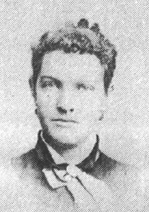
| Birth | : | 16 Jun 1820 Detroit, Somerset County, Maine, USA |
| Death | : | 24 Aug 1913 Arbuckle, Colusa County, California, USA |
| Burial | : | San Joaquin Cemetery, Sacramento, Sacramento County, USA |
| Coordinate | : | 38.4387665, -121.4034653 |
| Description | : | Daughter of John Blaine Kennedy and Mary Trott. Born in Maine but by 1836, the family had returned to the parents' roots in New Brunswick, Canada. Eventually, the family relocated to Detroit, Michigan. It was here on July 12, 1840, that she married Henry "Harry" James Jackson. Around 1844 the Jacksons, along with most of the Kennedy clan, moved to Jackson County, Iowa. Harry owned a grist mill, saw mill, and a farm there. In 1861 the family made the six-month wagon train trek to California. Harry and Kittie settled in San Joaquin Township, Sacramento County. They were among the... Read More |
frequently asked questions (FAQ):
-
Where is Catherine Augusta “Kittie” Kennedy Jackson's memorial?
Catherine Augusta “Kittie” Kennedy Jackson's memorial is located at: San Joaquin Cemetery, Sacramento, Sacramento County, USA.
-
When did Catherine Augusta “Kittie” Kennedy Jackson death?
Catherine Augusta “Kittie” Kennedy Jackson death on 24 Aug 1913 in Arbuckle, Colusa County, California, USA
-
Where are the coordinates of the Catherine Augusta “Kittie” Kennedy Jackson's memorial?
Latitude: 38.4387665
Longitude: -121.4034653
Family Members:
Spouse
Children
Flowers:
Nearby Cemetories:
1. San Joaquin Cemetery
Sacramento, Sacramento County, USA
Coordinate: 38.4387665, -121.4034653
2. East Lawn Elk Grove Memorial Park
Elk Grove, Sacramento County, USA
Coordinate: 38.4282608, -121.3969955
3. Elk Grove Cosumnes-Cemetery
Elk Grove, Sacramento County, USA
Coordinate: 38.4088593, -121.3875504
4. Hilltop Cemetery
Elk Grove, Sacramento County, USA
Coordinate: 38.4156490, -121.3534950
5. Chua Phuoc Thien Temple Columbarium
Sacramento, Sacramento County, USA
Coordinate: 38.4555400, -121.3345500
6. Sacramento Pet Cemetery
Sacramento, Sacramento County, USA
Coordinate: 38.4815870, -121.3402080
7. Elder Creek Cemetery
Florin, Sacramento County, USA
Coordinate: 38.5111008, -121.4169006
8. Pleasant Grove Cemetery
Elk Grove, Sacramento County, USA
Coordinate: 38.4302220, -121.3107670
9. Franklin Cemetery
Franklin, Sacramento County, USA
Coordinate: 38.3761749, -121.4558029
10. Home of Peace Cemetery
Sacramento, Sacramento County, USA
Coordinate: 38.5137558, -121.4382782
11. Sacramento Memorial Lawn Cemetery
Sacramento, Sacramento County, USA
Coordinate: 38.5146484, -121.4380341
12. Tinh Xa Ngoc An Temple Columbarium
Sacramento, Sacramento County, USA
Coordinate: 38.5190200, -121.4159500
13. Sacramento County Veterans Memorial Cemetery
Sacramento, Sacramento County, USA
Coordinate: 38.5252838, -121.4239120
14. Sacramento County Cemetery
Sacramento County, USA
Coordinate: 38.5267900, -121.4233700
15. Russian Orthodox Cemetery
Sacramento, Sacramento County, USA
Coordinate: 38.5268800, -121.4244300
16. Sacramento County Hospital Cemetery
Sacramento, Sacramento County, USA
Coordinate: 38.5289300, -121.4239100
17. Saint Mary's Catholic Cemetery and Mausoleum
Sacramento, Sacramento County, USA
Coordinate: 38.5298900, -121.4261200
18. Quiet Haven Memorial Park Cemetery
Sacramento, Sacramento County, USA
Coordinate: 38.5109711, -121.3245621
19. Saint Rose Cemetery (Defunct)
Sacramento, Sacramento County, USA
Coordinate: 38.5208015, -121.4672012
20. Bellview Cemetery
Sacramento, Sacramento County, USA
Coordinate: 38.5153580, -121.3257446
21. Union Cemetery
Sacramento County, USA
Coordinate: 38.4477997, -121.2619019
22. Pho Minh Temple Columbarium
Sacramento, Sacramento County, USA
Coordinate: 38.5340100, -121.4769000
23. Camellia Memorial Lawn Cemetery
Sacramento, Sacramento County, USA
Coordinate: 38.5242004, -121.3097000
24. Point Pleasant Cemetery
Point Pleasant, Sacramento County, USA
Coordinate: 38.3308525, -121.4638290


