
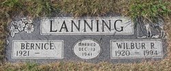
Catherine Bernice Bartlett Lanning
| Birth | : | 14 Dec 1921 Great Falls, Cascade County, Montana, USA |
| Death | : | 22 Jun 2009 Big Sandy, Chouteau County, Montana, USA |
| Burial | : | Dun Dá Radharc Kilnamartyra, Ireland |
| Coordinate | : | 51.8908470, -9.0190910 |
| Description | : | Catherine Bernice (Bartlett) Lanning, 87, died June 22, in the Big Sandy Medical Center, after a long battle with cancer. Funeral services at United Methodist Church in Big Sandy. Burial in Big Sandy Cemetery. Bernice was born Dec. 14, 1921, to Thomas and Sophia (Stenseth) Bartlett in Great Falls. She grew up in Great Falls and graduated from Great Falls High in 1939 and from the College of Great Falls in 1941. Bernice taught school south of Big Sandy where she met Wilbur Lanning. They were married Dec. 13, 1941, and lived on their ranch south of Big Sandy on... Read More |
frequently asked questions (FAQ):
-
Where is Catherine Bernice Bartlett Lanning's memorial?
Catherine Bernice Bartlett Lanning's memorial is located at: Dun Dá Radharc Kilnamartyra, Ireland.
-
When did Catherine Bernice Bartlett Lanning death?
Catherine Bernice Bartlett Lanning death on 22 Jun 2009 in Big Sandy, Chouteau County, Montana, USA
-
Where are the coordinates of the Catherine Bernice Bartlett Lanning's memorial?
Latitude: 51.8908470
Longitude: -9.0190910
Family Members:
Spouse

Flowers:


Nearby Cemetories:
1. Dun Dá Radharc Kilnamartyra
Ireland
Coordinate: 51.8908470, -9.0190910
2. Dromtariffe Old Cemetery
Ireland
Coordinate: 52.1240500, -8.9560800
3. Caheragh Old Burial Ground
Ireland
Coordinate: 51.6326660, -9.2943333
4. Caheragh New Cemetery
Ireland
Coordinate: 51.6317106, -9.3091787
5. Cullen Church of Ireland Cemetery
Ireland
Coordinate: 51.7696500, -8.4795200
6. Kilnanima Cemetery
Ireland
Coordinate: 52.2166670, -9.3833330
7. Castlehyde Church of Ireland Churchyard
Ireland
Coordinate: 52.1416530, -8.3145460
8. Aghada Old Cemetery
Ireland
Coordinate: 51.8365610, -8.2109196
9. Duagh Cemetery
Ireland
Coordinate: 52.4195325, -9.3803950
10. Churchill Burial Ground
Ireland
Coordinate: 52.2906277, -9.8233326
11. Dromod Burial Ground Old Section
Ireland
Coordinate: 51.8663790, -10.1307410
12. Kinard Burial Grounds
Ireland
Coordinate: 52.1263990, -10.1971550
13. Knockerra Graveyard
Ireland
Coordinate: 52.6551060, -9.3978000
14. Kilnagalliagh Burial Ground
Ireland
Coordinate: 52.6481000, -9.5672000
15. Punchbowl Church Cemetery
Ireland
Coordinate: 52.6953216, -8.6843746
16. Kilcrony (Kilcrona) Graveyard
Ireland
Coordinate: 52.6150580, -9.6907070
17. Moyarta Graveyard
Ireland
Coordinate: 52.6134100, -9.7132120
18. Ballycannon Cemetery
Ireland
Coordinate: 52.7066100, -8.6472180
19. RuheWald Ribbesbüttel
Ribbesbuttel, Landkreis Gifhorn, Germany
Coordinate: 52.2528000, -10.3044000
20. Kildeema Burial Ground
Ireland
Coordinate: 52.6979100, -9.5897800
21. Kilcross Cemetery
Ireland
Coordinate: 52.8813300, -9.0409500
22. Churchtown Graveyard
Ireland
Coordinate: 52.3544300, -7.5091600
23. Clouna Cemetery
Ireland
Coordinate: 52.9369940, -9.2013590
24. Saint Nicholas Roman Catholic Church
Ireland
Coordinate: 52.7019670, -7.3446970