


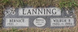
Wilbur Robert Lanning
| Birth | : | 12 May 1920 Big Sandy, Chouteau County, Montana, USA |
| Death | : | 10 Aug 1994 Big Sandy, Chouteau County, Montana, USA |
| Burial | : | Masbrough Cemetery, Rotherham, Metropolitan Borough of Rotherham, England |
| Coordinate | : | 53.4326800, -1.3873600 |
| Description | : | Obit from Find A Grave contributor "Cara": The Mountaineer, Big Sandy, MT, 17 Aug 1994 (excerpt) Wilbur Robert Lanning was born on his dad's homestead, May 12, 1920. He died at his home on Aug. 10, 1994. His parents, Louis and Alma, moved to Great Falls for eight years but returned to Big Sandy to take on the Jappe ranch. Wilbur took over the responsibility of the ranch at an early age because of his father's illness. He married Bernice Bartlett, the school teacher from up the road, on Dec. 13, 1941. He enjoyed work on the ranch... Read More |
frequently asked questions (FAQ):
-
Where is Wilbur Robert Lanning's memorial?
Wilbur Robert Lanning's memorial is located at: Masbrough Cemetery, Rotherham, Metropolitan Borough of Rotherham, England.
-
When did Wilbur Robert Lanning death?
Wilbur Robert Lanning death on 10 Aug 1994 in Big Sandy, Chouteau County, Montana, USA
-
Where are the coordinates of the Wilbur Robert Lanning's memorial?
Latitude: 53.4326800
Longitude: -1.3873600
Family Members:
Parent
Spouse
Siblings
Flowers:


Nearby Cemetories:
1. Masbrough Cemetery
Rotherham, Metropolitan Borough of Rotherham, England
Coordinate: 53.4326800, -1.3873600
2. St. Thomas the Apostle Churchyard
Kimberworth, Metropolitan Borough of Rotherham, England
Coordinate: 53.4337400, -1.3936000
3. St Paul, Masbrough
Rotherham, Metropolitan Borough of Rotherham, England
Coordinate: 53.4311840, -1.3768820
4. Masbrough Common Cemetery
Rotherham, Metropolitan Borough of Rotherham, England
Coordinate: 53.4321800, -1.3721670
5. St. Bede Roman Catholic Churchyard
Rotherham, Metropolitan Borough of Rotherham, England
Coordinate: 53.4301730, -1.3681120
6. Masborough Congregational Chapel
Rotherham, Metropolitan Borough of Rotherham, England
Coordinate: 53.4313350, -1.3656320
7. All Saints Churchyard
Rotherham, Metropolitan Borough of Rotherham, England
Coordinate: 53.4309470, -1.3568280
8. St. Thomas' Churchyard
Rotherham, Metropolitan Borough of Rotherham, England
Coordinate: 53.4303087, -1.3569402
9. St. Lawrence Churchyard
Rotherham, Metropolitan Borough of Rotherham, England
Coordinate: 53.4111526, -1.3928234
10. Saint Lawrence Churchyard
Metropolitan Borough of Sheffield, England
Coordinate: 53.4110227, -1.3934800
11. Greasbrough Cemetery
Rawmarsh, Metropolitan Borough of Rotherham, England
Coordinate: 53.4561300, -1.3849900
12. Moorgate Cemetery
Rotherham, Metropolitan Borough of Rotherham, England
Coordinate: 53.4201742, -1.3537699
13. St Mary
Greasbrough, Metropolitan Borough of Rotherham, England
Coordinate: 53.4562120, -1.3717680
14. St. George's Churchyard
Brinsworth, Metropolitan Borough of Rotherham, England
Coordinate: 53.4077700, -1.3677700
15. Shiregreen Cemetery
Sheffield, Metropolitan Borough of Sheffield, England
Coordinate: 53.4212050, -1.4360650
16. Rotherham Cholera Burial Ground
Rotherham, Metropolitan Borough of Rotherham, England
Coordinate: 53.4343420, -1.3313390
17. Rawmarsh War Memorial
Rawmarsh, Metropolitan Borough of Rotherham, England
Coordinate: 53.4576880, -1.3450730
18. High Street Cemetery
Rawmarsh, Metropolitan Borough of Rotherham, England
Coordinate: 53.4587900, -1.3448100
19. St. Thomas' Churchyard
Brightside, Metropolitan Borough of Sheffield, England
Coordinate: 53.4068100, -1.4327000
20. Holy Trinity Churchyard
Thorpe Hesley, Metropolitan Borough of Rotherham, England
Coordinate: 53.4595020, -1.4317560
21. Holy Trinity Churchyard Extension
Thorpe Hesley, Metropolitan Borough of Rotherham, England
Coordinate: 53.4603190, -1.4314840
22. Greasbrough Lane Cemetery
Rawmarsh, Metropolitan Borough of Rotherham, England
Coordinate: 53.4620370, -1.3462330
23. Attercliffe Hilltop Cemetery
Attercliffe, Metropolitan Borough of Sheffield, England
Coordinate: 53.3992340, -1.4264000
24. Tinsley Park Cemetery
Sheffield, Metropolitan Borough of Sheffield, England
Coordinate: 53.3932810, -1.4077840