
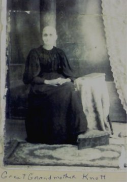

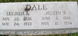
Catherine Dale Knott
| Birth | : | 9 Sep 1827 Union County, Pennsylvania, USA |
| Death | : | 12 Apr 1902 Central City, Merrick County, Nebraska, USA |
| Burial | : | Forestville Cemetery, Maplewood, Door County, USA |
| Coordinate | : | 44.7477780, -87.4713890 |
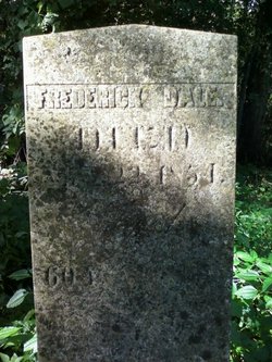
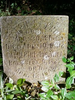
| Description | : | Tipton Advertiser 15 April 1902 pg 8 Catherine Dale was born in Union county, Pa., on September 9th, 1827 and died at the residence of her son, Fred Knott in Central City, Nebraska, on April 11th, 1902, aged 74 years and 7 months. She was married to Joseph Scull Knott, Sept. 17th, 1849. To them were given eleven children, six sons and five daughters all of whom are still living. Mr. Knott having died on April 10th, 1893, she continued her life's work alone, which at times was filled with hardships, but sustained by her faith in Jesus... Read More |
frequently asked questions (FAQ):
-
Where is Catherine Dale Knott's memorial?
Catherine Dale Knott's memorial is located at: Forestville Cemetery, Maplewood, Door County, USA.
-
When did Catherine Dale Knott death?
Catherine Dale Knott death on 12 Apr 1902 in Central City, Merrick County, Nebraska, USA
-
Where are the coordinates of the Catherine Dale Knott's memorial?
Latitude: 44.7477780
Longitude: -87.4713890
Family Members:
Parent
Spouse
Siblings

Children
Flowers:


Nearby Cemetories:
1. Forestville Cemetery
Maplewood, Door County, USA
Coordinate: 44.7477780, -87.4713890
2. Saint Marys Cemetery
Maplewood, Door County, USA
Coordinate: 44.7475000, -87.4705560
3. Saint Mary's Cemetery
Forestville, Door County, USA
Coordinate: 44.7164001, -87.4772034
4. Geise Cemetery
Maplewood, Door County, USA
Coordinate: 44.7694016, -87.5318985
5. Tornado Memorial Park
Brussels, Door County, USA
Coordinate: 44.7658030, -87.5405740
6. Forest Lutheran Cemetery
Carnot, Door County, USA
Coordinate: 44.7049690, -87.4186160
7. Emmanuel Lutheran Cemetery
Brussels, Door County, USA
Coordinate: 44.7192300, -87.5472000
8. Saint Peters Lutheran Cemetery
Forestville, Door County, USA
Coordinate: 44.6868600, -87.4799500
9. Emmanuel Lutheran Cemetery
Forestville, Door County, USA
Coordinate: 44.6906013, -87.5049973
10. Tanum Evangelical Lutheran Cemetery
Vignes, Door County, USA
Coordinate: 44.7265670, -87.3775940
11. Brockhausen Cemetery
Forestville, Door County, USA
Coordinate: 44.6749992, -87.4642029
12. Mount Olive Cemetery
Sturgeon Bay, Door County, USA
Coordinate: 44.7805500, -87.3764600
13. Salem Lutheran Cemetery
Nasewaupee, Door County, USA
Coordinate: 44.8273600, -87.4794500
14. Elton Schulties Memorial Cemetery
Nasewaupee, Door County, USA
Coordinate: 44.8278008, -87.4792023
15. Schumacher Cemetery
Sturgeon Bay, Door County, USA
Coordinate: 44.8205986, -87.4235001
16. Shiloh Moravian Church Cemetery
Sturgeon Bay, Door County, USA
Coordinate: 44.7900000, -87.3716300
17. Qualman Family Burial Ground
Algoma, Kewaunee County, USA
Coordinate: 44.6627800, -87.4708900
18. Pilgrims Rest Cemetery
Sturgeon Bay, Door County, USA
Coordinate: 44.8333520, -87.4800970
19. Clay Banks Cemetery
Vignes, Door County, USA
Coordinate: 44.7078018, -87.3555984
20. Saint Francis Church Cemetery
Brussels, Door County, USA
Coordinate: 44.7497890, -87.6044370
21. South Side Cemetery
Sturgeon Bay, Door County, USA
Coordinate: 44.8168500, -87.3721600
22. Saint Michaels Cemetery
Rosiere, Door County, USA
Coordinate: 44.6982994, -87.5986023
23. Saint Josephs Catholic Cemetery
Brussels, Door County, USA
Coordinate: 44.8101300, -87.6010700
24. White Star Cemetery
Brussels, Door County, USA
Coordinate: 44.7701870, -87.6254570