

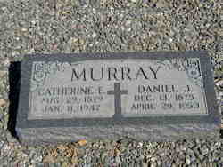
Catherine E. Dolan Murray
| Birth | : | 29 Aug 1879 Livermore, Alameda County, California, USA |
| Death | : | 11 Jan 1947 Oakland, Alameda County, California, USA |
| Burial | : | Los Banos Cemetery, Los Banos, Merced County, USA |
| Coordinate | : | 37.0470200, -120.8547000 |
| Plot | : | Row 11 East |
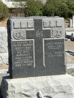
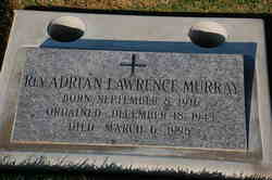
| Description | : | Catherine E. Murray Died in Oakland, California Wife of Daniel J. Murray Mother of James V. and Daniel J. Murray, Mrs. H.V. Armstead, William F. McFarland, Rev. Adrian L. Murray and Mrs. Creed D. Riser Grandmother of 14 grandchildren A native of Livermore, California, age 67 years Funeral from the Fruitvale Chapel of the Clarence N. Cooper Mortuary, Oakland Solemn Requiem Mass will be sung at St. Louis Bertram's Church; rosary in the evening Interment, St. Michael's Cemetery, Livermore San Francisco Examiner, Sunday, January 12, 1947, page 25 |
frequently asked questions (FAQ):
-
Where is Catherine E. Dolan Murray's memorial?
Catherine E. Dolan Murray's memorial is located at: Los Banos Cemetery, Los Banos, Merced County, USA.
-
When did Catherine E. Dolan Murray death?
Catherine E. Dolan Murray death on 11 Jan 1947 in Oakland, Alameda County, California, USA
-
Where are the coordinates of the Catherine E. Dolan Murray's memorial?
Latitude: 37.0470200
Longitude: -120.8547000
Family Members:
Spouse
Children
Flowers:


Nearby Cemetories:
1. Calvary Cemetery
Los Banos, Merced County, USA
Coordinate: 37.0486800, -120.8547000
2. Dos Palos Cemetery
Dos Palos, Merced County, USA
Coordinate: 36.9831009, -120.6357651
3. San Joaquin Valley National Cemetery
Santa Nella, Merced County, USA
Coordinate: 37.1198170, -121.0738000
4. Cottonwood Cemetery
Gustine, Merced County, USA
Coordinate: 37.1878128, -121.0403900
5. Harper Family Cemetery
Los Banos, Merced County, USA
Coordinate: 37.0215379, -121.1236853
6. Stevinson Sunnyside Cemetery
Stevinson, Merced County, USA
Coordinate: 37.3292007, -120.9231033
7. Colonel James J Stevinson Cemetery
Stevinson, Merced County, USA
Coordinate: 37.3572044, -120.9112320
8. Hills Ferry Cemetery
Newman, Stanislaus County, USA
Coordinate: 37.3321991, -121.0496979
9. South Hilmar Cemetery
Hilmar, Merced County, USA
Coordinate: 37.3802681, -120.8868408
10. North Hilmar Cemetery
Hilmar, Merced County, USA
Coordinate: 37.4146614, -120.8864288
11. Franklin Pet Cemetery
Merced, Merced County, USA
Coordinate: 37.3228970, -120.5425370
12. Calvary Cemetery
Merced, Merced County, USA
Coordinate: 37.2868996, -120.4860992
13. Winton Cemetery
Winton, Merced County, USA
Coordinate: 37.3820267, -120.6260223
14. Evergreen Memorial Park
Merced, Merced County, USA
Coordinate: 37.2907982, -120.4689026
15. Merced Cemetery
Merced, Merced County, USA
Coordinate: 37.2925835, -120.4701004
16. Cherry Hill Cemetery
Panoche, San Benito County, USA
Coordinate: 36.6150017, -120.9586029
17. Turlock Memorial Park
Turlock, Stanislaus County, USA
Coordinate: 37.4937592, -120.8659821
18. Fancher Memorial
Tuttle, Merced County, USA
Coordinate: 37.2949400, -120.3778300
19. Saint Francis Episcopal Church Columbarium
Turlock, Stanislaus County, USA
Coordinate: 37.5014300, -120.8368400
20. Chowchilla Cemetery
Chowchilla, Madera County, USA
Coordinate: 37.0880318, -120.2834854
21. Plainsburg Cemetery
Plainsburg, Merced County, USA
Coordinate: 37.2350960, -120.3303757
22. Paicines Cemetery
Paicines, San Benito County, USA
Coordinate: 36.7088580, -121.2456330
23. Saint Benedicts Columbarium
Hollister, San Benito County, USA
Coordinate: 36.8337440, -121.3667120
24. Calvary-Sacred Heart Cemetery
Hollister, San Benito County, USA
Coordinate: 36.8483009, -121.3767014