
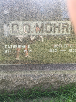
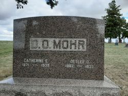
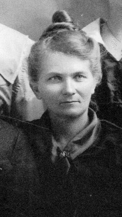
Catherine E Harksen Mohr
| Birth | : | 10 Dec 1871 Boone, Boone County, Iowa, USA |
| Death | : | 23 Mar 1935 Terril, Dickinson County, Iowa, USA |
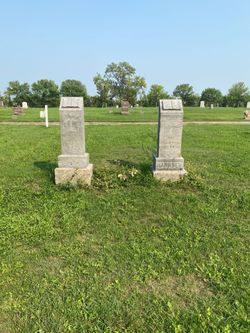
| Burial | : | Fairview Cemetery, Terril, Dickinson County, USA |
| Coordinate | : | 43.2977982, -94.9349976 |
| Plot | : | 171-1 |
| Description | : | Obituary is published in the Spirit Lake Beacon, March 28, 1935. ----------- |
frequently asked questions (FAQ):
-
Where is Catherine E Harksen Mohr's memorial?
Catherine E Harksen Mohr's memorial is located at: Fairview Cemetery, Terril, Dickinson County, USA.
-
When did Catherine E Harksen Mohr death?
Catherine E Harksen Mohr death on 23 Mar 1935 in Terril, Dickinson County, Iowa, USA
-
Where are the coordinates of the Catherine E Harksen Mohr's memorial?
Latitude: 43.2977982
Longitude: -94.9349976
Family Members:
Parent

Spouse
Siblings
Children

Flowers:


Nearby Cemetories:
1. Fairview Cemetery
Terril, Dickinson County, USA
Coordinate: 43.2977982, -94.9349976
2. Richland Township Cemetery
Terril, Dickinson County, USA
Coordinate: 43.3565323, -94.9927821
3. Saint Patricks Cemetery
Estherville, Emmet County, USA
Coordinate: 43.3843994, -94.8283005
4. Oak Hill Cemetery
Estherville, Emmet County, USA
Coordinate: 43.3986015, -94.8518982
5. Wallingford Lutheran Cemetery
Wallingford, Emmet County, USA
Coordinate: 43.3128014, -94.7731018
6. Lost Island Lutheran Cemetery
Lost Island Township, Palo Alto County, USA
Coordinate: 43.1980000, -94.8375000
7. Graettinger City Cemetery
Graettinger, Palo Alto County, USA
Coordinate: 43.2550011, -94.7722015
8. Saint Jacobs Cemetery
Graettinger, Palo Alto County, USA
Coordinate: 43.2546997, -94.7705994
9. East Side Cemetery
Estherville, Emmet County, USA
Coordinate: 43.4068985, -94.8264008
10. Superior Township Cemetery
Superior, Dickinson County, USA
Coordinate: 43.4399986, -94.9533005
11. Fairview Cemetery
Clay County, USA
Coordinate: 43.1899986, -95.0800018
12. East Side Memorial Cemetery
Estherville, Emmet County, USA
Coordinate: 43.4267750, -94.8265600
13. Norwegian Cemetery
Estherville, Emmet County, USA
Coordinate: 43.4291992, -94.8261032
14. Estherville Lutheran Cemetery
Estherville, Emmet County, USA
Coordinate: 43.4298000, -94.8263000
15. Saint Paul Lutheran Cemetery
Walnut Township, Palo Alto County, USA
Coordinate: 43.1866740, -94.7872050
16. Bedell Gravesite
Spirit Lake, Dickinson County, USA
Coordinate: 43.4128430, -95.0773690
17. Milford Cemetery
Milford, Dickinson County, USA
Coordinate: 43.3092003, -95.1481018
18. Okoboji Cemetery
Arnolds Park, Dickinson County, USA
Coordinate: 43.3649406, -95.1303558
19. Highland Cemetery
Highland Township, Palo Alto County, USA
Coordinate: 43.1497002, -94.8578033
20. Lakeview Gardens Cemetery
Spirit Lake, Dickinson County, USA
Coordinate: 43.3925000, -95.1119000
21. Rose Hill Cemetery (Defunct)
Spirit Lake, Dickinson County, USA
Coordinate: 43.4077600, -95.0976130
22. Pioneer Cemetery
Arnolds Park, Dickinson County, USA
Coordinate: 43.3655000, -95.1403000
23. Gardner Family Cemetery
Arnolds Park, Dickinson County, USA
Coordinate: 43.3654410, -95.1403480
24. Valley View Cemetery
Walnut Township, Palo Alto County, USA
Coordinate: 43.2428000, -94.7212000