
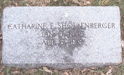
Catherine Elizabeth “Kate” Brobst Shollenberger
| Birth | : | 5 Jan 1845 Berks County, Pennsylvania, USA |
| Death | : | 6 Apr 1918 Denver, Denver County, Colorado, USA |
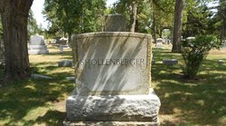
| Burial | : | Carroll City Cemetery, Carroll, Carroll County, USA |
| Coordinate | : | 42.0560963, -94.8599856 |
| Description | : | Catherine was the daughter of Daniel Perry Brobst & Maria Anna Brobst. She married John Schollenberger on 28 MAY 1864 in Lynntown, Lehigh, Pennsylvania. They were the parents of Benjamin, John, Daniel, Mary (Gillelan), Grace, George, Ida, and Robert. April 10, 1918 - Carroll Herald - John A Shollenberger recieved word Saturday of the death of his mother in Denver. Her remains were shipped to Carroll, arriving yesterday and laid away in the Carroll cemetery. Mrs Shollenberger last fall came to Iowa and visited with her sons at Carroll and Marshalltown for serveral weeks, saw her old neighbors and... Read More |
frequently asked questions (FAQ):
-
Where is Catherine Elizabeth “Kate” Brobst Shollenberger's memorial?
Catherine Elizabeth “Kate” Brobst Shollenberger's memorial is located at: Carroll City Cemetery, Carroll, Carroll County, USA.
-
When did Catherine Elizabeth “Kate” Brobst Shollenberger death?
Catherine Elizabeth “Kate” Brobst Shollenberger death on 6 Apr 1918 in Denver, Denver County, Colorado, USA
-
Where are the coordinates of the Catherine Elizabeth “Kate” Brobst Shollenberger's memorial?
Latitude: 42.0560963
Longitude: -94.8599856
Family Members:
Spouse
Children
Flowers:


Nearby Cemetories:
1. Carroll City Cemetery
Carroll, Carroll County, USA
Coordinate: 42.0560963, -94.8599856
2. Mount Olivet Cemetery
Carroll, Carroll County, USA
Coordinate: 42.0536340, -94.8595510
3. Holy Angels Cemetery
Carroll County, USA
Coordinate: 42.0014000, -94.9141998
4. Saint Francis Cemetery
Maple River, Carroll County, USA
Coordinate: 42.0969009, -94.9372025
5. Saint Marys Catholic Cemetery
Willey, Carroll County, USA
Coordinate: 41.9783363, -94.8212204
6. Holy Family Cemetery
Lidderdale, Carroll County, USA
Coordinate: 42.1178017, -94.7839966
7. West Lawn Cemetery
Glidden, Carroll County, USA
Coordinate: 42.0649986, -94.7406006
8. Immanuel Cemetery
Lidderdale, Carroll County, USA
Coordinate: 42.1389008, -94.8022003
9. Saint Augustine Cemetery
Halbur, Carroll County, USA
Coordinate: 42.0066986, -94.9744034
10. Our Lady Of Mount Carmel Cemetery
Mount Carmel, Carroll County, USA
Coordinate: 42.1547012, -94.9088974
11. Arcadia Cemetery
Arcadia Township, Carroll County, USA
Coordinate: 42.1000680, -95.0130550
12. East Liberty Cemetery
Lidderdale, Carroll County, USA
Coordinate: 42.1591988, -94.7636032
13. Saint Johns Catholic Cemetery
Arcadia, Carroll County, USA
Coordinate: 42.0855406, -95.0341577
14. Dickson Cemetery
Glidden Township, Carroll County, USA
Coordinate: 42.1074982, -94.6939011
15. McCurdy Cemetery
Carroll County, USA
Coordinate: 41.9403000, -94.7649994
16. Saint Bernards Cemetery
Breda, Carroll County, USA
Coordinate: 42.1786003, -94.9732971
17. Elba Cemetery
Templeton, Carroll County, USA
Coordinate: 41.9068985, -94.9131012
18. Sacred Heart Cemetery
Templeton, Carroll County, USA
Coordinate: 41.9138746, -94.9460994
19. North Coon Cemetery
Carroll County, USA
Coordinate: 42.1260986, -94.6716995
20. Dedham Cemetery
Dedham, Carroll County, USA
Coordinate: 41.8993988, -94.8225021
21. Saint Josephs Cemetery
Dedham, Carroll County, USA
Coordinate: 41.8993988, -94.8210983
22. Old Carrollton Cemetery
Carrollton, Carroll County, USA
Coordinate: 41.9233017, -94.7403030
23. Lanesboro Cemetery
Lanesboro, Carroll County, USA
Coordinate: 42.1810989, -94.7230988
24. Luckow Cemetery
Auburn, Sac County, USA
Coordinate: 42.2168999, -94.9266968