


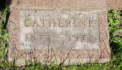
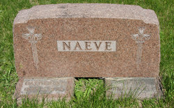
Catherine Friedrichsen Naeve
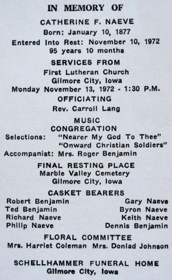
| Birth | : | 10 Jan 1877 Boone County, Iowa, USA |
| Death | : | 10 Nov 1972 Pocahontas, Pocahontas County, Iowa, USA |
| Burial | : | Marble Valley Cemetery, Gilmore City, Humboldt County, USA |
| Coordinate | : | 42.7458850, -94.4430150 |
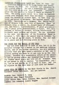
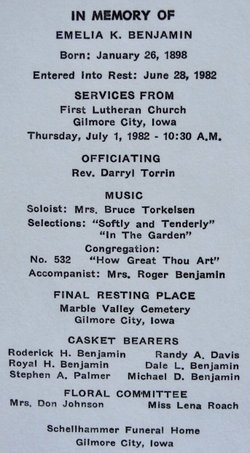
| Description | : | Catherine Friedrichsen Naeve was born to Hans and Catherine Friedrichsen in Boone County near Bouton on Jan. 10, 1877. She received her education in the country school. She was a seamstress and continued this work along with her housewife activities after she was married to Peter F. Naeve on Feb. 3, 1897. The young couple moved to a farm in Humboldt county near Bradgate where they and their neighbors faced the hazards of pioneer days. In 1929 they retired and moved to Bradgate. Her husband passed away in 1939. Surviving are a daughter, Mrs. Emelia Benjamin of Gilmore City; sons... Read More |
frequently asked questions (FAQ):
-
Where is Catherine Friedrichsen Naeve's memorial?
Catherine Friedrichsen Naeve's memorial is located at: Marble Valley Cemetery, Gilmore City, Humboldt County, USA.
-
When did Catherine Friedrichsen Naeve death?
Catherine Friedrichsen Naeve death on 10 Nov 1972 in Pocahontas, Pocahontas County, Iowa, USA
-
Where are the coordinates of the Catherine Friedrichsen Naeve's memorial?
Latitude: 42.7458850
Longitude: -94.4430150
Family Members:
Parent

Spouse
Siblings
Children
Flowers:


Nearby Cemetories:
1. Marble Valley Cemetery
Gilmore City, Humboldt County, USA
Coordinate: 42.7458850, -94.4430150
2. Saint Johns Catholic Cemetery
Gilmore City, Pocahontas County, USA
Coordinate: 42.7332993, -94.4672012
3. Mount Hope Cemetery
Unique, Humboldt County, USA
Coordinate: 42.7169250, -94.3740570
4. Clinton-Garfield Cemetery
Rolfe, Pocahontas County, USA
Coordinate: 42.8055300, -94.5202500
5. Saint Margarets Cemetery
Rolfe, Pocahontas County, USA
Coordinate: 42.8164978, -94.5307465
6. Old Rolfe Cemetery
Rolfe, Pocahontas County, USA
Coordinate: 42.8403511, -94.4764175
7. McKnight Cemetery
Bode, Humboldt County, USA
Coordinate: 42.8635100, -94.4055600
8. Omer-Thorsen Farm Cemetery
Ottosen, Humboldt County, USA
Coordinate: 42.8735742, -94.4085743
9. Rutland Township Cemetery
Rutland, Humboldt County, USA
Coordinate: 42.7574997, -94.2652969
10. Saint Johns Lutheran Cemetery
Palmer, Pocahontas County, USA
Coordinate: 42.6268997, -94.5205994
11. Our Saviors Cemetery
Humboldt County, USA
Coordinate: 42.6596985, -94.2956009
12. Powhatan Cemetery
Plover, Pocahontas County, USA
Coordinate: 42.8557396, -94.5801773
13. Union Cemetery
Ottosen, Humboldt County, USA
Coordinate: 42.8879128, -94.3792496
14. Union Cemetery
Humboldt, Humboldt County, USA
Coordinate: 42.7407990, -94.2375031
15. Saint Patricks Cemetery
Clare, Webster County, USA
Coordinate: 42.5943985, -94.4419022
16. Calvary Cemetery
Pocahontas, Pocahontas County, USA
Coordinate: 42.7335000, -94.6597000
17. Summit Hill Cemetery
Pocahontas, Pocahontas County, USA
Coordinate: 42.7315000, -94.6595000
18. Lizard Cemetery
Palmer, Pocahontas County, USA
Coordinate: 42.5875015, -94.4796982
19. Saint Olaf Churchyard Cemetery
Bode, Humboldt County, USA
Coordinate: 42.8653600, -94.2858300
20. Saint Paul Lutheran Cemetery
Palmer, Pocahontas County, USA
Coordinate: 42.6176000, -94.5893500
21. Palmer Cemetery
Palmer, Pocahontas County, USA
Coordinate: 42.6166992, -94.5894012
22. Saint Olaf Lutheran Cemetery
Bode, Humboldt County, USA
Coordinate: 42.8628000, -94.2773000
23. Saint Josephs Cemetery
Palmer, Pocahontas County, USA
Coordinate: 42.6342010, -94.6188965
24. Jackson Center Cemetery
Clare, Webster County, USA
Coordinate: 42.5783005, -94.3741989