
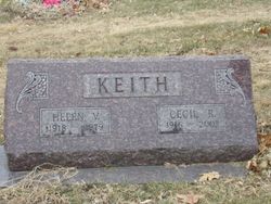
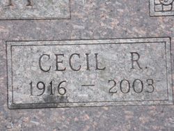
Cecil Raymond Keith
| Birth | : | 14 Nov 1916 |
| Death | : | 24 Mar 2003 Goodman, McDonald County, Missouri, USA |
| Burial | : | Evergreen Cemetery, Red Oak, Montgomery County, USA |
| Coordinate | : | 41.0228004, -95.2205963 |
| Plot | : | ROJ 226 6 |
| Description | : | Married to Linda in 1936 |
frequently asked questions (FAQ):
-
Where is Cecil Raymond Keith's memorial?
Cecil Raymond Keith's memorial is located at: Evergreen Cemetery, Red Oak, Montgomery County, USA.
-
When did Cecil Raymond Keith death?
Cecil Raymond Keith death on 24 Mar 2003 in Goodman, McDonald County, Missouri, USA
-
Where are the coordinates of the Cecil Raymond Keith's memorial?
Latitude: 41.0228004
Longitude: -95.2205963
Family Members:
Parent
Spouse
Siblings


Children
Flowers:


Nearby Cemetories:
1. Evergreen Cemetery
Red Oak, Montgomery County, USA
Coordinate: 41.0228004, -95.2205963
2. Saint Marys Cemetery
Red Oak, Montgomery County, USA
Coordinate: 41.0447006, -95.2275009
3. Shank Cemetery
Red Oak, Montgomery County, USA
Coordinate: 41.0019500, -95.1918300
4. Saint Clair Cemetery
Red Oak Township, Montgomery County, USA
Coordinate: 41.0598400, -95.2049810
5. Hewitt Cemetery
Red Oak, Montgomery County, USA
Coordinate: 40.9850006, -95.2335968
6. Frankfort Cemetery
Montgomery County, USA
Coordinate: 41.0271988, -95.1327972
7. Haefflick Burial Site
Red Oak, Montgomery County, USA
Coordinate: 41.0726300, -95.1561700
8. L Laire Property Cemetery (Defunct)
Sherman Township, Montgomery County, USA
Coordinate: 41.0958257, -95.2224927
9. Indian Graveyard
Sherman Township, Montgomery County, USA
Coordinate: 41.0955730, -95.1837580
10. Salem Cemetery
Red Oak, Montgomery County, USA
Coordinate: 40.9733009, -95.3088989
11. Mamrelund Cemetery
Stanton, Montgomery County, USA
Coordinate: 40.9810486, -95.0959320
12. Mamre Cemetery
Stanton, Montgomery County, USA
Coordinate: 40.9865480, -95.0886400
13. Gomer Cemetery
Wales, Montgomery County, USA
Coordinate: 41.1171989, -95.3082962
14. Lowens Cemetery
Garfield Township, Montgomery County, USA
Coordinate: 41.0527728, -95.3758292
15. Mission Cemetery
Montgomery County, USA
Coordinate: 41.0052986, -95.0603027
16. Tabor Cemetery
Wallin, Montgomery County, USA
Coordinate: 41.0543700, -95.0619900
17. Pilot Grove Presbyterian Cemetery
Wallin, Montgomery County, USA
Coordinate: 41.0793991, -95.0699997
18. Hillside Cemetery
Elliott, Montgomery County, USA
Coordinate: 41.1408005, -95.1544037
19. Center Ridge Cemetery
Montgomery County, USA
Coordinate: 41.1452141, -95.2787018
20. Plum Thicket Cemetery
Nyman, Page County, USA
Coordinate: 40.8916600, -95.2058208
21. Pilot Grove Center Cemetery
Elliott, Montgomery County, USA
Coordinate: 41.1190600, -95.0993700
22. Walnut Cemetery
Montgomery County, USA
Coordinate: 40.9519005, -95.3741989
23. Emerson Cemetery
Emerson, Mills County, USA
Coordinate: 41.0325012, -95.4021988
24. Mount Hope Cemetery
Nyman, Page County, USA
Coordinate: 40.8788986, -95.2046967