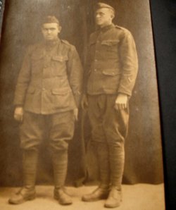
Cecil S Staten
| Birth | : | 25 Oct 1891 Filley, Cedar County, Missouri, USA |
| Death | : | 20 Sep 1921 Yell County, Arkansas, USA |
| Burial | : | Mount Calvary Cemetery, De Pere, Brown County, USA |
| Coordinate | : | 44.4572144, -88.0992661 |
| Inscription | : | Mother-Hannah McMilin(McMillin) |
| Description | : | Birth ca December 1882 World War I Ark Corpl Quartermaster |
frequently asked questions (FAQ):
-
Where is Cecil S Staten's memorial?
Cecil S Staten's memorial is located at: Mount Calvary Cemetery, De Pere, Brown County, USA.
-
When did Cecil S Staten death?
Cecil S Staten death on 20 Sep 1921 in Yell County, Arkansas, USA
-
Where are the coordinates of the Cecil S Staten's memorial?
Latitude: 44.4572144
Longitude: -88.0992661
Family Members:
Parent
Spouse
Siblings
Flowers:
Thank you for your service.
Left by Anonymous on 10 Aug 2017

Left by Anonymous on 03 Sep 2010
Father-Oliver Newton StatenMother-Hannah McMillen StatenBorn Missouri-1891Married- Lula East
Left by Anonymous on 23 Sep 2010

Left by Anonymous on 01 Jul 2014
Honor them by remembering them
Left by Anonymous on 04 Jul 2014

The picture is of brothers William Staten and Cecil Staten during WWI. Cecil was 7' tall
Left by Anonymous on 25 Oct 2017
Left by Anonymous on 30 Nov 2017
Left by Anonymous on 11 Feb 2021
Nearby Cemetories:
1. Mount Calvary Cemetery
De Pere, Brown County, USA
Coordinate: 44.4572144, -88.0992661
2. Cady Cemetery
De Pere, Brown County, USA
Coordinate: 44.4346800, -88.1198100
3. De Pere Greenwood Cemetery
De Pere, Brown County, USA
Coordinate: 44.4308014, -88.0693970
4. Ashwaubenon Moravian Cemetery
Green Bay, Brown County, USA
Coordinate: 44.4930110, -88.0984300
5. Mount Olivet Catholic Cemetery
De Pere, Brown County, USA
Coordinate: 44.4392014, -88.0543976
6. Saint Norbert Abbey Cemetery
De Pere, Brown County, USA
Coordinate: 44.4573300, -88.0465100
7. Saint Annes Memorial Garden
De Pere, Brown County, USA
Coordinate: 44.4401100, -88.0370000
8. Saint Johns Lutheran Cemetery of Ashwaubenon
Green Bay, Brown County, USA
Coordinate: 44.5033610, -88.1191380
9. Allouez Catholic Cemetery And Chapel Mausoleum
Green Bay, Brown County, USA
Coordinate: 44.4824982, -88.0263977
10. Oneida Sacred Burial Grounds
Oneida, Brown County, USA
Coordinate: 44.4724400, -88.1811600
11. Saint Michaels Cemetery
De Pere, Brown County, USA
Coordinate: 44.3968000, -88.1197000
12. Woodlawn Cemetery
Green Bay, Brown County, USA
Coordinate: 44.4902992, -88.0175018
13. Bristol Cemetery
De Pere, Brown County, USA
Coordinate: 44.4149430, -88.0215805
14. Holy Apostles Church Cemetery
Oneida, Brown County, USA
Coordinate: 44.4945984, -88.1825027
15. Union Congregational Church Memorial Garden
Green Bay, Brown County, USA
Coordinate: 44.5045890, -88.0184980
16. La Baye Burial Place
Green Bay, Brown County, USA
Coordinate: 44.5095370, -88.0176650
17. Zion Lutheran Cemetery
Oneida, Brown County, USA
Coordinate: 44.5175018, -88.1716995
18. Garden of Grace
Green Bay, Brown County, USA
Coordinate: 44.5096300, -88.0139260
19. Latter Day Saints Cemetery
Chicago Corners, Outagamie County, USA
Coordinate: 44.5038030, -88.1913670
20. Saint Joseph Cemetery
Chicago Corners, Outagamie County, USA
Coordinate: 44.4850006, -88.2082977
21. Saint Francis Xavier Roman Catholic Cathedral
Green Bay, Brown County, USA
Coordinate: 44.5112376, -88.0113732
22. United Methodist Cemetery
Oneida, Outagamie County, USA
Coordinate: 44.4553900, -88.2181600
23. Church of Christ Cemetery
Chicago Corners, Outagamie County, USA
Coordinate: 44.4441986, -88.2230988
24. Oneida Assembly of God Cemetery
Oneida, Outagamie County, USA
Coordinate: 44.5035400, -88.2109900


