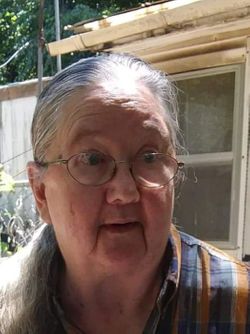
Celia Ines Crotts Tate
| Birth | : | 18 Apr 1943 Carroll County, Virginia, USA |
| Death | : | 20 Aug 2019 Mount Airy, Surry County, North Carolina, USA |
| Burial | : | Sandy Ridge Primitive Baptist Church Cemetery, Cana, Carroll County, USA |
| Coordinate | : | 36.6089030, -80.7131890 |
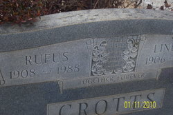
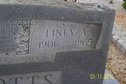
| Description | : | Mrs. Celia Ines Crotts Tate, age 76, of Mt. Airy, passed away on Tuesday, August 20, 2019, at Northern Hospital of Surry County. She was born April 18, 1943, to the late Rufus McDaniel and Lynne Allen Crotts. She was a loving mother and grandmother who will surely be missed by all who knew her. Left to cherish her memories are a daughter and son-in-law, Phyllis and Paul Willard; son and daughter-in-law, Harry and Lilli Tate; grandchildren: Cody Tate, Cory Tate, Larry Tate, Samantha Willard, Nora Willard, Crystal Willard, Margaret Brown, Amy Campbell, Britany... Read More |
frequently asked questions (FAQ):
-
Where is Celia Ines Crotts Tate's memorial?
Celia Ines Crotts Tate's memorial is located at: Sandy Ridge Primitive Baptist Church Cemetery, Cana, Carroll County, USA.
-
When did Celia Ines Crotts Tate death?
Celia Ines Crotts Tate death on 20 Aug 2019 in Mount Airy, Surry County, North Carolina, USA
-
Where are the coordinates of the Celia Ines Crotts Tate's memorial?
Latitude: 36.6089030
Longitude: -80.7131890
Family Members:
Parent
Spouse
Siblings
Children
Flowers:
Nearby Cemetories:
1. Sandy Ridge Primitive Baptist Church Cemetery
Cana, Carroll County, USA
Coordinate: 36.6089030, -80.7131890
2. Frances Caroline Edwards Family Cemetery
Cana, Carroll County, USA
Coordinate: 36.6089000, -80.7193140
3. Nathaniel Samuel Jones Family Cemetery
Cana, Carroll County, USA
Coordinate: 36.6047060, -80.7186010
4. Jones-Fleming Cemetery
Carroll County, USA
Coordinate: 36.6012360, -80.7114230
5. King Cemetery
Cana, Carroll County, USA
Coordinate: 36.6170430, -80.7070900
6. Pauls Creek Baptist Church Cemetery
Cana, Carroll County, USA
Coordinate: 36.6072870, -80.6976360
7. Marion Cemetery
Cana, Carroll County, USA
Coordinate: 36.6055090, -80.7284550
8. Fancy Gap Pentecostal Holiness Church Cemetery
Cana, Carroll County, USA
Coordinate: 36.6227090, -80.7150880
9. Claucy William Hawks Family Cemetery
Cana, Carroll County, USA
Coordinate: 36.6236190, -80.7151980
10. King Family Cemetery
Cana, Carroll County, USA
Coordinate: 36.6211420, -80.7020900
11. King-Jones Cemetery
Cana, Carroll County, USA
Coordinate: 36.6224890, -80.7033540
12. Gray Cemetery
Cana, Carroll County, USA
Coordinate: 36.5943420, -80.7034040
13. Edwards Cemetery
Cana, Carroll County, USA
Coordinate: 36.6154480, -80.6904890
14. Rocky Ford Christian Church Cemetery
Cana, Carroll County, USA
Coordinate: 36.6080580, -80.6857110
15. Flower Gap Primitive Baptist Church Cemetery
Cana, Carroll County, USA
Coordinate: 36.5900510, -80.7286500
16. George Jeremiah Edwards Family Cemetery
Cana, Carroll County, USA
Coordinate: 36.5937600, -80.7370100
17. Vernon-Leonard Cemetery
Cana, Carroll County, USA
Coordinate: 36.5841200, -80.7217600
18. Easter Family Cemetery
Carroll County, USA
Coordinate: 36.5900270, -80.7354860
19. Cedar Lane-Easter Cemetery
Cana, Carroll County, USA
Coordinate: 36.5898610, -80.7356070
20. McCraw Family Cemetery
Lambsburg, Carroll County, USA
Coordinate: 36.5814200, -80.7235270
21. Christopher W Jones Cemetery
Cana, Carroll County, USA
Coordinate: 36.5819178, -80.7000292
22. Rigney Family Cemetery
Cana, Carroll County, USA
Coordinate: 36.6233650, -80.6806990
23. Johnson-Leftwich Cemetery
Fancy Gap, Carroll County, USA
Coordinate: 36.6331620, -80.7381820
24. Leftwich Family Cemetery
Cana, Carroll County, USA
Coordinate: 36.6211110, -80.6758350


