
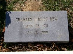
Charles Bolles Dew
| Birth | : | 28 Sep 1921 New Hanover County, North Carolina, USA |
| Death | : | 11 Jan 2000 Latta, Dillon County, South Carolina, USA |
| Burial | : | Louisa Jane Methodist Chapel Cemetery, Alkires Mills, Lewis County, USA |
| Coordinate | : | 38.9786900, -80.4260310 |
| Description | : | WWII veteran. |
frequently asked questions (FAQ):
-
Where is Charles Bolles Dew's memorial?
Charles Bolles Dew's memorial is located at: Louisa Jane Methodist Chapel Cemetery, Alkires Mills, Lewis County, USA.
-
When did Charles Bolles Dew death?
Charles Bolles Dew death on 11 Jan 2000 in Latta, Dillon County, South Carolina, USA
-
Where are the coordinates of the Charles Bolles Dew's memorial?
Latitude: 38.9786900
Longitude: -80.4260310
Family Members:
Parent
Spouse
Siblings
Flowers:


Nearby Cemetories:
1. Louisa Jane Methodist Chapel Cemetery
Alkires Mills, Lewis County, USA
Coordinate: 38.9786900, -80.4260310
2. Glady Cemetery
Horner, Lewis County, USA
Coordinate: 38.9846992, -80.4389038
3. Corathers Cemetery
Lewis County, USA
Coordinate: 38.9693927, -80.4128386
4. Georgetown Cemetery
Lewis County, USA
Coordinate: 38.9638000, -80.3835200
5. Bush Cemetery
Horner, Lewis County, USA
Coordinate: 39.0147018, -80.4021988
6. Horner Methodist Church Cemetery
Weston, Lewis County, USA
Coordinate: 39.0041069, -80.3845373
7. Peterson Cemetery
Weston, Lewis County, USA
Coordinate: 39.0224991, -80.4244003
8. Lewis County Memorial Gardens
Weston, Lewis County, USA
Coordinate: 39.0224390, -80.4202340
9. Brownsville Cemetery
Lewis County, USA
Coordinate: 39.0163994, -80.4756012
10. Vandalia Cemetery
Vandalia, Lewis County, USA
Coordinate: 38.9284930, -80.3999790
11. Rockford-Pletcher Cemetery (Defunct)
Lewis County, USA
Coordinate: 38.9817009, -80.4963989
12. Briar Point Cemetery
Walkersville, Lewis County, USA
Coordinate: 38.9438170, -80.4905950
13. Paul T Mitchell Cemetery
Roanoke, Lewis County, USA
Coordinate: 38.9437210, -80.4905340
14. Miller Cemetery
Horner, Lewis County, USA
Coordinate: 39.0022800, -80.3496370
15. Ward Cemetery
Lewis County, USA
Coordinate: 38.9975860, -80.5051990
16. Old Arnold Cemetery
Weston, Lewis County, USA
Coordinate: 39.0350120, -80.4693550
17. Whitesell Cemetery
Lewis County, USA
Coordinate: 38.9307760, -80.4844406
18. William L. Smith Cemetery
Roanoke, Lewis County, USA
Coordinate: 38.9228820, -80.4715130
19. Fairview Cemetery
Roanoke, Lewis County, USA
Coordinate: 38.9306000, -80.4847000
20. Smith Family Cemetery
Lewis County, USA
Coordinate: 39.0457993, -80.4297028
21. Smiths Run Cemetery
Weston, Lewis County, USA
Coordinate: 39.0463070, -80.4173810
22. Weston State Hospital Cemetery
Weston, Lewis County, USA
Coordinate: 39.0395050, -80.4727760
23. Middle Run Cemetery
Weston, Lewis County, USA
Coordinate: 39.0149994, -80.5081024
24. Mount Olive Church Cemetery
Weston, Lewis County, USA
Coordinate: 38.9285020, -80.3567790