
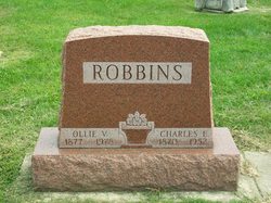
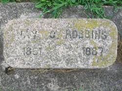
Charles E. Robbins
| Birth | : | 18 Apr 1870 Fulton County, Indiana, USA |
| Death | : | 14 Jun 1952 Rochester, Fulton County, Indiana, USA |
| Burial | : | Tarwin Lower Cemetery, Tarwin Lower, South Gippsland Shire, Australia |
| Coordinate | : | -38.6710420, 145.8624400 |
| Plot | : | Section 6, Row 7 |
| Description | : | Published in the Rochester(IN) News-Sentinel, Saturday, June 14, 1952 Charles E. ROBBINS, 82, well known farm implement dealer died at 10:30 Saturday morning at his home, 331 W. 11th street, following an illness of two years with coronary thrombosis. He had been bedfast for the past nine months. Born on a farm in Fulton county April 18, 1870, he was the son of Silas H. and Sarah ROBBINS. He had been a Rochester businessman for fifty years, engaging in the restaurant, auto and implement business during that time. With the exception of six years residence in California, Mr. Robbins had... Read More |
frequently asked questions (FAQ):
-
Where is Charles E. Robbins's memorial?
Charles E. Robbins's memorial is located at: Tarwin Lower Cemetery, Tarwin Lower, South Gippsland Shire, Australia.
-
When did Charles E. Robbins death?
Charles E. Robbins death on 14 Jun 1952 in Rochester, Fulton County, Indiana, USA
-
Where are the coordinates of the Charles E. Robbins's memorial?
Latitude: -38.6710420
Longitude: 145.8624400
Family Members:
Parent
Spouse

Siblings
Children
Flowers:


Nearby Cemetories:
1. Tarwin Lower Cemetery
Tarwin Lower, South Gippsland Shire, Australia
Coordinate: -38.6710420, 145.8624400
2. Inverloch Cemetery
Inverloch, Bass Coast Shire, Australia
Coordinate: -38.6273780, 145.7185850
3. Meeniyan Cemetery
Meeniyan, South Gippsland Shire, Australia
Coordinate: -38.5782080, 146.0204130
4. Outtrim Cemetery
Outtrim, South Gippsland Shire, Australia
Coordinate: -38.5122130, 145.7768440
5. Walkerville Cemetery
South Gippsland Shire, Australia
Coordinate: -38.8563610, 145.9096350
6. Leongatha Cemetery
Leongatha, South Gippsland Shire, Australia
Coordinate: -38.4831187, 145.9380932
7. Wonthaggi Cemetery
Wonthaggi, Bass Coast Shire, Australia
Coordinate: -38.6211128, 145.5833282
8. Coal Creek Community Park and Museum
Korumburra, South Gippsland Shire, Australia
Coordinate: -38.4438019, 145.8312988
9. Korumburra Cemetery
Korumburra, South Gippsland Shire, Australia
Coordinate: -38.4303000, 145.8482100
10. Foster Cemetery
Foster, South Gippsland Shire, Australia
Coordinate: -38.6584961, 146.1906258
11. Kilcunda Cemetery
Kilcunda, Bass Coast Shire, Australia
Coordinate: -38.5590700, 145.4918990
12. Toora Cemetery
Toora, South Gippsland Shire, Australia
Coordinate: -38.6702650, 146.2836720
13. Poowong Cemetery
Poowong, South Gippsland Shire, Australia
Coordinate: -38.3461002, 145.7615830
14. Yanakie Station Cemetery
Yanakie, South Gippsland Shire, Australia
Coordinate: -38.8599510, 146.2427020
15. Allambee East Cemetery
Allambee South, South Gippsland Shire, Australia
Coordinate: -38.3594710, 146.0860860
16. Mirboo North Cemetery
South Gippsland Shire, Australia
Coordinate: -38.4030220, 146.1725580
17. Nyora Cemetery
Nyora, South Gippsland Shire, Australia
Coordinate: -38.3406970, 145.6637270
18. Grantville Cemetery
Grantville, Bass Coast Shire, Australia
Coordinate: -38.3947460, 145.5398240
19. Corinella Cemetery
Corinella, Bass Coast Shire, Australia
Coordinate: -38.4361780, 145.4847240
20. San Remo Cemetery
San Remo, Bass Coast Shire, Australia
Coordinate: -38.5264220, 145.3794970
21. San Remo Fisherman Lost at Sea
San Remo, Bass Coast Shire, Australia
Coordinate: -38.5204271, 145.3646088
22. Boolarra Cemetery
Boolarra, Latrobe City, Australia
Coordinate: -38.3941880, 146.2667690
23. Childers and Thorpdale Cemetery
Thorpdale, Baw Baw Shire, Australia
Coordinate: -38.3060020, 146.1422990
24. Lang Lang Cemetery
Lang Lang, Cardinia Shire, Australia
Coordinate: -38.2779980, 145.5831970