

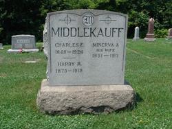
Charles Edward Middlekauff
| Birth | : | 31 Jul 1848 Maryland, USA |
| Death | : | 22 Apr 1926 Harrisburg, Dauphin County, Pennsylvania, USA |
| Burial | : | Liverpool Road Cemetery, Birkdale, Metropolitan Borough of Sefton, England |
| Coordinate | : | 53.6083620, -3.0257140 |
| Description | : | Charles Edward Middlekauff, aged 78 years, who conducted a shoemaker shop in Walnut street, this city, for 40 years, died at the Harrisburg hospital Thursday morning. Mr. Middlekauff, who has made his home with his daughter, Mrs. Geo. D. Gelwicks, 30 South 17th Street, Harrisburg, for the past eleven years, was in excellent health up to a few weeks ago when he sustained a fall. His condition became critical on Tuesday and he was removed to the hospital on Wednesday. Mr. Middlekauff is survived by one son, Frank, of Philadelphia, and one daughter, Mrs. Gelwicks, Harrisburg. He was member of Resoluts Council... Read More |
frequently asked questions (FAQ):
-
Where is Charles Edward Middlekauff's memorial?
Charles Edward Middlekauff's memorial is located at: Liverpool Road Cemetery, Birkdale, Metropolitan Borough of Sefton, England.
-
When did Charles Edward Middlekauff death?
Charles Edward Middlekauff death on 22 Apr 1926 in Harrisburg, Dauphin County, Pennsylvania, USA
-
Where are the coordinates of the Charles Edward Middlekauff's memorial?
Latitude: 53.6083620
Longitude: -3.0257140
Family Members:
Parent
Spouse

Siblings
Children
Flowers:


Nearby Cemetories:
1. Liverpool Road Cemetery
Birkdale, Metropolitan Borough of Sefton, England
Coordinate: 53.6083620, -3.0257140
2. Sacred Heart RC Cemetery
Birkdale, Metropolitan Borough of Sefton, England
Coordinate: 53.6066100, -3.0270100
3. Christ Church Churchyard
Southport, Metropolitan Borough of Sefton, England
Coordinate: 53.6327778, -2.9953770
4. Duke Street Cemetery
Southport, Metropolitan Borough of Sefton, England
Coordinate: 53.6343536, -2.9993131
5. Ardwick Cemetery
Ardwick, Metropolitan Borough of Manchester, England
Coordinate: 53.6302778, -2.9900000
6. Southport Crematorium
Scarisbrick, West Lancashire District, England
Coordinate: 53.6235810, -2.9600210
7. Holy Trinity Church
Southport, Metropolitan Borough of Sefton, England
Coordinate: 53.6503800, -2.9969150
8. St. Marie on the Sands
Southport, Metropolitan Borough of Sefton, England
Coordinate: 53.6524320, -3.0023440
9. St. Peter's Churchyard
Formby, Metropolitan Borough of Sefton, England
Coordinate: 53.5663834, -3.0594721
10. St. Cuthbert's Churchyard
Halsall, West Lancashire District, England
Coordinate: 53.5852140, -2.9529650
11. St. Mark Churchyard
Scarisbrick, West Lancashire District, England
Coordinate: 53.6134600, -2.9403800
12. Our Lady Of Compassion RC Churchyard
Formby, Metropolitan Borough of Sefton, England
Coordinate: 53.5574060, -3.0575020
13. St. Michael and All Angels Churchyard
Great Altcar, Metropolitan Borough of Sefton, England
Coordinate: 53.5507770, -3.0279540
14. Emmanuel Parish Church
Southport, Metropolitan Borough of Sefton, England
Coordinate: 53.6604534, -2.9748117
15. Emmanuel Church Garden of Remembrance
North Meols, West Lancashire District, England
Coordinate: 53.6607130, -2.9753420
16. St. Elizabeth's Churchyard
Scarisbrick, West Lancashire District, England
Coordinate: 53.6124460, -2.9206340
17. St Cuthberts Churchyard
Southport, Metropolitan Borough of Sefton, England
Coordinate: 53.6603230, -2.9620310
18. St. Luke Churchyard
Formby, Metropolitan Borough of Sefton, England
Coordinate: 53.5520000, -3.0869800
19. St Thomas Churchyard
Lydiate, Metropolitan Borough of Sefton, England
Coordinate: 53.5443480, -2.9621640
20. Our Lady's Roman Catholic Churchyard
Lydiate, Metropolitan Borough of Sefton, England
Coordinate: 53.5396850, -2.9599940
21. Saint John Crossens Churchyard
Crossens, Metropolitan Borough of Sefton, England
Coordinate: 53.6733410, -2.9478740
22. St Catherine Churchyard
Lydiate, Metropolitan Borough of Sefton, England
Coordinate: 53.5368000, -2.9612660
23. Ince Blundell Cemetery
Ince Blundell, Metropolitan Borough of Sefton, England
Coordinate: 53.5213570, -3.0208750
24. Christ Churchyard
Aughton, West Lancashire District, England
Coordinate: 53.5583510, -2.9046990