

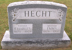
Charles Fredrick Hecht
| Birth | : | 10 Aug 1873 Moniteau County, Missouri, USA |
| Death | : | 22 Apr 1959 Jefferson City, Cole County, Missouri, USA |
| Burial | : | Olean Cemetery, Olean, Miller County, USA |
| Coordinate | : | 38.4131012, -92.5413971 |
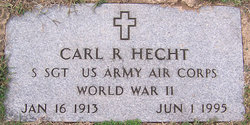
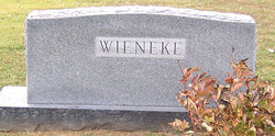
| Description | : | Daily Capital News, Friday, April 24, 1959, Jefferson City, Missouri Services will be at 2 p.m. today at Olean Christian Church for Charles Hecht, 85, retired farmer, who died Wednesday at St. Mary's Hospital in Jefferson City. The Rev. Alfred Scott will officiate with burial in Olean Cemetery. Born Aug. 18, 1873, he was married Feb. 22, 1899, to the former Miss Emma Rentsch, who died Dec. 10. 1958. Surviving are four daughters, Mrs. Marie Miller, LaJolla, Calif.; Mrs. Helen Finley, St. Louis; Mrs. Pauline Wieneke, Seattle, Wash.; and Mrs. Brenda Hocker, Kansas City; three sons, Henry Hecht, St. Louis; Herbert Hecht, Olean;... Read More |
frequently asked questions (FAQ):
-
Where is Charles Fredrick Hecht's memorial?
Charles Fredrick Hecht's memorial is located at: Olean Cemetery, Olean, Miller County, USA.
-
When did Charles Fredrick Hecht death?
Charles Fredrick Hecht death on 22 Apr 1959 in Jefferson City, Cole County, Missouri, USA
-
Where are the coordinates of the Charles Fredrick Hecht's memorial?
Latitude: 38.4131012
Longitude: -92.5413971
Family Members:
Spouse
Children
Flowers:


Nearby Cemetories:
1. Olean Cemetery
Olean, Miller County, USA
Coordinate: 38.4131012, -92.5413971
2. Green Ridge Baptist Church Cemetery
Eldon, Miller County, USA
Coordinate: 38.4116200, -92.5645700
3. Etter-Walker Cemetery
Burris Fork, Moniteau County, USA
Coordinate: 38.4333700, -92.5525400
4. Walker Cemetery
Moniteau County, USA
Coordinate: 38.4338989, -92.5522003
5. Farris Cemetery
Moniteau County, USA
Coordinate: 38.4369900, -92.5380000
6. Allen Cemetery
Olean, Miller County, USA
Coordinate: 38.4150009, -92.5008011
7. Jackson Chapel Methodist Church Cemetery
California, Moniteau County, USA
Coordinate: 38.4447900, -92.5286500
8. Gray Cemetery
Moniteau County, USA
Coordinate: 38.4536018, -92.5456009
9. Hite Cemetery
Miller County, USA
Coordinate: 38.4039001, -92.5935974
10. Mount Pleasant Cemetery
Eldon, Miller County, USA
Coordinate: 38.3667700, -92.5300800
11. Salem Cemetery
Saline Township, Miller County, USA
Coordinate: 38.3691232, -92.5697260
12. Salem Cemetery
Eldon, Miller County, USA
Coordinate: 38.3697014, -92.5714035
13. Mount Vernon Cemetery
Eldon, Miller County, USA
Coordinate: 38.3624992, -92.5606003
14. Bruce-Lewis-McGahan Cemetery
Enon, Moniteau County, USA
Coordinate: 38.4667500, -92.5172100
15. Rock Enon Cemetery
Miller County, USA
Coordinate: 38.4668400, -92.5170700
16. Eldon Cemetery
Eldon, Miller County, USA
Coordinate: 38.3642006, -92.5868988
17. Phillips Cemetery
High Point, Moniteau County, USA
Coordinate: 38.4430300, -92.6125300
18. Colburn Cemetery
Eldon, Miller County, USA
Coordinate: 38.4246300, -92.6275500
19. Depp Cemetery
High Point, Moniteau County, USA
Coordinate: 38.4776400, -92.5818500
20. High Point Cemetery
High Point, Moniteau County, USA
Coordinate: 38.4817009, -92.5757980
21. Phillips Cemetery
Barnett, Morgan County, USA
Coordinate: 38.4227982, -92.6367035
22. Matheis Cemetery
Russellville, Cole County, USA
Coordinate: 38.4571800, -92.4491600
23. United Baptist Church Cemetery
High Point, Moniteau County, USA
Coordinate: 38.4962200, -92.5856800
24. Karnes-Carney-Henderson Cemetery
Burris Fork, Moniteau County, USA
Coordinate: 38.4992100, -92.5007510