
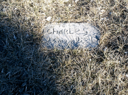
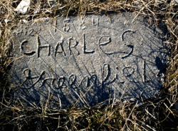

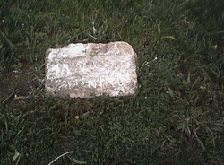
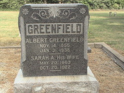
Charles Greenfield
| Birth | : | 1842 Canada |
| Death | : | 1893 Franklin County, Kansas, USA |
| Burial | : | Dean Cemetery, Pomona, Franklin County, USA |
| Coordinate | : | 38.7038994, -95.4781036 |
| Description | : | The 1861 Canadian Census shows Charles with his mother and siblings in Brantford County, Ontario, Canada. In 1876 a marriage license was issued to Martha and Charles at the Courthouse in Douglas County. The settled on a farm in Franklin County. An 1890 Gazetter shows it as a 90 Acre farm located 3/4 mile south of the Franklin County, Douglas County Line; and 1 mile east of the Osage County, Franklin County line.. According to his second son, Thomas, Charles died when he was 13. He remembered it being very cold that day. The current home made stone... Read More |
frequently asked questions (FAQ):
-
Where is Charles Greenfield's memorial?
Charles Greenfield's memorial is located at: Dean Cemetery, Pomona, Franklin County, USA.
-
When did Charles Greenfield death?
Charles Greenfield death on 1893 in Franklin County, Kansas, USA
-
Where are the coordinates of the Charles Greenfield's memorial?
Latitude: 38.7038994
Longitude: -95.4781036
Family Members:
Parent
Spouse

Siblings
Children
Flowers:


Nearby Cemetories:
1. Dean Cemetery
Pomona, Franklin County, USA
Coordinate: 38.7038994, -95.4781036
2. Appanoose Cemetery
Globe, Douglas County, USA
Coordinate: 38.7392006, -95.4642029
3. Pleasant Hill Cemetery
Centropolis, Franklin County, USA
Coordinate: 38.7243996, -95.4021988
4. Pleasant Ridge Cemetery
Osage County, USA
Coordinate: 38.6492004, -95.5271988
5. Kaub Cemetery
Centropolis, Franklin County, USA
Coordinate: 38.7172012, -95.3899994
6. Valley Brook Cemetery
Michigan Valley, Osage County, USA
Coordinate: 38.7242279, -95.5646362
7. Dodder Cemetery
Baldwin City, Douglas County, USA
Coordinate: 38.7827988, -95.4452972
8. Overbrook Cemetery
Overbrook, Osage County, USA
Coordinate: 38.7751083, -95.5487442
9. Union Cemetery
Globe, Douglas County, USA
Coordinate: 38.7407800, -95.3713000
10. Woodlawn Cemetery
Pomona, Franklin County, USA
Coordinate: 38.6100006, -95.4681015
11. Parkinson Cemetery
Franklin County, USA
Coordinate: 38.6479500, -95.3804800
12. Centropolis Cemetery
Centropolis, Franklin County, USA
Coordinate: 38.7242737, -95.3525009
13. Eastview Cemetery
Quenemo, Osage County, USA
Coordinate: 38.6081009, -95.5235977
14. Mount Zion Cemetery
Vassar, Osage County, USA
Coordinate: 38.6796989, -95.6181030
15. Minneola Cemetery
Centropolis, Franklin County, USA
Coordinate: 38.7036200, -95.3345900
16. Lamont Hill Cemetery
Vassar, Osage County, USA
Coordinate: 38.6392400, -95.6004600
17. Oak Hill Cemetery
Quenemo, Osage County, USA
Coordinate: 38.5918999, -95.5333023
18. Foster Cemetery
Ottawa, Franklin County, USA
Coordinate: 38.6651390, -95.3324460
19. Salt Creek Cemetery
Osage County, USA
Coordinate: 38.6164100, -95.5875300
20. Bethel Cemetery
Worden, Douglas County, USA
Coordinate: 38.7675018, -95.3439026
21. Nightingale Farm Cemetery
Pomona, Franklin County, USA
Coordinate: 38.5815300, -95.4409300
22. Vassar Cemetery
Osage County, USA
Coordinate: 38.6408005, -95.6192017
23. Greenwood Cemetery
Franklin County, USA
Coordinate: 38.5781700, -95.4145900
24. Washington Creek Cemetery
Lone Star, Douglas County, USA
Coordinate: 38.8273800, -95.3997900