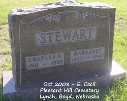
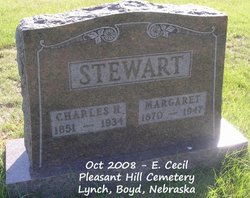
Charles Harrison Stewart
| Birth | : | 1851 Ray County, Missouri, USA |
| Death | : | 4 Feb 1934 Lynch, Boyd County, Nebraska, USA |
| Burial | : | Mount Calvary Cemetery, Wheeling, Ohio County, USA |
| Coordinate | : | 40.0602989, -80.6710968 |
| Description | : | Son of William A. and Delphia C. Stewart, and married Margaret Draine on Oct. 10, 1888 in Springview, Nebraska. extended d date and geographic info, and middle name provided |
frequently asked questions (FAQ):
-
Where is Charles Harrison Stewart's memorial?
Charles Harrison Stewart's memorial is located at: Mount Calvary Cemetery, Wheeling, Ohio County, USA.
-
When did Charles Harrison Stewart death?
Charles Harrison Stewart death on 4 Feb 1934 in Lynch, Boyd County, Nebraska, USA
-
Where are the coordinates of the Charles Harrison Stewart's memorial?
Latitude: 40.0602989
Longitude: -80.6710968
Family Members:
Parent
Spouse
Siblings
Children
Flowers:
Nearby Cemetories:
1. Mount Calvary Cemetery
Wheeling, Ohio County, USA
Coordinate: 40.0602989, -80.6710968
2. Greenwood Cemetery
Wheeling, Ohio County, USA
Coordinate: 40.0619200, -80.6793100
3. Mount de Chantal Visitation Cemetery
Wheeling, Ohio County, USA
Coordinate: 40.0686640, -80.6951520
4. Stone Church Cemetery
Wheeling, Ohio County, USA
Coordinate: 40.0416985, -80.6530991
5. East Wheeling Cemetery
Wheeling, Ohio County, USA
Coordinate: 40.0650270, -80.7130310
6. Parkview Memorial Gardens
Wheeling, Ohio County, USA
Coordinate: 40.0917015, -80.6560974
7. Our Lady of Seven Dolors Cemetery
Triadelphia, Ohio County, USA
Coordinate: 40.0543404, -80.6280594
8. Mount Zion Cemetery
Wheeling, Ohio County, USA
Coordinate: 40.0452995, -80.7136002
9. Gregg Cemetery
Greggsville, Ohio County, USA
Coordinate: 40.0942001, -80.6881027
10. Peninsula Cemetery
Wheeling, Ohio County, USA
Coordinate: 40.0758000, -80.7144000
11. Mount Olivet Cemetery
Mount Olivet, Marshall County, USA
Coordinate: 40.0269012, -80.6952972
12. Red Mens Cemetery
Ohio County, USA
Coordinate: 40.0550500, -80.7219000
13. Mount Wood Cemetery
Wheeling, Ohio County, USA
Coordinate: 40.0814018, -80.7225037
14. Jewish Memorial Park
Ohio County, USA
Coordinate: 40.0419700, -80.6107700
15. Walnut Grove Cemetery
Martins Ferry, Belmont County, USA
Coordinate: 40.0999985, -80.7181015
16. Old Tent Cemetery
Wheeling, Ohio County, USA
Coordinate: 40.1090164, -80.6372910
17. Boggs Run Cemetery
Benwood, Marshall County, USA
Coordinate: 40.0259900, -80.7277000
18. Kirkwood Cemetery
Bridgeport, Belmont County, USA
Coordinate: 40.0683320, -80.7427760
19. Roneys Point Cemetery
Wheeling, Ohio County, USA
Coordinate: 40.0932530, -80.6105200
20. Riverview Cemetery
Martins Ferry, Belmont County, USA
Coordinate: 40.1032000, -80.7207600
21. Nelson Cemetery
Bellaire, Belmont County, USA
Coordinate: 40.0321900, -80.7436400
22. Saint Mary's Cemetery
Martins Ferry, Belmont County, USA
Coordinate: 40.0931015, -80.7446976
23. Lawrencefield Parish Church Cemetery
Ohio County, USA
Coordinate: 40.1281310, -80.6615600
24. Henschel Cemetery
Pease Township, Belmont County, USA
Coordinate: 40.1197200, -80.7177840


