
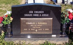
Charles L. "Charlie" Purnell
| Birth | : | 8 Dec 1944 Switzerland County, Indiana, USA |
| Death | : | 3 Aug 2001 Madison, Jefferson County, Indiana, USA |
| Burial | : | St. Mary's Churchyard, Swineshead, Boston Borough, England |
| Coordinate | : | 52.9446490, -0.1596530 |
| Description | : | Madison Courier Madison, Indiana August 6, 2001 Charles L. "Charlie" Purnell, 56, of 306 Tell St., Vevay, died Friday, Aug. 3, 2001, at the King's Daughters' Hospital. He was born Dec. 8, 1944, in Switzerland County, the son of Stanley and Charlotte Coy Purnell-Walker. He was a former employee of the Switzerland County Highway Department, and later worked for 10 years with Kentuckiana Paving Co. in Madison. He had worked the past 16 years as project coordinator supervisor with Ohio Valley Asphalt Co. in Carrollton, Ky. He was a member of Operators Local 181 in Louisville. He was a member of the American Legion,... Read More |
frequently asked questions (FAQ):
-
Where is Charles L. "Charlie" Purnell's memorial?
Charles L. "Charlie" Purnell's memorial is located at: St. Mary's Churchyard, Swineshead, Boston Borough, England.
-
When did Charles L. "Charlie" Purnell death?
Charles L. "Charlie" Purnell death on 3 Aug 2001 in Madison, Jefferson County, Indiana, USA
-
Where are the coordinates of the Charles L. "Charlie" Purnell's memorial?
Latitude: 52.9446490
Longitude: -0.1596530
Family Members:
Parent

Siblings


Nearby Cemetories:
1. St. Mary's Churchyard
Swineshead, Boston Borough, England
Coordinate: 52.9446490, -0.1596530
2. Bicker Cemetery
Bicker, Boston Borough, England
Coordinate: 52.9261110, -0.1794440
3. St. Swithin's Churchyard
Bicker, Boston Borough, England
Coordinate: 52.9242080, -0.1798800
4. St. Peter and St. Paul's Churchyard
Wigtoft, Boston Borough, England
Coordinate: 52.9083330, -0.1236110
5. Donington Old Cemetery
Donington, South Holland District, England
Coordinate: 52.9091670, -0.2055560
6. St. Mary and the Holy Rood Churchyard
Donington, South Holland District, England
Coordinate: 52.9072790, -0.2050080
7. Donington New Cemetery
Donington, South Holland District, England
Coordinate: 52.9071410, -0.2059100
8. St. Margaret's Churchyard
Quadring, South Holland District, England
Coordinate: 52.8903400, -0.1819700
9. St. Mary The Virgin Churchyard
Sutterton, Boston Borough, England
Coordinate: 52.9016700, -0.0911111
10. Kirton in Holland New Cemetery
Kirton, Boston Borough, England
Coordinate: 52.9361110, -0.0597220
11. Sutterton Village Cemetery
Sutterton, Boston Borough, England
Coordinate: 52.8994440, -0.0900000
12. Kirton in Holland Old Cemetery
Kirton, Boston Borough, England
Coordinate: 52.9352780, -0.0583330
13. St. Gilbert of Sempringham
Brothertoft, Boston Borough, England
Coordinate: 52.9987500, -0.1090160
14. Church of St. Peter and St. Paul
Kirton, Boston Borough, England
Coordinate: 52.9280560, -0.0597220
15. St. Peter and St. Paul Churchyard
Algarkirk, Boston Borough, England
Coordinate: 52.8995000, -0.0817800
16. Boston Baptist Cemetery
Boston, Boston Borough, England
Coordinate: 52.9726351, -0.0477945
17. St. Peter and St. Paul Churchyard
Gosberton, South Holland District, England
Coordinate: 52.8690870, -0.1629740
18. Gosberton Cemetery
Gosberton, South Holland District, England
Coordinate: 52.8659400, -0.1623000
19. St. Margaret Churchyard
Langrick, East Lindsey District, England
Coordinate: 53.0206370, -0.1214770
20. St Mary's Churchyard
Frampton, Boston Borough, England
Coordinate: 52.9335410, -0.0289950
21. Gosberton Baptist Church
Gosberton, South Holland District, England
Coordinate: 52.8651820, -0.1533940
22. St. Thomas Churchyard
Skirbeck, Boston Borough, England
Coordinate: 52.9649810, -0.0296080
23. St. Leodegar Churchyard
Wyberton, Boston Borough, England
Coordinate: 52.9480560, -0.0236110
24. Wyberton Cemetery
Wyberton, Boston Borough, England
Coordinate: 52.9480560, -0.0225000