
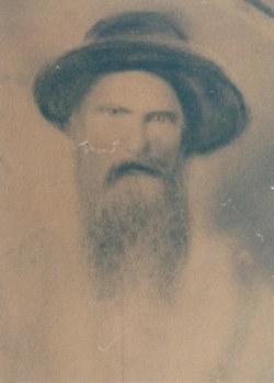
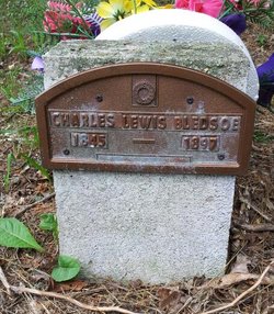
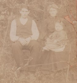
Charles Lewis Bledsoe
| Birth | : | 15 May 1845 Orange County, Virginia, USA |
| Death | : | 1 Jul 1897 Cabell County, West Virginia, USA |
| Burial | : | Eagle Springs United Methodist Church Cemetery, Eagle Springs, Moore County, USA |
| Coordinate | : | 35.2787100, -79.6635030 |
| Description | : | Lewis was a Private in Company G of the 8th Virginia Cavalry in the War Between the States. His grave was unmarked for 102 years until a modest marker was placed for him in 1999. |
frequently asked questions (FAQ):
-
Where is Charles Lewis Bledsoe's memorial?
Charles Lewis Bledsoe's memorial is located at: Eagle Springs United Methodist Church Cemetery, Eagle Springs, Moore County, USA.
-
When did Charles Lewis Bledsoe death?
Charles Lewis Bledsoe death on 1 Jul 1897 in Cabell County, West Virginia, USA
-
Where are the coordinates of the Charles Lewis Bledsoe's memorial?
Latitude: 35.2787100
Longitude: -79.6635030
Family Members:
Parent

Spouse
Siblings
Children

Flowers:


Nearby Cemetories:
1. Eagle Springs United Methodist Church Cemetery
Eagle Springs, Moore County, USA
Coordinate: 35.2787100, -79.6635030
2. Holy Way Church of the Living Word Cemetery
Eagle Springs, Moore County, USA
Coordinate: 35.2913895, -79.6530609
3. Eagle Springs Baptist Church Cemetery
Eagle Springs, Moore County, USA
Coordinate: 35.2916750, -79.6489000
4. Holly Grove Deliverance Church of God Cemetery
Eagle Springs, Moore County, USA
Coordinate: 35.2874390, -79.6354560
5. Allred Family Cemetery
Eagle Springs, Moore County, USA
Coordinate: 35.2990500, -79.6865500
6. Old Center Baptist Church Cemetery
Candor, Montgomery County, USA
Coordinate: 35.2685890, -79.7123450
7. Pleasant Hill United Methodist Church Cemetery
Montgomery County, USA
Coordinate: 35.2409790, -79.6867040
8. Brooks Family Cemetery
Montgomery County, USA
Coordinate: 35.2536300, -79.7197800
9. Belford Baptist Cemetery
Jackson Springs, Moore County, USA
Coordinate: 35.2308350, -79.6986618
10. Belford Church Cemetery
Candor, Montgomery County, USA
Coordinate: 35.2279243, -79.6972612
11. Marsh Chapel AME Zion Church Cemetery
Jackson Springs, Moore County, USA
Coordinate: 35.2229810, -79.6420790
12. Center Baptist Church Cemetery
Candor, Montgomery County, USA
Coordinate: 35.2692420, -79.7370590
13. Seven Lakes Cemetery
Seven Lakes, Moore County, USA
Coordinate: 35.2701240, -79.5895770
14. Providence Presbyterian Church Cemetery
Jackson Springs, Moore County, USA
Coordinate: 35.2198140, -79.6376120
15. Copeland Family Cemetery
Jackson Springs, Moore County, USA
Coordinate: 35.2108139, -79.6575778
16. Big Oak Christian Church Cemetery
Zion Grove, Moore County, USA
Coordinate: 35.3468020, -79.6560390
17. Bensalem Presbyterian Church Cemetery
Eagle Springs, Moore County, USA
Coordinate: 35.3420780, -79.6315230
18. Cedar Grove Missionary Baptist Church Cemetery
West End, Moore County, USA
Coordinate: 35.2609100, -79.5817860
19. Candor Baptist Church Cemetery
Candor, Montgomery County, USA
Coordinate: 35.2978420, -79.7472440
20. Jackson Springs Cemetery
Jackson Springs, Moore County, USA
Coordinate: 35.2134810, -79.6231730
21. Frye Family Cemetery
West End, Moore County, USA
Coordinate: 35.2910990, -79.5745920
22. Oak Hill Cemetery
Candor, Montgomery County, USA
Coordinate: 35.3039204, -79.7499287
23. Candor Cemetery
Candor, Montgomery County, USA
Coordinate: 35.3025017, -79.7506027
24. Jackson Springs Presbyterian Church Cemetery
Jackson Springs, Moore County, USA
Coordinate: 35.2102080, -79.6243680