

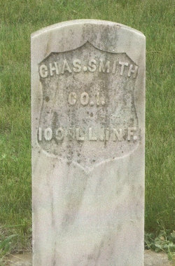
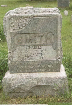
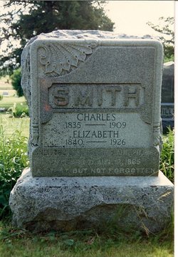
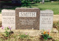
Charles Smith
| Birth | : | 7 Feb 1835 Ohio, USA |
| Death | : | 2 Mar 1909 Oak Hill, Clay County, Kansas, USA |
| Burial | : | Saint Marys Cemetery, Rockville, Sherman County, USA |
| Coordinate | : | 41.1202000, -98.8255000 |
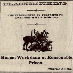
| Description | : | The Times, March 4, 1909, page 5 "Smith:--Chas. Smith departed this life at his home in Oak Hill Monday, March 1st after a long and painful illness with a complication of diseases, aged 74 years and 22 days. The funeral was held at the Presbyterian church Wednesday and was largely attended. Interrment was made in the Rose Meron cemetery south of that place. The deceased was born Feb. 7, 1835 and was married to Miss Elizabeth Dunable at Mt. Vernon, Ohio, Aug 13, 1854. In 1870 he came to Clay county with his family and took a homestead near... Read More |
frequently asked questions (FAQ):
-
Where is Charles Smith's memorial?
Charles Smith's memorial is located at: Saint Marys Cemetery, Rockville, Sherman County, USA.
-
When did Charles Smith death?
Charles Smith death on 2 Mar 1909 in Oak Hill, Clay County, Kansas, USA
-
Where are the coordinates of the Charles Smith's memorial?
Latitude: 41.1202000
Longitude: -98.8255000
Family Members:
Spouse
Children

Flowers:


Nearby Cemetories:
1. Saint Marys Cemetery
Rockville, Sherman County, USA
Coordinate: 41.1202000, -98.8255000
2. Hayestown Cemetery
Rockville, Sherman County, USA
Coordinate: 41.0766983, -98.8043976
3. Zeller Burial Site
Rockville, Sherman County, USA
Coordinate: 41.0725000, -98.8056000
4. Gehrke Cemetery
Rockville, Sherman County, USA
Coordinate: 41.0539800, -98.8299800
5. Souleville Cemetery
Sherman County, USA
Coordinate: 41.0782080, -98.7553360
6. Austin Cemetery
Rockville, Sherman County, USA
Coordinate: 41.1880989, -98.8981018
7. Ebenezer Cemetery
Howard County, USA
Coordinate: 41.1264000, -98.7097015
8. Horak Cemetery
Sherman County, USA
Coordinate: 41.0755900, -98.9305010
9. Immanuel Lutheran Cemetery
Ashton, Sherman County, USA
Coordinate: 41.2140000, -98.8142000
10. Union Cemetery
Ashton, Sherman County, USA
Coordinate: 41.2214012, -98.7855988
11. Our Lady Of Lourdes Cemetery
Ravenna, Buffalo County, USA
Coordinate: 41.0339012, -98.9310989
12. Mount Calvary Cemetery
Ravenna, Buffalo County, USA
Coordinate: 41.0335950, -98.9319980
13. Highland Cemetery
Ravenna, Buffalo County, USA
Coordinate: 41.0331900, -98.9327100
14. Highland Park Cemetery
Ravenna, Buffalo County, USA
Coordinate: 41.0308100, -98.9325900
15. Loup Fork Cemetery
Boelus, Howard County, USA
Coordinate: 41.1052600, -98.6631000
16. Verdurette Cemetery
Sherman County, USA
Coordinate: 41.1697006, -98.9757996
17. Kelso Cemetery
Howard County, USA
Coordinate: 41.1627998, -98.6707993
18. Saint Francis Cemetery
Ashton, Sherman County, USA
Coordinate: 41.2438000, -98.7994000
19. Trinity Lutheran Church Cemetery
Hazard, Sherman County, USA
Coordinate: 41.0913000, -99.0052000
20. Swedish Pioneer Cemetery
Howard County, USA
Coordinate: 41.0910988, -98.6324997
21. Saint Anthony Catholic Cemetery
Farwell, Howard County, USA
Coordinate: 41.1845400, -98.6414700
22. Sodtown Cemetery
Buffalo County, USA
Coordinate: 40.9639015, -98.8155975
23. Nysted Cemetery
Nysted, Howard County, USA
Coordinate: 41.1307983, -98.6136017
24. Danish Lutheran Cemetery
Farwell, Howard County, USA
Coordinate: 41.2134660, -98.6336020