
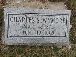
Charles Sumner “Charley” Wymore
| Birth | : | 4 Mar 1875 Oskaloosa, Mahaska County, Iowa, USA |
| Death | : | 19 Jun 1909 Barneston, Gage County, Nebraska, USA |
| Burial | : | Pawnee City Cemetery, Pawnee City, Pawnee County, USA |
| Coordinate | : | 40.1109009, -96.1608810 |
| Plot | : | W 190- 7 |
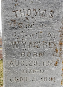
| Description | : | Son of James Thomas "Albie" & Eliza Ann Sarvis Wymore. Married to Lillie Morton Edwards on Oct. 15, 1896 in Pawnee County, Nebraska. (Pawnee Library, book of obits in the Pawnee Republican.) ------------------------------------------------------------- Cause of death, Drowned. (From the Death Records for this cemetery in the Pawnee City Library.) -------------------------------------------------------------- Table Rock Argus, June 24, 1909. (pg5) DROWNED WHILE FISHING- An awful accident, which shocked the community, occurred June 19, when Charley Wymore met his death while fishing in the Blue river near Barneston, Nebraska, and Albert Cox and Ike Knowles nearly lost their lives. The boys were trying to stretch a rope across the river. Albert was... Read More |
frequently asked questions (FAQ):
-
Where is Charles Sumner “Charley” Wymore's memorial?
Charles Sumner “Charley” Wymore's memorial is located at: Pawnee City Cemetery, Pawnee City, Pawnee County, USA.
-
When did Charles Sumner “Charley” Wymore death?
Charles Sumner “Charley” Wymore death on 19 Jun 1909 in Barneston, Gage County, Nebraska, USA
-
Where are the coordinates of the Charles Sumner “Charley” Wymore's memorial?
Latitude: 40.1109009
Longitude: -96.1608810
Family Members:
Parent

Spouse
Siblings
Children
Flowers:


Nearby Cemetories:
1. Pawnee City Cemetery
Pawnee City, Pawnee County, USA
Coordinate: 40.1109009, -96.1608810
2. East Amish Cemetery
Table Rock, Pawnee County, USA
Coordinate: 40.1310000, -96.0854000
3. Evergreen Cemetery
Pawnee County, USA
Coordinate: 40.0485992, -96.1417007
4. Pleasant Valley Cemetery
Pawnee County, USA
Coordinate: 40.0299988, -96.1554794
5. Table Rock Cemetery
Table Rock, Pawnee County, USA
Coordinate: 40.1791400, -96.1037400
6. Prairie Star Pioneer Cemetery
Du Bois, Pawnee County, USA
Coordinate: 40.0293000, -96.1041000
7. Beranek Cemetery
Table Rock, Pawnee County, USA
Coordinate: 40.2042007, -96.1607971
8. Pleasant Ridge Cemetery
Du Bois, Pawnee County, USA
Coordinate: 40.0156000, -96.1494000
9. West Branch Cemetery
Pawnee County, USA
Coordinate: 40.0787940, -96.2797160
10. Saint Anthonys Cemetery
Steinauer, Pawnee County, USA
Coordinate: 40.2075005, -96.2189026
11. Johnson Creek Cemetery
Pawnee City, Pawnee County, USA
Coordinate: 40.0270000, -96.2465000
12. Clear Creek Cemetery
Table Rock, Pawnee County, USA
Coordinate: 40.2193985, -96.1391983
13. Bohemian Cemetery
Table Rock, Pawnee County, USA
Coordinate: 40.1786003, -96.0374985
14. Saint Peters Evangelican Cemetery
Du Bois, Pawnee County, USA
Coordinate: 40.0010000, -96.1095000
15. Dry Branch Pioneer Cemetery
Richardson County, USA
Coordinate: 40.1292000, -96.0100021
16. DuBois Cemetery
Du Bois, Pawnee County, USA
Coordinate: 40.0231018, -96.0488968
17. Bohemian Cemetery
Richardson County, USA
Coordinate: 40.1175003, -95.9955978
18. Saint Johns Cemetery
Table Rock, Pawnee County, USA
Coordinate: 40.2148000, -96.0657000
19. Salems Cemetery
Steinauer, Pawnee County, USA
Coordinate: 40.2166000, -96.2555000
20. McCaffrey Cemetery
Nemaha County, USA
Coordinate: 39.9827100, -96.1474500
21. Madden Cemetery
Axtell, Marshall County, USA
Coordinate: 39.9866800, -96.2490300
22. Friedens United Church of Christ Cemetery
Bern, Nemaha County, USA
Coordinate: 39.9929008, -96.0529480
23. Saint Peters Lutheran Church Cemetery
Steinauer, Pawnee County, USA
Coordinate: 40.2555000, -96.1801000
24. Cincinnati Cemetery
Du Bois, Pawnee County, USA
Coordinate: 40.0042000, -96.0274963