
| Birth | : | 27 Jan 1891 Davis County, Iowa, USA |
| Death | : | 17 Mar 1972 Bloomfield, Davis County, Iowa, USA |
| Burial | : | Greenacres Cemetery, Oldham, Metropolitan Borough of Oldham, England |
| Coordinate | : | 53.5455490, -2.0820510 |
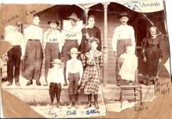
| Description | : | Age 81; Farmer; Son of William and Amanda Downing Birchmier; On August 11, 1915 he married Grace McDowell. Father of Beulah (Cremer) and two sons, Larval and LaVerne; Brother of Ollie (Head), Eva (Barker) and Reva (Greene); Five brothers preceded him in death; |
frequently asked questions (FAQ):
-
Where is Charles X Birchmier's memorial?
Charles X Birchmier's memorial is located at: Greenacres Cemetery, Oldham, Metropolitan Borough of Oldham, England.
-
When did Charles X Birchmier death?
Charles X Birchmier death on 17 Mar 1972 in Bloomfield, Davis County, Iowa, USA
-
Where are the coordinates of the Charles X Birchmier's memorial?
Latitude: 53.5455490
Longitude: -2.0820510
Family Members:
Parent

Spouse

Siblings

Children
Flowers:


Nearby Cemetories:
1. Greenacres Cemetery
Oldham, Metropolitan Borough of Oldham, England
Coordinate: 53.5455490, -2.0820510
2. Greenacres Congregational Church
Oldham, Metropolitan Borough of Oldham, England
Coordinate: 53.5455200, -2.0788100
3. Holy Trinity Churchyard
Waterhead, Metropolitan Borough of Oldham, England
Coordinate: 53.5507100, -2.0738400
4. St. John the Baptist Churchyard
Heybridge, Central Coast Council, Australia
Coordinate: 53.5415973, -2.0699727
5. St. John The Baptist Churchyard
Oldham, Metropolitan Borough of Oldham, England
Coordinate: 53.5424690, -2.0680150
6. St Thomas'
Oldham, Metropolitan Borough of Oldham, England
Coordinate: 53.5366318, -2.0724053
7. Lees Cemetery
Oldham, Metropolitan Borough of Oldham, England
Coordinate: 53.5347540, -2.0739260
8. St. Mary Church of England Churchyard
Oldham, Metropolitan Borough of Oldham, England
Coordinate: 53.5428030, -2.1104030
9. Friends Burial Ground at Turf Lane
Royton, Metropolitan Borough of Oldham, England
Coordinate: 53.5620200, -2.1039660
10. Holy Trinity Churchyard
Shaw, Metropolitan Borough of Oldham, England
Coordinate: 53.5749940, -2.0991780
11. Saint Paul Churchyard
Royton, Metropolitan Borough of Oldham, England
Coordinate: 53.5653330, -2.1261450
12. St. George Parish Churchyard
Mossley, Metropolitan Borough of Tameside, England
Coordinate: 53.5164000, -2.0486200
13. Crompton Cemetery
Shaw, Metropolitan Borough of Oldham, England
Coordinate: 53.5799840, -2.1003410
14. Chadderton Cemetery
Chadderton, Metropolitan Borough of Oldham, England
Coordinate: 53.5464860, -2.1468960
15. Royton Cemetery
Royton, Metropolitan Borough of Oldham, England
Coordinate: 53.5727450, -2.1302850
16. Hollinwood Cemetery
Oldham, Metropolitan Borough of Oldham, England
Coordinate: 53.5178170, -2.1329170
17. Delph Independent Chapelyard
Delph, Metropolitan Borough of Oldham, England
Coordinate: 53.5690839, -2.0225845
18. Oldham Crematorium
Oldham, Metropolitan Borough of Oldham, England
Coordinate: 53.5156810, -2.1332800
19. St Matthew Churchyard
Chadderton, Metropolitan Borough of Oldham, England
Coordinate: 53.5565975, -2.1528452
20. Hurst Cemetery
Ashton-Under-Lyne, Metropolitan Borough of Tameside, England
Coordinate: 53.5011590, -2.0727370
21. St Thomas Churchyard Friarmere
Delph, Metropolitan Borough of Oldham, England
Coordinate: 53.5778800, -2.0285500
22. St. John the Evangelist Churchyard
Hurst, Metropolitan Borough of Tameside, England
Coordinate: 53.5001310, -2.0812490
23. Mossley Cemetery
Mossley, Metropolitan Borough of Tameside, England
Coordinate: 53.5092100, -2.0332700
24. Christ Church Churchyard
Denshaw, Metropolitan Borough of Oldham, England
Coordinate: 53.5918070, -2.0385720