
| Birth | : | 25 Dec 1855 Decorah, Winneshiek County, Iowa, USA |
| Death | : | 15 Jul 1925 Council Bluffs, Pottawattamie County, Iowa, USA |
| Burial | : | Greenwood Cemetery, Clay Center, Clay County, USA |
| Coordinate | : | 39.4011002, -97.1275024 |
| Plot | : | Sec 3 |
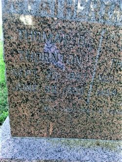
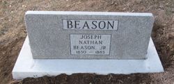
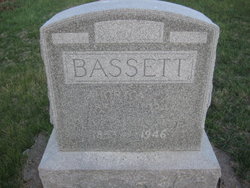
| Description | : | Charlotte E.(Bassett) Ward Beason Thorton was the daughter of Elias and Jane Lillie (Henry) Bassett. She married Henry Ward on November 27, 1874 in Decatur County, Iowa. After his death she married Joseph Beason on September 3, 1879 in Hamburg, Fremont County, Iowa. Son of Joseph and Samantha (Morris) Beason. To this union two children were born Silas and Roy. After Josephs death in 1885. She married Thomas Thornton on September 13, 1888 in Otto County, Nebraska. To this union 5 children were born Oris, Floyd, Mabel, Zora and Clyde. Zora died in 1900 and Clyde died in 1902 Charlotte... Read More |
frequently asked questions (FAQ):
-
Where is Charlotte Bassett Beason Thornton's memorial?
Charlotte Bassett Beason Thornton's memorial is located at: Greenwood Cemetery, Clay Center, Clay County, USA.
-
When did Charlotte Bassett Beason Thornton death?
Charlotte Bassett Beason Thornton death on 15 Jul 1925 in Council Bluffs, Pottawattamie County, Iowa, USA
-
Where are the coordinates of the Charlotte Bassett Beason Thornton's memorial?
Latitude: 39.4011002
Longitude: -97.1275024
Family Members:
Parent
Spouse
Siblings
Children

Flowers:


Nearby Cemetories:
1. Greenwood Cemetery
Clay Center, Clay County, USA
Coordinate: 39.4011002, -97.1275024
2. Saint Peter and Saint Pauls Catholic Cemetery
Clay Center, Clay County, USA
Coordinate: 39.4005450, -97.1236680
3. Clay County Poor Farm Cemetery
Clay Center, Clay County, USA
Coordinate: 39.3772700, -97.0727000
4. Wilson Cemetery
Clay County, USA
Coordinate: 39.3800011, -97.1896973
5. Hayes Cemetery
Clay County, USA
Coordinate: 39.4516983, -97.0811005
6. Republican City Cemetery
Clay Center, Clay County, USA
Coordinate: 39.3431015, -97.1628036
7. Swedish Pleasant Hill Cemetery
Clay Center, Clay County, USA
Coordinate: 39.4735985, -97.1268997
8. Morganville City Cemetery
Morganville, Clay County, USA
Coordinate: 39.4733009, -97.1819000
9. Broughton Cemetery
Clay Center, Clay County, USA
Coordinate: 39.3306007, -97.0535965
10. Swedish Evangelical Lutheran Cemetery
Clay County, USA
Coordinate: 39.4911700, -97.1455100
11. Ebenezer Cemetery
Green, Clay County, USA
Coordinate: 39.3866997, -96.9974976
12. Brethren in Christ Cemetery
Clay County, USA
Coordinate: 39.4810982, -97.0344009
13. Green Cemetery
Green, Clay County, USA
Coordinate: 39.4235992, -96.9882965
14. Norwegian Lutheran Cemetery
Clay Center, Clay County, USA
Coordinate: 39.5027900, -97.1828200
15. Zion Lutheran Cemetery
Clay County, USA
Coordinate: 39.2928009, -97.1557999
16. Idylwilde Cemetery
Clay Center, Clay County, USA
Coordinate: 39.5097900, -97.0713000
17. Idana Cemetery
Idana, Clay County, USA
Coordinate: 39.3574500, -97.2693300
18. Milo Chapman Gravesite
Broughton, Clay County, USA
Coordinate: 39.2888500, -97.0724400
19. Fancy Creek Cemetery
Green, Clay County, USA
Coordinate: 39.4668999, -96.9969025
20. Garfield Center Mission Cemetery
Clay Center, Clay County, USA
Coordinate: 39.5243100, -97.1277500
21. Gilbert Cemetery
Clay County, USA
Coordinate: 39.2853012, -97.0625000
22. Bloom Cemetery
Morganville, Clay County, USA
Coordinate: 39.4519005, -97.2778015
23. Joseph Sender Family Cemetery
Clay County, USA
Coordinate: 39.5090600, -97.0348800
24. Lincoln Cemetery
Clay Center, Clay County, USA
Coordinate: 39.4230995, -97.2930984