
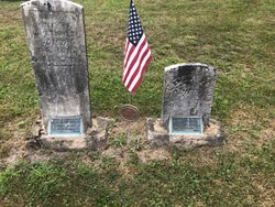
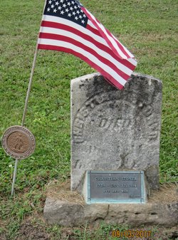
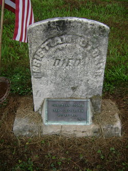
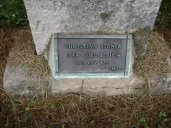
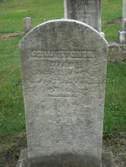
Christian Herr Stoner
| Birth | : | 1758 Chester County, Pennsylvania, USA |
| Death | : | 12 Dec 1814 Westmoreland County, Pennsylvania, USA |
| Burial | : | Alverton Cemetery, Alverton, Westmoreland County, USA |
| Coordinate | : | 40.1410000, -79.5890000 |
| Inscription | : | PVT. REV. WAR JHS 1979 |
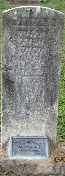
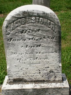
| Description | : | Served as a Pvt in the Revolutionary War. Married Barbara Shank 30 Dec 1783 in Bedford, Pennsylvania. Excerpts from Genealogical and personal history of Fayette County, Pennsylvania: Son of an emigrant from Switzerland, was a farmer in Bedford county until 1799, when he moved to Westmoreland county, settling in East Huntingdon township, where he secured title to three hundred acres of good land, and followed farming until his death in 1814. Prior to his demise he divided his farm among four of his sons, John, Abraham, Jacob and Daniel. His wife, Barbara Shank, came from Bedford county with him and died... Read More |
frequently asked questions (FAQ):
-
Where is Christian Herr Stoner's memorial?
Christian Herr Stoner's memorial is located at: Alverton Cemetery, Alverton, Westmoreland County, USA.
-
When did Christian Herr Stoner death?
Christian Herr Stoner death on 12 Dec 1814 in Westmoreland County, Pennsylvania, USA
-
Where are the coordinates of the Christian Herr Stoner's memorial?
Latitude: 40.1410000
Longitude: -79.5890000
Family Members:
Spouse
Children

Flowers:


Nearby Cemetories:
1. Alverton Cemetery
Alverton, Westmoreland County, USA
Coordinate: 40.1410000, -79.5890000
2. Mount Zion Lutheran and Reformed Cemetery
Mayfield, Westmoreland County, USA
Coordinate: 40.1423035, -79.6093979
3. Zion Cemetery
Alverton, Westmoreland County, USA
Coordinate: 40.1423650, -79.6094020
4. Roman Catholic Polish Cemetery of the Transfigurat
Mount Pleasant, Westmoreland County, USA
Coordinate: 40.1558800, -79.5631700
5. Saint Pius X Cemetery
Mount Pleasant, Westmoreland County, USA
Coordinate: 40.1438200, -79.5461200
6. Visitation Parish Cemetery
Mount Pleasant, Westmoreland County, USA
Coordinate: 40.1439600, -79.5447200
7. Old United Presbyterian Graveyard
Mount Pleasant, Westmoreland County, USA
Coordinate: 40.1500824, -79.5452369
8. Mount Pleasant Cemetery
Mount Pleasant, Westmoreland County, USA
Coordinate: 40.1571999, -79.5475006
9. Fairview Church Cemetery
Hammondville, Fayette County, USA
Coordinate: 40.1169014, -79.5333023
10. Middle Presbyterian Cemetery
Mount Pleasant, Westmoreland County, USA
Coordinate: 40.1777000, -79.5309000
11. Saint Josef's Polish Catholic Cemetery
Everson, Fayette County, USA
Coordinate: 40.0830000, -79.5752000
12. Saint John's Union Cemetery
Mount Pleasant, Westmoreland County, USA
Coordinate: 40.1814000, -79.5316000
13. Greenlick Cemetery
Fayette County, USA
Coordinate: 40.1105995, -79.5194016
14. Pennsville Independent Cemetery
Connellsville, Fayette County, USA
Coordinate: 40.0844002, -79.5566711
15. Mount Joy Church Of The Brethren Cemetery
Mount Pleasant, Westmoreland County, USA
Coordinate: 40.1439000, -79.5054000
16. King Cemetery
Fayette County, USA
Coordinate: 40.0764300, -79.6005800
17. Brothers Cemetery
Fayette County, USA
Coordinate: 40.1360700, -79.5004300
18. Tyrone United Presbyterian Church Cemetery
Dawson, Fayette County, USA
Coordinate: 40.0740000, -79.6306000
19. Green Ridge Memorial Park
Connellsville, Fayette County, USA
Coordinate: 40.0682983, -79.5622025
20. Lobingier Cemetery
Mount Pleasant Township, Westmoreland County, USA
Coordinate: 40.1439030, -79.4887870
21. Stone Hill Cemetery
Hempfield Township, Westmoreland County, USA
Coordinate: 40.2220000, -79.5776000
22. Boyd Cemetery
Connellsville, Fayette County, USA
Coordinate: 40.0595000, -79.5776400
23. Mount Olive Cemetery
Connellsville, Fayette County, USA
Coordinate: 40.0645000, -79.5445000
24. Mellinger Cemetery
Mellingertown, Westmoreland County, USA
Coordinate: 40.1432050, -79.4784730