
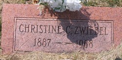
Christine Catherine Zwiebel
| Birth | : | 10 Jan 1887 Omaha, Douglas County, Nebraska, USA |
| Death | : | 27 Dec 1968 Omaha, Douglas County, Nebraska, USA |
| Burial | : | Grove Hill Cemetery, Lisbon, Grafton County, USA |
| Coordinate | : | 44.2108002, -71.9094009 |
frequently asked questions (FAQ):
-
Where is Christine Catherine Zwiebel's memorial?
Christine Catherine Zwiebel's memorial is located at: Grove Hill Cemetery, Lisbon, Grafton County, USA.
-
When did Christine Catherine Zwiebel death?
Christine Catherine Zwiebel death on 27 Dec 1968 in Omaha, Douglas County, Nebraska, USA
-
Where are the coordinates of the Christine Catherine Zwiebel's memorial?
Latitude: 44.2108002
Longitude: -71.9094009
Family Members:
Parent
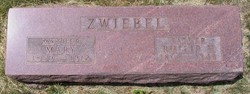

Siblings
Flowers:


Nearby Cemetories:
1. Grove Hill Cemetery
Lisbon, Grafton County, USA
Coordinate: 44.2108002, -71.9094009
2. Salmon Hole Cemetery
Lisbon, Grafton County, USA
Coordinate: 44.2359600, -71.8848200
3. Pettyboro District Cemetery
Pettyboro, Grafton County, USA
Coordinate: 44.2038310, -71.9620880
4. Landaff Center Cemetery
Landaff, Grafton County, USA
Coordinate: 44.1739860, -71.8847040
5. Parker Hill Cemetery
Lyman, Grafton County, USA
Coordinate: 44.2582400, -71.9458800
6. Bath Village Cemetery
Bath, Grafton County, USA
Coordinate: 44.1693500, -71.9617800
7. Pond Cemetery
Lyman, Grafton County, USA
Coordinate: 44.2671800, -71.9093700
8. Center Cemetery
Lyman, Grafton County, USA
Coordinate: 44.2672200, -71.9381400
9. Noyes Cemetery
Landaff, Grafton County, USA
Coordinate: 44.1830560, -71.8286110
10. Moulton Hill Cemetery
Lyman, Grafton County, USA
Coordinate: 44.2457400, -71.9862900
11. West Bath Cemetery
Bath, Grafton County, USA
Coordinate: 44.1750930, -71.9865080
12. Upper Smith Road Cemetery
Bath, Grafton County, USA
Coordinate: 44.2202780, -72.0075000
13. Sunnyside Cemetery
Sugar Hill, Grafton County, USA
Coordinate: 44.2130300, -71.8061600
14. Swiftwater Cemetery
Bath, Grafton County, USA
Coordinate: 44.1303400, -71.9574300
15. Bedel Cemetery
Bath, Grafton County, USA
Coordinate: 44.2075000, -72.0455560
16. Carbee District Cemetery
Bath, Grafton County, USA
Coordinate: 44.1881040, -72.0521310
17. Carbee Cemetery
Bath, Grafton County, USA
Coordinate: 44.1724640, -72.0466980
18. Monroe Village Cemetery
Monroe, Grafton County, USA
Coordinate: 44.2558400, -72.0427900
19. Pine Grove Cemetery
Woodsville, Grafton County, USA
Coordinate: 44.1380997, -72.0188980
20. Saint Joseph Cemetery
Bath, Grafton County, USA
Coordinate: 44.1803017, -72.0524979
21. West Cemetery
Benton, Grafton County, USA
Coordinate: 44.1033700, -71.9014000
22. Willow Cemetery
Franconia, Grafton County, USA
Coordinate: 44.1968994, -71.7530975
23. East Cemetery
Benton, Grafton County, USA
Coordinate: 44.0985985, -71.8846970
24. North Monroe Cemetery
Monroe, Grafton County, USA
Coordinate: 44.3067680, -71.9998780