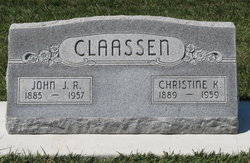
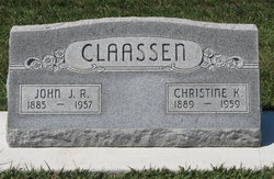
Christine Katharine “Tina” Penner Claassen
| Birth | : | 12 Sep 1889 Marion County, Kansas, USA |
| Death | : | 10 Mar 1959 Beatrice, Gage County, Nebraska, USA |
| Burial | : | Mebane Cemetery, Carroll County, USA |
| Coordinate | : | 36.0689011, -88.3311005 |
| Plot | : | L 92 |
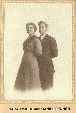
| Description | : | Christina Claassen was born Sept. 12, 1889 to Heinrich Daniel (H.D.) and Katharina (Dalke) Penner in Marion County, Kansas. Her parents were Russian-German Mennonites, but Tina and all her siblings were born in Kansas. In 1910, Tina K Penner was 20, and attending Bethel College, in North Newton, Kansas. She was living at home, and there were 12 living children (her mother, told the census takers that 2 had passed away). That year her father, H.D. Penner was teaching in a preparatory school. The children living at home were: Rachel R (24) teaching... Read More |
frequently asked questions (FAQ):
-
Where is Christine Katharine “Tina” Penner Claassen's memorial?
Christine Katharine “Tina” Penner Claassen's memorial is located at: Mebane Cemetery, Carroll County, USA.
-
When did Christine Katharine “Tina” Penner Claassen death?
Christine Katharine “Tina” Penner Claassen death on 10 Mar 1959 in Beatrice, Gage County, Nebraska, USA
-
Where are the coordinates of the Christine Katharine “Tina” Penner Claassen's memorial?
Latitude: 36.0689011
Longitude: -88.3311005
Family Members:
Parent
Spouse
Siblings
Children
Flowers:
Nearby Cemetories:
1. Mebane Cemetery
Carroll County, USA
Coordinate: 36.0689011, -88.3311005
2. Nesbitt Cemetery
Hollow Rock, Carroll County, USA
Coordinate: 36.0633011, -88.3218994
3. Bethlehem Cemetery
Huntingdon, Carroll County, USA
Coordinate: 36.0603386, -88.3503248
4. Old Union Cemetery
Carroll County, USA
Coordinate: 36.0891991, -88.3319016
5. Barren Springs Church Cemetery
Hollow Rock, Carroll County, USA
Coordinate: 36.0890140, -88.3152590
6. Hebron Cemetery
Carroll County, USA
Coordinate: 36.0410995, -88.3199997
7. Mount Pleasant Baptist Church Cemetery
Huntingdon, Carroll County, USA
Coordinate: 36.0388090, -88.3440580
8. Thompson Cemetery
Bruceton, Carroll County, USA
Coordinate: 36.0321880, -88.3202350
9. Mann Cemetery
Huntingdon, Carroll County, USA
Coordinate: 36.1023220, -88.3591000
10. Massey Family Cemetery
Bruceton, Carroll County, USA
Coordinate: 36.1033600, -88.2947270
11. New Cross Roads Church Cemetery
Huntingdon, Carroll County, USA
Coordinate: 36.0425090, -88.3770950
12. New Prospect Cemetery
Hollow Rock, Carroll County, USA
Coordinate: 36.0579930, -88.2734330
13. Harder Cemetery
Carroll County, USA
Coordinate: 36.1094017, -88.3711014
14. Abernathy Cemetery
Carroll County, USA
Coordinate: 36.1180992, -88.3533020
15. Chapel Hill Cemetery
Huntingdon, Carroll County, USA
Coordinate: 36.1088982, -88.3735962
16. Massey-Liles Cemetery
Carroll County, USA
Coordinate: 36.1133003, -88.2947006
17. McMillan Cemetery
Huntingdon, Carroll County, USA
Coordinate: 36.0200680, -88.3600460
18. Marlboro Church of Christ Cemetery
Bruceton, Carroll County, USA
Coordinate: 36.0919200, -88.2693600
19. Pisgah Cemetery
Hollow Rock, Carroll County, USA
Coordinate: 36.0788570, -88.2638470
20. Marlsboro Missionary Baptist Church Cemetery
Carroll County, USA
Coordinate: 36.0928001, -88.2694016
21. Twin Oaks Community Cemetery
Huntingdon, Carroll County, USA
Coordinate: 36.0207420, -88.3707170
22. Prospect Cemetery
Hollow Rock, Carroll County, USA
Coordinate: 36.0346985, -88.2703018
23. Long Rock Church Cemetery
Huntingdon, Carroll County, USA
Coordinate: 36.0479480, -88.4014670
24. Old Pisgah Church Cemetery
Bruceton, Carroll County, USA
Coordinate: 36.0602989, -88.2553024

