
| Birth | : | 8 Oct 1866 Cuba, Fulton County, Illinois, USA |
| Death | : | 6 Jul 1889 Rooks County, Kansas, USA |
| Burial | : | Ash Rock Cemetery, Woodston, Rooks County, USA |
| Coordinate | : | 39.5248909, -99.0817719 |
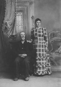
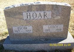
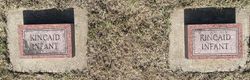
| Description | : | Clara married William Kincaid on 25 Dec 1884. She had two babies buried in Ash Rock and later when she was pregnant, she went blind and died of kidney poisoning on 6 July 1889. Mary Helen (Churchill) Hoar could not attend her daughter's funeral as she was ready to have her baby Mary. |
frequently asked questions (FAQ):
-
Where is Clara Hoar Kincaid's memorial?
Clara Hoar Kincaid's memorial is located at: Ash Rock Cemetery, Woodston, Rooks County, USA.
-
When did Clara Hoar Kincaid death?
Clara Hoar Kincaid death on 6 Jul 1889 in Rooks County, Kansas, USA
-
Where are the coordinates of the Clara Hoar Kincaid's memorial?
Latitude: 39.5248909
Longitude: -99.0817719
Family Members:
Parent

Spouse
Siblings

Children
Flowers:


Nearby Cemetories:
1. Ash Rock Cemetery
Woodston, Rooks County, USA
Coordinate: 39.5248909, -99.0817719
2. Spring Branch Cemetery
Woodston, Rooks County, USA
Coordinate: 39.5099983, -99.0580978
3. Pleasant Ridge Cemetery
Kirwin, Phillips County, USA
Coordinate: 39.5963000, -99.1234000
4. Grant Center Cemetery
Alton, Osborne County, USA
Coordinate: 39.5242004, -98.9708023
5. Pleasant Valley Cemetery
Osborne County, USA
Coordinate: 39.4583015, -99.0077972
6. Woodston Cemetery
Woodston, Rooks County, USA
Coordinate: 39.4375000, -99.1268997
7. Pioneer Cemetery
Alton, Osborne County, USA
Coordinate: 39.4742012, -98.9749985
8. Bohemian Cemetery
Claudell, Smith County, USA
Coordinate: 39.6187800, -99.0428200
9. Leasburg Cemetery
Cedar, Smith County, USA
Coordinate: 39.5819016, -98.9728012
10. West Hope Cemetery
Rooks County, USA
Coordinate: 39.5024986, -99.2110977
11. Greenwood Cemetery
Kirwin, Phillips County, USA
Coordinate: 39.5931900, -99.2064600
12. Sumner Cemetery
Alton, Osborne County, USA
Coordinate: 39.4799995, -98.9338913
13. Saint Francis Catholic Cemetery
Cedar, Smith County, USA
Coordinate: 39.6328011, -98.9816971
14. Bow Creek Cemetery
Glade, Phillips County, USA
Coordinate: 39.5681000, -99.2696991
15. Survey Cemetery
Woodston, Rooks County, USA
Coordinate: 39.3722000, -99.1333008
16. Kirwin Cemetery
Kirwin, Phillips County, USA
Coordinate: 39.6781006, -99.1421967
17. Stockton Cemetery
Stockton, Rooks County, USA
Coordinate: 39.4406700, -99.2647400
18. Saint Thomas Cemetery
Stockton, Rooks County, USA
Coordinate: 39.4449997, -99.2771988
19. Mount Ayr Cemetery
Alton, Osborne County, USA
Coordinate: 39.3764000, -98.9717026
20. Butler Cemetery
Osborne County, USA
Coordinate: 39.5400009, -98.8494034
21. Old Stockton Cemetery
Stockton, Rooks County, USA
Coordinate: 39.4597015, -99.3050003
22. Cedar Cemetery
Cedar, Smith County, USA
Coordinate: 39.6685982, -98.9310989
23. Bigge Family Cemetery
Stockton, Rooks County, USA
Coordinate: 39.4584700, -99.3053200
24. Pleasant Plain Cemetery
Osborne County, USA
Coordinate: 39.3367004, -99.0372009